Southern Hemisphere Parallels: From 26 to 30 Degrees South
Circles of latitude, also known as parallels, are imaginary lines that run east-west around the Earth, parallel to the equator. These lines are essential for navigation, defining political borders, and understanding the astronomical patterns of our planet. The region between the 26th and 30th parallels south spans several continents and oceans, playing a critical role in the geography of Africa, South America, and particularly Australia.
Key Facts
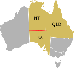
- The 26th parallel south defines the northern border of South Australia and the southern border of the Northern Territory.
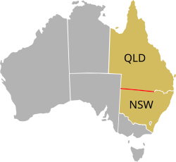
- The 29th parallel south marks a significant portion of the border between Queensland and New South Wales.
- The 30th parallel south is located exactly one-third of the way from the equator to the South Pole.
- Due to Earth's oblateness (the flattening of the poles), the 30th parallel does not perfectly divide the Southern Hemisphere's area in half.
- Daylight hours vary significantly across these latitudes, ranging from approximately 10 to 14 hours depending on the solstice.
The 26th Parallel South
The 26th parallel south is a circle of latitude located 26 degrees south of Earth's equatorial plane. This line traverses the Atlantic Ocean, Africa, the Indian Ocean, Australia, the Pacific Ocean, and South America.
In Australia, this parallel is fundamental to state boundaries. It defines the northernmost border of South Australia and the southernmost border of the Northern Territory. It also marks the border between Queensland and South Australia between the 138th and 141st meridians east.
Interestingly, a small section of the Western Australia/Northern Territory border at Surveyor Generals Corner is defined by this parallel for approximately 127 metres. This anomaly exists because of inaccuracies in fixing positions during the 1920s, caused by the technological constraints of that era.
The 27th and 28th Parallels South
Both the 27th and 28th parallels south cross the Atlantic Ocean, Africa, the Indian Ocean, Australasia, the Pacific Ocean, and South America. These latitudes experience distinct seasonal shifts in daylight.
27th Parallel South
At 27° south, the sun is visible for 13 hours and 52 minutes during the December solstice and 10 hours and 24 minutes during the June solstice.
28th Parallel South
At 28° south, the daylight duration increases slightly during the summer, with 13 hours and 57 minutes of sun during the December solstice and 10 hours and 19 minutes during the June solstice.
The 29th Parallel South
The 29th parallel south continues the path through the Atlantic, Africa, the Indian Ocean, Australasia, the Pacific, and South America. In the context of Australian geography, this parallel is most notable for defining much of the border between the states of Queensland and New South Wales.
The 30th Parallel South
The 30th parallel south is situated 30 degrees south of the equator, placing it exactly one-third of the distance toward the South Pole. It crosses Africa, the Indian Ocean, Australia, the Pacific Ocean, South America, and the Atlantic Ocean.
From a geometric perspective, if Earth were a perfect sphere, the 30th parallel would divide the area of the Southern Hemisphere exactly in half. However, because Earth is an oblate spheroid, the actual dividing line lies slightly to the north.
Solar patterns at this latitude are pronounced. During the summer solstice, the sun is visible for 14 hours and 5 minutes, reaching a height of 83.83 degrees at solar noon on 21 December. Conversely, during the winter solstice, the sun is visible for 10 hours and 13 minutes, reaching only 36.17 degrees on 21 June.
Summary of Latitude Characteristics
| Parallel | Key Geographic/Political Feature | Dec Solstice Daylight | Jun Solstice Daylight |
|---|---|---|---|
| 26° S | SA/NT and QLD/SA Borders (Australia) | N/A | N/A |
| 27° S | Crosses 5 major regions | 13h 52m | 10h 24m |
| 28° S | Crosses 5 major regions | 13h 57m | 10h 19m |
| 29° S | QLD/NSW Border (Australia) | N/A | N/A |
| 30° S | 1/3 distance to South Pole | 14h 05m | 10h 13m |
Frequently Asked Questions
Which Australian borders are defined by the 26th parallel south?
The 26th parallel south defines the northern border of South Australia, the southern border of the Northern Territory, and part of the border between Queensland and South Australia.
Why is there a 127-metre discrepancy at Surveyor Generals Corner?
This discrepancy occurred due to inaccuracies in fixing positions during the 1920s, as the technology available at the time was limited.
Does the 30th parallel south divide the Southern Hemisphere in half?
Not exactly. While it would do so if Earth were a perfect sphere, Earth's oblateness means the true dividing line is located slightly to the north.
How does daylight vary at the 30th parallel south?
Daylight ranges from 14 hours and 5 minutes during the summer solstice (December) to 10 hours and 13 minutes during the winter solstice (June).
Which parallel defines the border between Queensland and New South Wales?
Much of the border between Queensland and New South Wales is defined by the 29th parallel south.