Circles of Latitude: The Science of Earth's Parallels
When we look at a world map, we see a grid of intersecting lines that allow us to pinpoint any location on the planet. Among these, the circles of latitude—often called parallels—serve as the primary markers for north-south positioning. Unlike the lines of longitude that meet at the poles, these circles run east-to-west and never intersect, creating a series of concentric rings around the Earth.
These abstract circles connect all locations at a specific latitude coordinate, ignoring elevation. While they appear as straight lines on many maps, they are actually circles that vary in size; the Equator is the largest, and the circles become progressively smaller as they approach the North and South Poles.
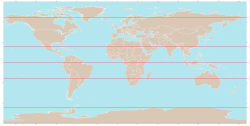
Key Facts
- The Equator is the only circle of latitude that is also a great circle (a circle centered on the Earth's center).
- Parallels are called such because the planes containing them never intersect.
- Axial Tilt determines the position of the tropical and polar circles.
- Map Projections like the Mercator or Gall-Peters distort the spacing of these circles to prioritize either shape or area.
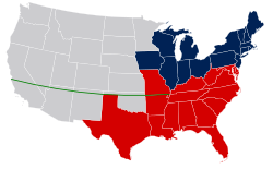
- Political Borders often use parallels as artificial boundaries, such as the 49th parallel between the US and Canada.
How Latitude Works
Latitude is measured as the angle between the Equator and a specific circle, with the vertex of the angle located at the center of the Earth. The Equator is designated as 0°, while the North and South Poles are 90° N and 90° S, respectively.
Between the Equator and each pole, there are 89 whole-degree circles. For higher precision, these are often expressed as decimal degrees (e.g., 34.637° N) or through minutes and seconds (e.g., 22°14′26″ S).
The Role of Map Projections
Because the Earth is a sphere (or more accurately, an ellipsoid) and a map is a flat plane, circles of latitude are represented differently depending on the projection used:
- Equirectangular Projection: Circles are horizontal, parallel, and equally spaced.
- Mercator Projection: Circles are spaced more widely near the poles to preserve local shapes and scales.
- Gall-Peters Projection: Circles are spaced more closely near the poles to ensure area comparisons are accurate.
Elevation and Geometry
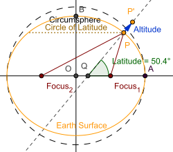
In a geodetic system, latitude is typically defined at zero elevation. However, because altitude and depth are measured along a normal (a line perpendicular to the surface), points at the same latitude but different elevations do not lie on a flat plane. Instead, they form the surface of a truncated cone created by the rotation of that normal around the Earth's axis.
The Five Major Circles of Latitude
While there are many parallels, five are of primary geographical importance. Except for the Equator, the positions of these circles depend on the Earth's axial tilt relative to its orbital plane.
| Circle Name | Latitude | Significance |
|---|---|---|
| Arctic Circle | 66°33′51.0″ N | Southernmost point in North where 24-hour day/night occurs. |
| Tropic of Cancer | 23°26′09.0″ N | Northernmost point where the Sun can be directly overhead. |
| Equator | 0° | Divides Northern and Southern Hemispheres. |
| Tropic of Capricorn | 23°26′09.0″ S | Southernmost point where the Sun can be directly overhead. |
| Antarctic Circle | 66°33′51.0″ S | Northernmost point in South where 24-hour day/night occurs. |
The Dynamics of Axial Tilt
The positions of the tropical and polar circles are not static. They are governed by the obliquity of the ecliptic (the tilt of Earth's axis). If the Earth were perfectly upright, these circles would not exist.
This tilt fluctuates over a 41,000-year cycle between approximately 22.1° and 24.5°. Currently, the tilt is decreasing by about 0.468″ per year, causing the Tropical Circles to drift toward the equator and the Polar Circles toward the poles by roughly 15 meters annually. Shorter-term variations also occur due to nutation (a periodic oscillation with a main 18.6-year cycle) and polar motion (small fluctuations of the rotational axis within the Earth).
Parallels as Political Boundaries
Because latitude can be measured astronomically (by sighting the North Star in the Northern Hemisphere), parallels are often used to draw artificial borders in regions lacking natural landmarks, such as deserts.
- 49° N: Defines a significant portion of the border between the United States and Canada.
- 38° N: Historically served as the boundary between Soviet and American occupation zones in Korea.
- 17° N: The division between North and South Vietnam during the Vietnam War.
- 60° N: Used in Canada to separate the provinces from the territories (the "north of sixty" region).
Frequently Asked Questions
Why are circles of latitude called parallels?
They are called parallels because the planes that contain these circles never intersect one another, meaning they remain equidistant from each other across the surface of the Earth.
Is the Equator a great circle?
Yes, the Equator is the only circle of latitude that is also a great circle, meaning its center is the same as the center of the Earth.
How does the axial tilt affect the Tropics?
The latitude of the tropical circles is equal to the Earth's axial tilt. As the tilt changes over thousands of years, the Tropics shift toward or away from the Equator.
Do other planets have circles of latitude?
Yes, any planet with an axial inclination relative to its orbital plane can have these circles. For example, Pluto's extreme tilt would place its tropic circles closer to the poles and its polar circles closer to the equator.
Why are latitude lines spaced differently on a Mercator map?
On a Mercator projection, the spacing increases near the poles to preserve local shapes and angles, which is highly useful for marine navigation but distorts the size of landmasses.