Northern Hemisphere: Geography, Climate, and Science
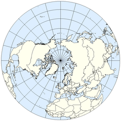
The Northern Hemisphere is the half of planet Earth that lies north of the equator. While it shares the globe with the Southern Hemisphere, it possesses distinct geographical, climatic, and astronomical characteristics that shape the lives of the vast majority of the human population.
Key Facts
- Population: Home to approximately 6.4 billion people (about 87% of the global population as of 2015).
- Land Mass: Contains 67.3% of Earth's total land.
- Water Coverage: 60.7% of its surface is covered by water.
- Axial Tilt: Earth's tilt of 23.439281° creates seasonal variations in temperature and daylight.
- Rotation: Large-scale air and water flows generally move in a clockwise direction due to the Coriolis effect.
Geography and Land Distribution
The Northern Hemisphere is characterized by a significantly higher proportion of land compared to the south. It encompasses the entirety of North America and mainland Eurasia, as well as approximately two-thirds of Africa and a small northern portion of South America.
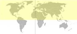
This distribution of land and water creates a unique environmental balance. While the Southern Hemisphere is roughly 80.9% water, the Northern Hemisphere's 60.7% water coverage allows for vast continental interiors and diverse terrestrial ecosystems.
Climate Zones and Geological History
The climate of the Northern Hemisphere is divided into three primary zones based on latitude:
- The Arctic: Centered around the North Pole (90° latitude), this region is known for cold winters and cool summers. Within the Arctic Circle (66°34′ latitude), the region experiences extreme light cycles, including days where the sun never sets in summer and never rises in winter.
- The Northern Temperate Zone: Located between the Arctic Circle and the Tropic of Cancer (23°26′ latitude), this area generally experiences mild seasonal transitions, though weather can be highly unpredictable.
- The Tropical Regions: Situated between the Tropic of Cancer and the equator (0° latitude), these areas remain hot year-round, typically alternating between a rainy summer season and a dry winter season.
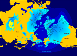
Geologically, the region has been shaped by the Pleistocene epoch (beginning 2.5 million years ago). During this time, the Northern Hemisphere underwent numerous "glacials"—periods where massive continental ice sheets advanced across Europe and North America every 40,000 to 100,000 years. These were separated by shorter, warmer "interglacials" lasting 10,000 to 15,000 years. We are currently living in the Holocene, the most recent interglacial period of the Quaternary.
The Science of Motion: The Coriolis Effect
One of the most defining physical characteristics of the Northern Hemisphere is the Coriolis effect, a phenomenon where objects moving across the Earth's surface are deflected to the right. This has a profound impact on global weather and ocean patterns:
Oceanic Circulation
Trade winds blow east to west near the equator, pushing surface water westward. Due to the Coriolis effect, these currents bend north and right. At roughly 30 degrees north latitude, the westerlies push the water back east, creating a closed, clockwise loop known as a gyre. These are most prominent in the North Atlantic and North Pacific oceans.
Atmospheric Patterns
Air circulation follows similar rules. High-pressure weather cells typically circulate air in a clockwise pattern. Conversely, low-pressure systems—such as hurricanes and tropical storms—draw air inward in a counterclockwise direction.
Astronomy and Observation
The perspective of the sky differs significantly depending on the hemisphere. In the North, the shadow of a sundial moves clockwise, and the midday sun is typically positioned to the south.
Observers in the Northern Hemisphere will notice that the Moon appears inverted compared to how it is seen from the south. Furthermore, because the North Pole faces away from the Galactic Center of the Milky Way, the galaxy appears dimmer and sparser here. This lack of "blinding" light from the Milky Way makes the Northern Hemisphere an ideal location for deep-space observation.

Demographics and Global Distribution
The Northern Hemisphere is the primary center of human population. As of 2015, approximately 6.4 billion of the world's 7.3 billion people reside north of the equator. This concentration is largely due to the greater availability of land mass compared to the Southern Hemisphere.
| Feature | Northern Hemisphere Value | Southern Hemisphere Value |
|---|---|---|
| Land Percentage | 67.3% | 32.7% |
| Water Percentage | 60.7% | 80.9% |
| Human Population (2015) | ~6.4 Billion (87%) | ~0.9 Billion (13%) |
| Primary Rotation | Clockwise (Gyres/High Pressure) | Counter-clockwise (Gyres/High Pressure) |
Frequently Asked Questions
Why do hurricanes spin counterclockwise in the Northern Hemisphere?
Hurricanes are massive low-pressure systems. Because of the Coriolis effect, air rushing toward the center of the low-pressure zone is deflected to the right, resulting in a counterclockwise spiral.
What is the "Midnight Sun"?
The Midnight Sun occurs inside the Arctic Circle (66°34′ latitude) during the summer. Due to the Earth's axial tilt, certain locations remain tilted toward the sun for 24 hours a day, meaning the sun never sets below the horizon.
How do seasons work in the Northern Hemisphere?
Seasons are caused by Earth's axial tilt of 23.439281°. Winter typically spans from the December solstice to the March equinox, while summer lasts from the June solstice to the September equinox.
Why is the Northern Hemisphere better for deep-space observation?
The North Pole faces away from the Galactic Center of the Milky Way. This makes the Milky Way appear dimmer and sparser in the northern sky, reducing the light interference that can hinder the observation of distant deep-space objects.
What is the difference between a glacial and an interglacial period?
A glacial period is a cold phase characterized by the advance of continental ice sheets. An interglacial period is a shorter, more temperate phase between glacials; the Holocene is the current interglacial period.