Saarland: A Unique Blend of German and French Heritage
Located in the southwest of Germany, Saarland is a landlocked state known for its complex history and deep cultural ties to its neighbors. While it is one of the smallest German states by both area and population, its strategic location and industrial legacy have made it a focal point of European geopolitics for centuries.
With its capital in Saarbrücken, the state serves as a bridge between Germany, France, and Luxembourg. Its identity is shaped by a history of shifting borders, a powerful industrial past, and a modern commitment to bilingualism.
Key Facts
- Capital: Saarbrücken
- Population: 1,012,141 (2024)
- Total Area: 2,571.52 km²
- GDP: €43.174 billion (2025)
- HDI: 0.934 (Very High)
- Official Language: German (with a strong push toward French bilingualism)
Geography and Administration
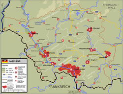
Saarland is roughly the same size as Luxembourg. In the context of Germany, it is the smallest Flächenland (area-state), meaning it is not a city-state like Berlin, Hamburg, or Bremen. The landscape is generally hilly, with the Dollberg reaching a peak of 695.4 meters. Notably, one-third of the state is covered by forest, one of the highest proportions in Germany.
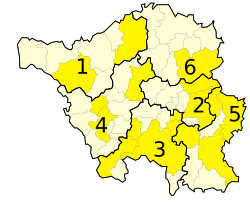
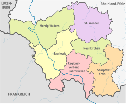
The state is divided into six administrative districts: Merzig-Wadern, Neunkirchen, Saarbrücken, Saarlouis, Saarpfalz-Kreis, and Sankt Wendel.
A Turbulent History of Borders
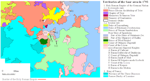
The history of Saarland is defined by its position between the spheres of influence of France and Germany. After Roman rule ended in the 5th century, the region was governed by the Franks and later became part of the Holy Roman Empire. From the 17th century, French kings sought to incorporate the territory, leading to several invasions and the establishment of the stronghold of Saarlouis in 1680.
The Napoleonic Era and the German Empire
The French Revolution terminated the independence of local states in the region, integrating them into the French Republic. However, following Napoleon's defeat in 1815, the territory was partitioned between the Prussian Rhine Province, the Kingdom of Bavaria, and the Duke of Oldenburg. By 1871, the region became part of the newly formed German Empire.
The Interwar Period and the Saar Protectorate
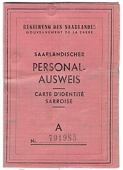
Following World War I, the Treaty of Versailles placed the region under a League of Nations mandate administered by France. A 1935 plebiscite saw 90.8% of voters choose to rejoin Nazi Germany. After World War II, the territory again fell under French control as the Saar Protectorate, using its own currency (the Saar franc) and postage stamps until 1959.
The final transition occurred after the 1955 Saar Statute referendum, where residents rejected independence. On January 1, 1957, Saarland officially joined the Federal Republic of Germany.
Demographics and Society
Saarland is recognized as the most religious state in Germany. A majority of the population (56.8%) identifies as Roman Catholic, while 17.5% are Protestant. The state is also characterized by its international population, with significant communities from Syria, Italy, and Ukraine.
Language and Culture
Due to its proximity to France, the French language holds a special status. It is compulsory in many schools, and the state government has set an ambitious goal to make the region fully bilingual in German and French by 2043.
Major Urban Centers
| Rank | City | Population | Area (km²) | Density (Pop/km²) |
|---|---|---|---|---|
| 1 | Saarbrücken | 180,966 | 168 | 1,080 |
| 2 | Neunkirchen | 46,767 | 75 | 621 |
| 3 | Homburg (Saar) | 41,934 | 83 | 508 |
| 4 | Völklingen | 39,376 | 67 | 587 |
| 5 | Sankt Ingbert | 35,951 | 50 | 720 |
| 6 | Saarlouis | 34,532 | 43 | 798 |
| 7 | Merzig | 29,818 | 109 | 274 |
| 8 | Sankt Wendel | 25,959 | 114 | 229 |
| 9 | Blieskastel | 20,770 | 108 | 192 |
| 10 | Dillingen | 20,143 | 22 | 914 |
Economy and Industry
Historically, Saarland's economy was built on coal mining and steel. However, the region has undergone a significant transition. The last coal mine closed in 2012 due to safety concerns regarding earthquakes, ending 250 years of mining history.
Today, the economy is driven by the automobile industry, steel production, ceramics, and the computer science and information systems sector. As of 2025, the state's GDP stands at €43.174 billion, with a per capita GDP of €42,656.
Tourism and Landmarks
Saarland offers a mix of industrial heritage and natural beauty. The Völklingen Ironworks is a UNESCO World Heritage site and a primary attraction. Other notable sites include the Roman Villa Borg, the Saarlandmuseum, and the scenic Saarschleife (Saar Loop).
Frequently Asked Questions
When did Saarland officially become part of Germany?
Saarland joined the Federal Republic of Germany as a state on January 1, 1957, following a referendum in 1955 that rejected the proposal for the region to become an independent territory.
What is the significance of the French language in Saarland?
Because of its geography and history, French is highly valued. It is taught in many schools, and the state government aims for full bilingualism in German and French by the year 2043.
Why did coal mining end in Saarland?
The final coal mine closed in 2012. This decision was primarily driven by safety concerns related to earthquakes in the region.
What is the largest city in Saarland?
Saarbrücken is both the state capital and the largest city, with a population of approximately 180,966 as of 2017.
Is Saarland a city-state?
No, Saarland is a Flächenland (area-state). While it is the smallest of these types of states in Germany, it is larger than the city-states of Berlin, Bremen, and Hamburg.