Río de la Plata: The World's Widest Estuary
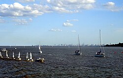
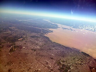
The Río de la Plata, known in English as the River Plate or La Plata River, is a massive funnel-shaped indentation on the southeastern coastline of South America. Formed by the confluence of the Uruguay and Paraná rivers at Punta Gorda, this body of water serves as a vital maritime gateway and a natural border between Argentina and Uruguay.
Depending on the geographical definition used, the Río de la Plata is classified variously as a river, an estuary, a gulf, or a marginal sea. If categorized as a river, it holds the distinction of being the widest in the world, reaching a maximum width of 220 kilometers (140 mi).
Key Facts
- Meaning: Spanish for "River of Silver."
- Maximum Width: 220 kilometers (140 mi).
- Primary Tributaries: Paraná River and Uruguay River.
- Major Cities: Buenos Aires (Argentina) and Montevideo (Uruguay).
- Basin Size: Approximately 3.17 to 3.18 million square kilometers.
- Global Status: The second largest drainage basin in South America.
Geography and Physical Characteristics
The Río de la Plata stretches approximately 290 kilometers (180 mi) in length. It begins as a narrow channel of about 2 kilometers (1.2 mi) at its source and expands dramatically as it flows toward the Atlantic Ocean.
Islands and Shoals
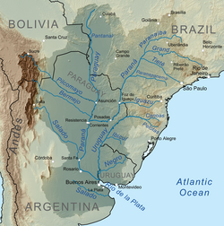
A critical geographical feature is the Barra del Indio, a submerged shoal that effectively splits the water body into two distinct zones. The inner fluvial zone is a freshwater riverine area roughly 180 kilometers long and up to 80 kilometers wide, with depths between 1 and 5 meters. Beyond the shoal lies the outer estuarine zone, where the water becomes brackish (a mix of fresh and salt water) and depths increase to between 5 and 25 meters.
Hydrology and the Platine Basin
The river behaves as an estuary where freshwater from the Paraná and Uruguay rivers mixes with seawater. While tidal ranges are small, the immense width of the river creates a tidal prism—the volume of water moving in and out with tides—that significantly influences the flow regime.
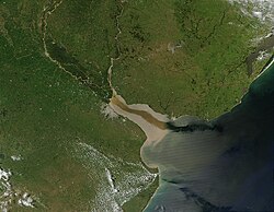
The drainage area, known as the Platine basin, covers roughly one-fourth of the South American continent. This vast hydrographical region includes parts of southeastern Bolivia, southern and central Brazil, the entirety of Paraguay, most of Uruguay, and northern Argentina.
| Feature | Detail |
|---|---|
| Length | 290 km (180 mi) |
| Max Width | 220 km (140 mi) |
| Basin Area | ~3,170,000 to 3,182,064 km² |
| Average Discharge | 22,000 to 27,225 m³/s |
| Mouth | Atlantic Ocean (Argentine Sea) |
Historical Significance
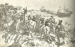
The estuary was first explored by the Portuguese in 1512–13, followed by the Spanish in 1516. Navigator Juan Díaz de Solís initially called it the Mar Dulce ("freshwater sea").
The "River of Silver"
The modern name was coined by explorer Sebastian Cabot between 1526 and 1529. After trading with the Guaraní people near present-day Asunción and hearing legends of a "Sierra de la Plata" (Mountain of Silver), Cabot renamed the waterway Río de la Plata.
Colonial and Revolutionary Eras
Buenos Aires was first founded in 1536 by Pedro de Mendoza, though it was later re-founded by Juan de Garay in 1580. During the colonial period, the region became a hub for trade, particularly silver from the Potosí mines. This trade was often "illicit," bypassing the official Spanish Crown fleet system.
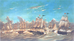
In 1776, the area was elevated to the Viceroyalty of the Río de la Plata. The 19th century was marked by intense conflict over navigation rights and territorial interests, including the Argentine civil wars and the Paraguayan War. Notable naval engagements occurred during the Cisplatine War, such as the Battle of Juncal and the Battle of Monte Santiago.
World War II: The Battle of the River Plate
In December 1939, the estuary hosted the first naval battle of World War II. The German pocket battleship Admiral Graf Spee was engaged by British and New Zealand cruisers. The German vessel eventually sought refuge in Montevideo and was scuttled by its captain to avoid further combat.
Culture and Urbanization
The coasts of the Río de la Plata are among the most densely populated regions in South America. The area is the heart of Rioplatense Spanish and the birthplace of tango culture.
Frequently Asked Questions
Why is it called the "River Plate" in English?
The English name uses the archaic meaning of the word "plate," which was used from the 12th century onwards to refer to silver or gold.
Is the Río de la Plata a river or a sea?
It is debated among geographers. Some call it a river (the widest in the world), while others classify it as an estuary, a gulf, or a marginal sea of the Atlantic Ocean.
What is the Barra del Indio?
It is a submerged shoal that separates the inner freshwater riverine portion of the Río de la Plata from the outer brackish estuarine portion.
Which countries share the Río de la Plata?
The river forms part of the border between Argentina and Uruguay.
What is the Platine basin?
The Platine basin is the massive hydrographical area (over 3 million km²) that drains into the Río de la Plata, covering parts of Brazil, Bolivia, Paraguay, Uruguay, and Argentina.