Paraná Delta: Argentina's Unique Riverine Ecosystem
The Paraná Delta (Spanish: Delta del Paraná) is a vast network of islands and wetlands located in Argentina. Formed by the Paraná River, this alluvial basin—a flood plain where a river deposits sediment as it slows down—stretches across the provinces of Entre Ríos, Santa Fe, and Buenos Aires before finally emptying into the Río de la Plata.
What makes the Paraná Delta globally unique is that it is the only river delta in the world that does not empty into a sea, but rather into another river. Spanning approximately 14,000 square kilometres, the delta begins to form between the cities of Santa Fe and Rosario, where the river splits into multiple arms to create its characteristic island landscape.
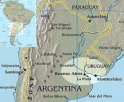
Key Facts
- Total Length: Approximately 320 kilometres (200 mi).
- Basin Size: 14,000 square kilometres (5,400 sq mi).
- Sediment Discharge: 160 million tonnes per year, with about half originating from the Bermejo River.
- Growth Rate: Advances 50 to 90 metres per year into the Río de la Plata.
- Conservation Status: Designated as a Ramsar Wetland on October 3, 2015.
Geography and Regional Divisions
The delta varies in width from 18 to 60 kilometres and is conventionally divided into three distinct sections based on geography:
- Upper Delta: Extends from the Diamante – Puerto Gaboto line to Villa Constitución.
- Middle Delta: Spans from Villa Constitución to the Ibicuy Islands.
- Lower Delta: Extends from the Ibicuy Islands to the mouth of the river.
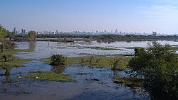
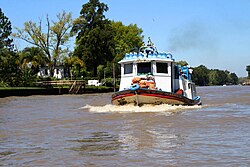
The Lower Delta is particularly significant as it served as the site for the first modern settlements in the Paraná-Plata basin. Today, it is a densely populated region that serves as Argentina's industrial and agricultural core, hosting several major ports. While the main course of the Paraná remains navigable for Panamax-sized ships downstream from Puerto General San Martín, the delta itself is a maze of smaller channels.
Major River Arms
The delta is defined by its complex network of branches. The Paraná Pavón is the first major branch, meandering past the Lechiguanas Islands before being continued by the Paraná Ibicuy. The Ibicuy further gives rise to the Paranacito River, a tributary of the Uruguay River. Other significant arms include the Paraná de las Palmas, the Paraná Guazú, and the smaller Paraná Bravo and Paraná Miní.
Climate and Seasonal Patterns
The Paraná Delta experiences a specific variation of the Pampas climate. Due to the constant presence of water and low elevation, the region enjoys milder winters and higher humidity than the surrounding plains, allowing warmer-weather species to survive.
Summers are typically hot and muggy, with daily highs between 18 and 22 °C, though heat waves can push temperatures to 40 °C. These periods are often interrupted by the Pampero, cool southerly winds that bring temporary relief. Winters (late May to late August) are characterized by cloudiness, fog, and temperatures ranging from 3 to 18 °C, occasionally dropping to -7 °C.
Spring and autumn are generally pleasant, though spring is the season most prone to violent weather and sudden temperature swings. Annual precipitation ranges from 1,000 to 1,400 millimetres, peaking in late spring/early summer and late summer/early fall.
Ecology and Biodiversity
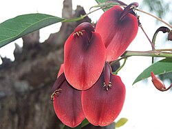
The region is part of the Paraná Delta and Islands Ecoregion. While the original ecosystem—particularly in the Lower Delta—has been impacted by deforestation, pollution, and invasive species, it remains a vital habitat for diverse wildlife. Notable species include the marsh deer, capybara, neotropical river otter, Pampas cat, jaguar, coypu, and the red-faced guan.
Since the 1960s, the delta has hosted large commercial forest plantations. Research indicates that vegetation health (measured by the Normalized Difference Vegetation Index or NDVI) varies throughout the year due to changes in water levels, temperature, photoperiod (the period of time each day during which an organism receives illumination), and the influence of El Niño and La Niña cycles.
Protected Areas and Conservation
To preserve its unique biodiversity, several protected areas have been established:
- Isla Botija Nature Reserve: Established in 1958, it was one of the first protected areas in the Lower Delta.
- Predelta National Park: Created in 1992, this 24.58 square kilometre park protects the Upper Delta's lagoons, swamps, and flood-prone islands.
- Paraná Delta Biosphere Reserve: A UNESCO-declared reserve (2000) covering 886 square kilometres north of Buenos Aires. It focuses on conserving genetic diversity and promoting sustainable growth, such as organic cultivation and certified ecological land-forest production.
| Feature | Detail |
|---|---|
| Total Length | 320 km |
| Total Area | 14,000 sq km |
| Annual Sediment | 160 million tonnes |
| Annual Rainfall | 1,000 - 1,400 mm |
| UNESCO Reserve Area | 886 sq km |
Frequently Asked Questions
What makes the Paraná Delta unique compared to other deltas?
The Paraná Delta is the only river delta in the world that empties into another river (the Río de la Plata) rather than directly into an ocean or sea.
How fast is the delta growing?
The delta advances into the Río de la Plata at a rate of 50 to 90 metres per year, driven by the deposition of 160 million tonnes of suspended sediment annually.
Which animals can be found in the Paraná Delta?
The region hosts a variety of species, including the jaguar, capybara, marsh deer, neotropical river otter, Pampas cat, coypu, and red-faced guan.
What are the three main sections of the delta?
The delta is divided into the Upper Delta (Diamante to Villa Constitución), the Middle Delta (Villa Constitución to the Ibicuy Islands), and the Lower Delta (Ibicuy Islands to the river mouth).
How does the climate in the delta differ from the rest of the Pampas?
While it shares the four seasons of the Pampas, the delta has higher humidity, milder winters, and slightly colder nights due to the ubiquitous presence of water and low elevation.