Paso de los Libres: A Strategic Gateway in Argentine Mesopotamia
Located in the eastern reaches of the Corrientes province, Paso de los Libres serves as a vital urban center within the Argentine Mesopotamia. This city is strategically positioned on the western shore of the Uruguay River, acting as a primary link between Argentina and Brazil.
The city is the head town of the Paso de los Libres department and is characterized by its strong cross-border connections. It is directly opposite the Brazilian city of Uruguaiana in Rio Grande do Sul, with the two connected by the Paso de los Libres-Uruguaiana International Bridge, which supports both road and railway traffic. For air travel, the region is served by the Paso de los Libres Airport.
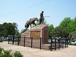
Key Facts
- Foundation: Established on September 12, 1843, by Joaquín Madariaga.
- Population: Approximately 43,251 inhabitants (based on the 2010 census).
- Demonym: Residents are known as libreño or libreña.
- Geography: Situated at coordinates 29°43′S 57°5′W on the banks of the Uruguay River.
- Diplomacy: Hosts a Consulate of Brazil.
City Administration and Infrastructure
Paso de los Libres is governed by a municipal system, currently led by Mayor Martín Ascúa of the Frente de Todos (PJ). The city operates within the UTC−3 time zone (ART) and uses the dialing code +54 3772. Its postal base is identified as W 3320.
The city's infrastructure is heavily influenced by its role as a border hub, facilitating the movement of goods and people between the two South American nations via its international bridge and airport.
Climate and Weather Patterns
The climate in Paso de los Libres is characterized by significant seasonal variation and substantial annual rainfall. The city experiences its warmest temperatures in January, with a record high of 42.5°C (108.5°F), while the coolest temperatures typically occur in July, with record lows reaching −3.5°C (25.7°F).
Precipitation is distributed throughout the year, totaling an average of 1,517.7 mm (59.75 inches) annually. The wettest months are typically April and October, while August tends to be the driest. Humidity remains relatively high year-round, averaging 74.7%.
| Metric | Highest (Jan) | Lowest (Jul) | Annual Average/Total |
|---|---|---|---|
| Mean Daily Maximum Temp | 32.2°C (90.0°F) | 19.0°C (66.2°F) | 25.8°C (78.4°F) |
| Mean Daily Minimum Temp | 20.6°C (69.1°F) | 9.0°C (48.2°F) | 14.9°C (58.8°F) |
| Average Precipitation | 143.9 mm | 68.2 mm | 1,517.7 mm |
| Relative Humidity | 69.7% | 79.7% | 74.7% |
Frequently Asked Questions
Who founded Paso de los Libres?
The city was founded by Joaquín Madariaga on September 12, 1843.
How is Paso de los Libres connected to Brazil?
It is connected to the Brazilian city of Uruguaiana via the Paso de los Libres-Uruguaiana International Bridge, which accommodates both road and rail transport.
What is the population of the city?
According to the 2010 census conducted by INDEC, the city had a total population of 43,251.
What is the typical weather like in Paso de los Libres?
The city has a humid climate with an annual average precipitation of 1,517.7 mm. It experiences hot summers (averaging 32.2°C max in January) and mild to cool winters (averaging 19.0°C max in July).
Is there international diplomatic representation in the city?
Yes, Brazil maintains a Consulate in Paso de los Libres.