Río de la Plata Basin: South America's Vital Hydrographical Network
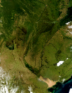
The Río de la Plata basin (also known as the River Plate basin, Platine basin, or Platine region) is one of the most significant hydrographical areas in the world. Spanning approximately 3,170,000 square kilometres (1,220,000 sq mi), this massive system drains into the Río de la Plata and covers roughly one-fourth of the South American continent. It stands as the second-largest drainage basin in South America, surpassed only by the Amazon basin.
This vast region is unique as one of only two river systems globally defined as international waters, crossing the borders of southeastern Bolivia, southern and central Brazil, the entirety of Paraguay, most of Uruguay, and northern Argentina.
Key Facts
- Total Area: 3,170,000 square kilometres.
- Primary Rivers: Río de la Plata, Paraná, Paraguay, and Uruguay rivers.
- Global Standing: Second largest drainage basin in South America.
- Water Discharge: Average of 22,000 cubic metres per second into the Atlantic Ocean.
- Key Resource: Serves as the recharge zone for the Guarani Aquifer.
Geography and Political Reach
The basin is naturally bounded by the Brazilian Highlands to the north, the Andes Mountains to the west, and Patagonia to the south. The watershed extends roughly 2,400 kilometres (1,500 mi) northward from the source of the Río de la Plata, reaching as far as Sucre in Bolivia and Brasília and Cuiabá in Brazil.
Politically, the basin is a complex mosaic of territories. It encompasses several Brazilian states (including São Paulo, Minas Gerais, and Mato Grosso), three Bolivian departments (Santa Cruz, Chuquisaca, and Tarija), the whole of Paraguay, central and western Uruguay, and thirteen Argentine provinces, ranging from Jujuy in the north to La Pampa in the south.
Hydrology and Tributaries
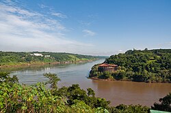
The basin functions as a massive collection system for precipitation, which is channeled through three primary arteries: the Paraná River, the Paraguay River, and the Uruguay River. The Paraná is the largest tributary and ranks as the second-longest river in South America.
The system is ecologically and geologically vital, acting as the recharge zone for the Guarani Aquifer, one of the world's largest underground water systems. Every year, these rivers transport an estimated 57,000,000 cubic metres of silt into the Río de la Plata. Because winds and tides stir up these muddy waters, the shipping lanes leading to Buenos Aires require constant dredging to remain navigable.
Major River Networks
- Paraná River: Fed by the Paranaíba, Grande, Tietê, Paranapanema, Iguazu, Paraguay, and Salado rivers before ending in the Paraná Delta.
- Paraguay River: Flows through the Pantanal wetland and is fed by the Pilcomayo and Bermejo rivers.
- Uruguay River: Fed by the Pelotas, Canoas, Ibicuí, and Río Negro rivers.
- Other: The Salado del Sur River also serves as a significant tributary to the Río de la Plata.
Historical Evolution
The region has historically been a flashpoint for conflict due to its position as the contested frontier between the Spanish and Portuguese Empires. In the 16th century, explorer Sebastian Cabot mapped the area and named the river "Río de la Plata" (River of Silver) after trading for silver trinkets with the Guaraní people.
European colonization began with the founding of Buenos Aires in 1536 by Pedro de Mendoza, though the city was initially abandoned and later refounded by Juan de Garay in 1580. As Portuguese and British interests grew in the 18th century, Spain established the Viceroyalty of the Río de la Plata in 1776 to better manage the region.
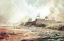
The 19th century was marked by intense instability and warfare over territorial control and navigation rights, including the Argentine Civil Wars, the Cisplatine and Platine wars, and the Paraguayan War.
Economic Infrastructure and Culture
Today, the basin is a powerhouse of hydroelectric energy. It hosts some of the world's largest dams, most notably the Itaipu Dam—the third largest operating facility globally—shared by Paraguay and Brazil.
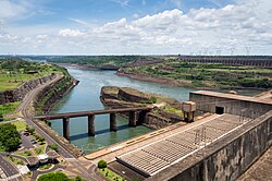
Other significant hydroelectric projects include the Yacyretá Dam (Paraguay and Argentina), the Salto Grande Dam (Uruguay and Argentina), and numerous facilities in Brazil such as the Ilha Solteira and Itumbiara dams.
Culturally, the lower basin is the heart of Rioplatense Spanish, a distinct dialect of the Spanish language. The region is also globally recognized as the birthplace of the tango, both as a musical genre and a dance.
| Feature | Detail |
|---|---|
| Total Area | 3,170,000 km² |
| Primary Countries | Brazil, Argentina, Paraguay, Uruguay, Bolivia |
| Main Rivers | Paraná, Paraguay, Uruguay |
| Major Aquifer | Guarani Aquifer |
| Key Infrastructure | Itaipu Dam, Yacyretá Dam, Salto Grande Dam |
| Cultural Legacy | Tango, Rioplatense Spanish |
Frequently Asked Questions
Why is it called the "River of Silver"?
The name Río de la Plata comes from silver trinkets that explorer Sebastian Cabot acquired while trading with the Guaraní people near present-day Asunción in the 16th century.
Which is the largest river in the basin?
The Paraná River is the largest tributary of the Río de la Plata and is the second-longest river in South America.
What is the significance of the Guarani Aquifer?
The Río de la Plata basin serves as the recharge zone for the Guarani Aquifer, which is one of the largest aquifer systems in the world.
Which hydroelectric dam is the most prominent in the region?
The Itaipu Dam, shared between Brazil and Paraguay on the Paraná River, is the most prominent, ranking as the third largest operating hydroelectric facility in the world.
What cultural contributions originated in the Platine region?
The region is the birthplace of the tango dance and music, and it is where the distinct Rioplatense Spanish dialect is spoken.