Entre Ríos: Argentina's Fertile Heartland Between Rivers
Located in the heart of Argentina's Mesopotamia region, Entre Ríos is a province defined by its geography. Its name, which translates to "Between Rivers," perfectly describes its position, nestled between the massive Paraná River to the west and south and the Uruguay River to the east. This strategic location has shaped its history, economy, and culture, making it a vital hub of agriculture and political significance in the Southern Cone.
The province is bordered by the provinces of Buenos Aires, Corrientes, and Santa Fe, as well as the nation of Uruguay. Its capital, Paraná, serves as a bustling urban center situated directly across the river from the city of Santa Fe. Since 1999, Entre Ríos has collaborated with Córdoba and Santa Fe as part of the Center Region, an economic-political association designed to strengthen the interior of the country.
Key Facts
- Capital: Paraná
- Population: 1,426,426 (2022 Census)
- Total Area: 78,781 km²
- HDI: 0.836 (Very High)
- Economy: 6th largest in Argentina, heavily driven by agriculture and livestock.
- Climate: Humid subtropical (Cfa) with no dry season.
History and Heritage
The region was originally inhabited by the Charrúa and Chaná peoples. European contact began in 1520 when Juan Rodríguez Serrano explored the Uruguay River. While early Spanish attempts at settlement occurred in the late 16th century, the region remained largely indigenous until the late 17th century, when colonists from Santa Fe established settlements at the Bajada del Paraná.
The 19th century was a period of intense political volatility and growth. In 1820, the caudillo (regional military-political leader) Francisco Ramírez declared the territory the autonomous Republic of Entre Ríos. Later, the province played a pivotal role in national politics under Justo José de Urquiza. In 1853, Paraná was named the capital of the Argentine Confederation, and Urquiza became its first president.
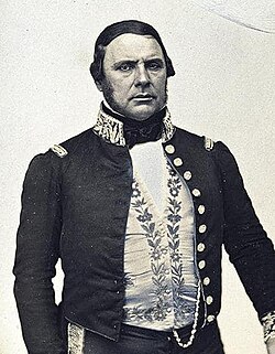
Urquiza was instrumental in transforming the province's demographics through "colonization contracts." He encouraged immigration from Europe, attracting Volga Germans, Russians, Poles, Italians, Swiss, and French settlers to establish agricultural colonies.
Geography and Climate
The landscape of Entre Ríos is predominantly flat, characterized by low hills known as lomadas or cuchillas. The two primary systems are the Cuchilla de Montiel in the west and the Cuchilla Grande in the east, separated by the Gualeguay River.
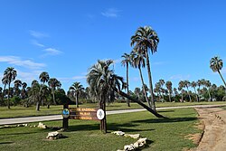
The province is a haven for biodiversity and natural beauty, hosting the Predelta National Park and the El Palmar National Park. Additionally, the Uruguay River basin is famous for its therapeutic hot springs in cities such as Federación and Colón.
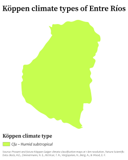
The climate is classified as humid subtropical (Cfa) under the Köppen system. This means the region experiences significant rainfall throughout the year, averaging 1,000 mm or more. Summers are warm and humid, with average maximums of 31°C, while winters are mild, averaging around 13°C.
Economy and Industry
Entre Ríos possesses the sixth-largest economy in Argentina. It is a powerhouse of agricultural production, contributing 60% of the national rice output and serving as the second-largest producer of citrus fruits in the country.
The livestock sector is equally robust, with 4.5 million head of cattle and a growing dairy industry producing nearly 250,000 tons of products annually. The province is also a major contributor to the national poultry and egg markets, providing 37% of chickens and 25% of eggs. Honey production has also emerged as a key export commodity.
Manufacturing accounts for roughly 15% of the economic output, primarily focusing on agro-industrial activities such as flour and rice mills, as well as timber, chemicals, and metallurgy.
Government and Administration
The provincial government operates under a three-branch system: executive, legislative, and judiciary. The executive branch is led by a popularly elected governor, while the legislative branch is bicameral, consisting of the Senate and the Chamber of Deputies.
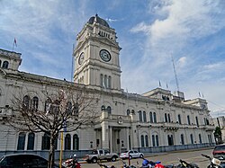
Administratively, the province is divided into 17 departments, each with its own capital city. Law enforcement is managed by the Entre Ríos Provincial Police, supported by the Argentine Federal Police.

Provincial Overview
| Category | Detail |
|---|---|
| Total Area | 78,781 km² |
| Population (2022) | 1,426,426 |
| GDP (2018) | 292 billion pesos (US$11.2 billion) |
| HDI (2021) | 0.836 (Very High) |
| Administrative Divisions | 17 Departments |
Frequently Asked Questions
What does the name "Entre Ríos" mean?
The name is Spanish for "Between Rivers," referring to the province's location between the Paraná and Uruguay rivers.
Which agricultural products is Entre Ríos most famous for?
The province is a leader in rice production (60% of the national total), citrus fruits, soybeans, wheat, maize, and poultry.
Who was Justo José de Urquiza?
Urquiza was a prominent general, politician, and caudillo who served as the first president of the Argentine Confederation and governor of Entre Ríos, notably promoting European immigration to the region.
What is the climate like in Entre Ríos?
It has a humid subtropical climate with no dry season, characterized by warm summers and mild winters, with annual precipitation typically exceeding 1,000 mm.
What are the main natural attractions in the province?
Key attractions include the El Palmar and Predelta National Parks, as well as the thermal hot springs located along the Uruguay River basin.