Rosario-Victoria Bridge: A Vital Link Across the Paraná River
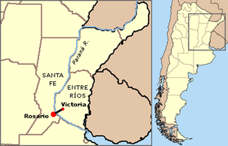
The Rosario-Victoria Bridge serves as a critical transportation artery in Argentina, providing a direct physical connection between the city of Rosario in the province of Santa Fe and the city of Victoria in the province of Entre Ríos. Officially named Nuestra Señora del Rosario, this engineering feat facilitates the movement of people and goods across the expansive Paraná River and its surrounding delta.
Rather than a single structure, the roadlink is a complex system comprising several bridges, viaducts, and earth-filled sections. As it traverses the Paraná Delta, the route touches down on multiple islands before reaching its destination.
Key Facts
- Official Name: Nuestra Señora del Rosario.
- Location: Connects Rosario (Santa Fe) and Victoria (Entre Ríos).
- Total Roadlink Length: 59.4 kilometers (36.9 miles).
- Main Bridge Length: 4,098 meters (13,445 feet).
- Design Type: Cable-stayed bridge (a design where the deck is supported by cables connected to one or more towers).
- Opening Date: May 22, 2003.
- Carries: National Route 174.
Engineering and Construction
Construction of the project began in 1998. However, the timeline was plagued by interruptions due to inconsistent funding from national and provincial governments, particularly during the peak of the Argentine economic crisis in 2001. Despite these setbacks, the bridge officially opened to public transit on May 22, 2003.
Technical Specifications
The total length of the bridges and viaducts combined is 12.2 km (7.6 mi). The centerpiece of the project is the main cable-stayed bridge, which features a central span of 350 meters (1,150 feet) and a clearance of 50 meters (160 feet) below the deck to allow for river navigation.
The scale of the construction is reflected in the massive quantities of materials utilized:
- Concrete: Approximately 250,000 cubic meters.
- Steel: 63,000 tons of ADN-420 type steel.
- Asphalt: 17,618 tons.
Funding and Management
The project was executed by a private firm, Puentes del Litoral S.A., with the support of subsidies from the national government and the provinces of Santa Fe and Entre Ríos, totaling roughly $385 million. In exchange for the investment, the company was granted a 25-year concession for the operation and maintenance of the bridge.
Regional Significance
Before the completion of the Rosario-Victoria Bridge, road travel between these two commercially vital regions was limited. The only other road link was the Hernandarias Subfluvial Tunnel (Uranga-Begnis Tunnel), located approximately 120 kilometers (75 miles) north, connecting Santa Fe and Paraná. To the south, the Zárate-Brazo Largo Bridge provides another cable-stayed crossing linking Entre Ríos with the Buenos Aires province.
The western access point to the main bridge is situated on the northern border of Rosario, meeting the city of Granadero Baigorria.
| Feature | Detail |
|---|---|
| Total Roadlink Distance | 59.4 km (36.9 mi) |
| Combined Bridge/Viaduct Length | 12.2 km (7.6 mi) |
| Main Span Length | 350 m (1,150 ft) |
| Total Main Bridge Length | 4,098 m (13,445 ft) |
| Vertical Clearance | 50 m (160 ft) |
| Steel Used | 63,000 tons (ADN-420) |
Frequently Asked Questions
What is the official name of the Rosario-Victoria Bridge?
The official name of the main cable-stayed bridge is Nuestra Señora del Rosario.
When did the bridge open to the public?
The bridge was opened for public transit on May 22, 2003.
Who was responsible for the construction and maintenance?
The project was executed by the private company Puentes del Litoral S.A., which held a 25-year concession for its operation and maintenance.
What route does the bridge carry?
The bridge carries National Route 174.
Why was the construction of the bridge delayed?
Construction was repeatedly interrupted due to a lack of continued funding from the national and provincial states, specifically during the Argentine economic crisis of 2001.