Levees and Dikes: Engineering Flood Protection and Water Management
A levee is an elevated ridge constructed alongside the banks of a river or along low-lying coastlines. Its primary purpose is to protect adjoining land from flooding by acting as a barrier against rising waters. Depending on the region and terminology, these structures are also known as dikes (common in American and Commonwealth English), floodbanks, or stop banks. Essentially, a levee is a specialized type of embankment designed to regulate water levels and safeguard human settlements.
Levees can be either natural or artificial. Natural levees form organically through the deposition of sediment during flood events, while artificial levees are engineered structures built from fill material. While they provide critical protection, the construction of artificial levees can sometimes lead to environmental challenges by altering natural river processes.
Key Facts
- Purpose: To prevent river or coastal flooding of adjacent low-lying areas.
- Composition: Usually earthen, though they can be reinforced with stone or other materials.
- Types: Natural (formed by sediment deposition) and Artificial (man-made).
- Global Presence: Used since ancient times by civilizations in Egypt, China, Mesopotamia, and the Indus Valley.
- Critical Weakness: A levee is only as strong as its weakest point; consistency in height and construction is vital.
The Origins and Etymology of Water Barriers
The terminology used for these structures reflects a rich linguistic history. The word levee originates from the French levée (from lever, meaning "to raise"), referring to the ridge being raised higher than the surrounding floodplain. This term became prominent in New Orleans shortly after the city's founding in 1718.
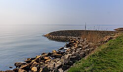
Conversely, the term dike likely derives from the Dutch dijk. In early usage, this word referred to both the trench dug and the bank formed from the excavated soil. This dual meaning persists in some English dialects, where a "dyke" might refer to a drainage ditch or a boundary marker rather than a flood barrier.
How Levees are Formed and Constructed
Natural Levee Formation
Natural levees occur on river floodplains without human intervention. During a flood, as water leaves the main channel, it loses velocity. This causes the river to deposit its coarsest load—sediment and alluvium—immediately adjacent to the channel. Finer sediments settle further away, creating a U-shaped channel with gentle slopes. Over time, repeated flooding builds these ridges, increasing the river's capacity.
Artificial Levee Construction
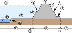
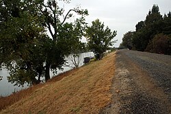
Artificial levees are typically built by piling earth on a cleared, level surface. They are designed with a broad base that tapers to a level top, known as the crown. In emergency situations, temporary levees may be constructed rapidly using sandbags.
To improve safety, engineers often employ specific strategies:
- Set-back Levees: Placing the levee further from the river to create a wider channel.
- Flood Valley Basins: Dividing areas with multiple levees so that a single breach does not flood a massive region.
- Spetchels: Specialized levees made of stones laid in horizontal rows with thin turf between them.
Historical and Modern Applications
Water management has been central to the growth of early civilizations. The Harappan peoples of the Indus Valley (c. 2600 BCE) and the ancient Egyptians—who built a system stretching over 1,000 kilometers along the Nile—relied on levees for agrarian survival. In the 1400s, the city-state of Mēxihco-Tenōchtitlan used a levee to separate fresh potable water from the brackish waters of Lake Texcoco.
In modern times, the Mississippi River levee system is one of the largest in the world. Spanning over 5,600 km, it includes sections that average 7.3 meters in height, with some reaching up to 15 meters. This massive undertaking, often compared to the Great Wall of China, was expanded by the U.S. Army Corps of Engineers to protect vast stretches of the American South.
Levee Failures and Engineering Challenges
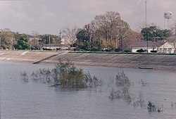
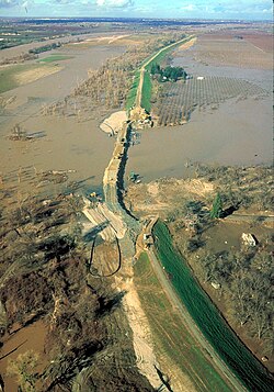
A levee "fails" when water overtops its crest. While overtopping causes flooding, it is less damaging to the structure itself than a breach. Breaches are often caused by soil erosion and scour, which can lead to a complete collapse of the embankment.
To prevent these disasters, engineers use several advanced monitoring and design techniques:
- Erosion Function Apparatus (EFA): Used to measure soil erodibility and simulate water velocity vectors.
- Electrical Resistivity Tomography (ERT): A non-destructive geophysical method that detects critical saturation areas within an embankment to provide early warnings of seepage.
- Exceedance Levels: In the U.S., tolerances are often expressed as a percentage; for example, a "<1% annual chance flood" indicates the levee is designed to resist breaching in 99 out of 100 years.
Summary of Levee Characteristics
| Feature | Natural Levees | Artificial Levees |
|---|---|---|
| Formation | Sediment deposition during floods | Human engineering and fill material |
| Materials | Alluvium, silt, and mud | Earth, stone, or sandbags |
| Primary Goal | Natural channel shaping | Flood protection for human settlements |
| Maintenance | Self-sustaining via aggradation | Requires constant monitoring and repair |
Frequently Asked Questions
What is the difference between a levee and a dike?
In most contexts, they are the same thing: an embankment built to prevent flooding. "Levee" is more common in American English (derived from French), while "dike" is common in Commonwealth English and the Netherlands (derived from Dutch).
How do natural levees form?
They form when a river overflows its banks. As the water slows down, it drops the heaviest sediments first, right next to the river channel. Over many floods, these deposits build up into raised ridges.
What causes a levee to breach?
While overtopping occurs when water flows over the top, a breach is a structural failure. This is most often caused by soil erosion and scour, where the force of the water eats away at the embankment until it collapses.
Can artificial levees be harmful?
Yes, artificial levees can be environmentally damaging. They can disconnect a river from its natural floodplain, altering sediment budgets and potentially increasing the intensity of flood discharge downstream.
How do engineers monitor levee health?
Engineers use tools like Electrical Resistivity Tomography (ERT) to find saturated areas and seepage within the earthworks, allowing them to fix weak points before a breach occurs.