Kocher River: A Journey Through Baden-Württemberg
The Kocher is a significant waterway in the north-eastern region of Baden-Württemberg, Germany. Stretching approximately 169 kilometers (105 miles), this right tributary of the Neckar is defined by its winding nature—a characteristic reflected in its name, which originates from the Celtic word cochan, meaning a meandering river.
The river begins its journey in the eastern foothills of the Swabian Alb, emerging from two distinct karst springs—natural openings in soluble limestone bedrock. These two headwaters, the Schwarzer Kocher and the Weißer Kocher, converge in Unterkochen near Aalen to form the main stem of the river.
Key Facts
- Total Length: 168.7 km (104.8 mi)
- Drainage Basin: 1,960 km² (760 sq mi)
- Source Elevation: 510 m (1,670 ft)
- Mouth: Flows into the Neckar near Bad Friedrichshall
- Primary Tributaries: Lein, Rot, and Bühler
The Headwaters: Black and White Kocher
The river's identity is shaped by its two unique sources. The Schwarzer Kocher (Black Kocher) rises south of Oberkochen. It is approximately 8 km (5.0 mi) long and is characterized by a slower flow and dark-colored water caused by the covered ground. Its discharge is variable, ranging from 50 L/s to 4,000 L/s, with an average of 680 L/s.
In contrast, the Weißer Kocher (White Kocher) rises west of Unterkochen from numerous small sources. Spanning 3.3 km (2.1 mi), it is known for the white foam created as the water rushes quickly over stones. It maintains an average discharge of 400 L/s.
Course and Geography
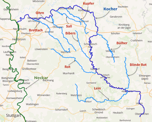
After the two sources join in Unterkochen, the Kocher flows north through Aalen and Wasseralfingen. Upon reaching Hüttlingen, the river turns west toward Abtsgmünd, where it is joined by the Lein river. The waterway continues its winding path northwest to Unterrot, receiving the Rot river before passing through the cities of Gaildorf and Schwäbisch Hall.
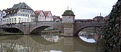
Near Geislingen, the Bühler river enters the system. The Kocher then makes a wide curve back to the west, cutting through the Hohenlohe plain and flowing through Künzelsau. After passing Neuenstadt am Kocher, where the Brettach river joins, the Kocher finally reaches its mouth at the Neckar near Bad Friedrichshall. This confluence occurs just a few kilometers upstream from where the Jagst river, which runs roughly parallel to the Kocher, also enters the Neckar.
Water Quality and Environmental Recovery
The Kocher has faced significant environmental challenges. Due to a concentration of industrial sites in the upper valley and inadequate sewage treatment plants, the river suffered from heavy pollution. By 1984, it was designated as the most polluted river in the Stuttgart administrative district.
However, a dedicated six-year remediation project led to a substantial improvement in water quality. Today, the river is considered only moderately polluted. While the water often appears brown, this is attributed to suspended mud rather than chemical pollution.
River Specifications and Tributaries
The Kocher system is supported by a diverse network of tributaries that feed into its 1,960 km² basin.
| Feature | Details |
|---|---|
| Source | Swabian Alb (510 m elevation) |
| Mouth | Neckar (Bad Friedrichshall) |
| Length | 168.7 km |
| Left Tributaries | Schwarzer Kocher, Aal, Lein, Rot, Bibers, Kupfer, Sall, Ohrn, Brettach |
| Right Tributaries | Weißer Kocher, Blinde Rot, Rötenbach, Eisbach, Adelbach, Bühler, Orlacher Bach, Reichenbach, Ernsbach |
Frequently Asked Questions
What does the name "Kocher" mean?
The name is derived from the Celtic word "cochan," which likely means a winding or meandering river.
Why is the river called the "Black" and "White" Kocher at its source?
The Schwarzer Kocher is named for its dark color caused by the ground it flows over and its slow pace. The Weißer Kocher is named for the white foam produced as it rushes quickly over stones.
Is the brown color of the water a sign of pollution?
No. The predominantly brown color of the Kocher is caused by mud in the water and is not an indicator of poor water quality.
How was the river's pollution addressed?
After being named the most polluted river in the Stuttgart district in 1984, a six-year remediation project was implemented, which successfully improved the water quality to a moderate level.
Where does the Kocher river end?
The Kocher flows into the Neckar river near Bad Friedrichshall, shortly before the Jagst river joins the Neckar.