Gulf of Fonseca
The Gulf of Fonseca (Spanish: Golfo de Fonseca) is a significant body of water in Central America, forming a part of the Pacific Ocean. This strategic gulf is shared among three bordering nations: El Salvador, Honduras, and Nicaragua. Its unique position makes it a vital ecological zone and a focal point of regional geopolitical history.
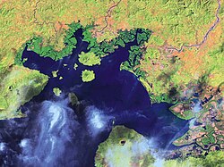
Key Facts
- Location: Central America, bordering El Salvador, Honduras, and Nicaragua.
- Surface Area: Approximately 3,200 km² (1,200 sq mi).
- Coastline: 261 km total, with the largest portion (185 km) belonging to Honduras.
- Climate: Tropical and subtropical with distinct rainy and dry seasons.
- Ecology: Dominated by mangrove forests and volcanic islands.
- Governance: Shared control as determined by the International Court of Justice.
Physical Geography and Climate
The Gulf of Fonseca covers an area of about 3,200 km² (1,200 sq mi). Its 261 km coastline is distributed among the three basin countries: Honduras holds 185 km, Nicaragua holds 40 km, and El Salvador holds 29 km.
The region experiences a tropical and subtropical climate characterized by two primary seasons. The rainy season, spanning from May to November, accounts for nearly 80% of the annual rainfall, which ranges between 1,400 and 1,600 mm (55–63 in). Conversely, the dry season occurs from December to May. During this period, an annual evaporation rate of 2,800 mm (110 in) leads to inward currents from the Pacific Ocean, increased salinity in estuaries, and seasonal droughts.
Average temperatures typically fluctuate between 25 and 30 °C (77–86 °F), peaking in March and April. Relative humidity varies between 65% and 86% depending on the specific location.
Ecosystems and Biodiversity
The wetland ecosystem is dominated by mangroves, which are salt-tolerant trees and shrubs. Six species have been identified in the Gulf, with the red mangrove (Rhizophora mangle) being the most common in permanently inundated areas. The black mangrove (Avicennia germinans) is typically found near river sediment deposits, while the white mangrove (Laguncularia racemosa) and botoncillo (Conocarpus erectus) are found further inland.
The Gulf's tides have an average daily amplitude of 2.3 m (7.5 ft). This cycle creates diverse habitats: low tides expose soils inhabited by conch and crabs, while high tides turn mangrove forests into essential feeding grounds and refuges for shrimp and fish.
Geological Features
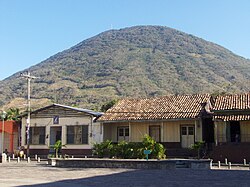
The landscape is marked by volcanic activity, with several volcanoes located within and around the perimeter of the gulf.
Historical and Political Context
European discovery of the bay occurred in 1522 by Gil González de Ávila, who named it after his patron, Archbishop Juan Fonseca.
In 1849, the United States attempted to negotiate a canal across Honduras to connect the Caribbean Sea to the Gulf. This led to a brief diplomatic clash when the British fleet occupied El Tigre Island to protect the British Mosquito Coast. The British eventually withdrew after it was revealed that the island had been temporarily ceded to the United States.
Maritime Disputes and Legal Resolutions
The rights to the Gulf and its islands have been a source of long-standing tension between El Salvador, Honduras, and Nicaragua. In 1917, the Central American Court of Justice ruled in the "Fonseca case" regarding a dispute between El Salvador and Nicaragua. The conflict arose from the Bryan–Chamorro Treaty, which granted the U.S. a portion of the bay for a naval base. Although the court sided with El Salvador, the U.S. ignored the decision.
Later, the United Nations ONUCA mission (starting in 1989) worked to ease international tensions using mobile observer teams patrolling by road, helicopter, and boat.
A definitive resolution came in 1992 when the International Court of Justice (ICJ) ruled on the Land, Island and Maritime Frontier Dispute. The ICJ mandated that the three countries share control of the Gulf. Specifically, El Salvador was awarded the islands of Meanguera and Meanguerita, while Honduras was awarded El Tigre Island.
Summary of Gulf Characteristics
| Feature | Details |
|---|---|
| Total Surface Area | 3,200 km² (1,200 sq mi) |
| Total Coastline | 261 km (162 mi) |
| Annual Rainfall | 1,400–1,600 mm (55–63 in) |
| Average Temperature | 25–30 °C (77–86 °F) |
| Primary Vegetation | Mangroves (Red, Black, White, Botoncillo) |
| Basin Countries | El Salvador, Honduras, Nicaragua |
Frequently Asked Questions
Which countries share the Gulf of Fonseca?
The Gulf of Fonseca is shared by El Salvador, Honduras, and Nicaragua.
How was the dispute over the islands resolved?
The International Court of Justice (ICJ) resolved the dispute in 1992, awarding El Tigre Island to Honduras and the islands of Meanguera and Meanguerita to El Salvador, while ruling that the Gulf itself be shared among the three nations.
What is the dominant vegetation in the Gulf?
The ecosystem is dominated by mangroves, with the red mangrove (Rhizophora mangle) being the most common species.
How does the climate affect the Gulf's waters?
During the dry season (December to May), reduced freshwater inflow and high evaporation rates cause currents to flow inward from the Pacific Ocean, which increases the salinity of the estuaries.
Who discovered the Gulf for Europeans?
The bay was discovered by Gil González de Ávila in 1522.