Cuba Geography and Environmental Overview
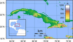
Cuba is a prominent island nation situated in the Northern and Western Hemispheres. While it is part of North America, it is not located on the mainland, instead occupying a strategic position within the North Atlantic Ocean and the Caribbean Sea. As a primary member of the Antilles—specifically the Greater Antilles—Cuba serves as a central geographic hub in the region.
The nation's physical layout is characterized by an extensive coastline and a diverse range of natural landscapes, from coastal plains to rugged mountain peaks.
Key Facts
- Highest Point: Pico Turquino at 1,974 meters (6,476 ft).
- Total Area: 110,861 square kilometers.
- Coastline Length: 3,735 kilometers.
- Population: Approximately 11,268,000, making it the 85th most populous country globally.
- Time Zone: UTC-05 (Standard) and UTC-04 (Summer).
Physical Geography and Environment
Cuba's environment is defined by its varied ecoregions—distinct areas of land characterized by specific climate and biological communities—and its designated biosphere reserves. The island's topography ranges from the sea-level Caribbean coast to the heights of the interior mountains.
Natural Features and Water Bodies
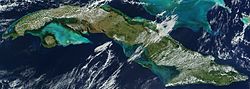
The island is surrounded by a complex network of gulfs and bays that are vital to its geography. Notable water bodies include the Bay of Havana, the Bay of Pigs, the Bay of Matanzas, the Bay of Cárdenas, the Bay of Santa Clara, and the Ensenada de la Broa. Additionally, the coastline is shaped by the Gulf of Batabanó, the Gulf of Cazones, the Gulf of Guacanayabo, and Guantánamo Bay.
Beyond the coast, the interior is marked by various rivers and mountain ranges, contributing to a rich biodiversity of flora (plant life) and fauna (animal life), including diverse species of birds, mammals, amphibians, and reptiles.
Geographic Summary Table
| Feature | Detail |
|---|---|
| Region | Greater Antilles, Caribbean |
| Highest Elevation | Pico Turquino (1,974 m) |
| Lowest Elevation | Caribbean Sea (0 m) |
| Total Area | 110,861 km² |
| Coastline | 3,735 km |
Administrative Divisions and Regions
Cuba is organized into several administrative divisions, primarily consisting of provinces and municipalities. The national capital is Havana.
Provinces and Capitals
The country is divided into the following provinces and their respective capitals:
- Camagüey: Camagüey
- Ciego de Ávila: Ciego de Ávila
- Cienfuegos: Cienfuegos
- Granma: Bayamo
- Guantánamo: Guantánamo
- Holguín: Holguín
- Matanzas: Matanzas
- Pinar del Río: Pinar del Río
- Sancti Spíritus: Sancti Spíritus
- Santiago de Cuba: Santiago de Cuba
- Las Tunas: Victoria de Las Tunas
- Villa Clara: Santa Clara
- Ciudad de La Habana: No provincial capital (National Capital)
- La Habana: No provincial capital
Frequently Asked Questions
What is the highest point in Cuba?
The highest point in Cuba is Pico Turquino, which reaches an elevation of 1,974 meters (6,476 ft).
Which region of the world is Cuba located in?
Cuba is located in the Northern and Western Hemispheres, specifically within the Greater Antilles of the Caribbean and the North Atlantic Ocean.
How long is the coastline of Cuba?
Cuba has a coastline extending 3,735 kilometers.
What are some of the major bays in Cuba?
Major bays include the Bay of Havana, the Bay of Pigs, the Bay of Matanzas, and Guantánamo Bay, among others.
How is Cuba administratively divided?
Cuba is divided into provinces and municipalities, with Havana serving as the national capital.