West Indies: Geography, History, and Geology of the Caribbean Region
The West Indies is a vast and diverse island subregion of the Americas, nestled between the North Atlantic Ocean and the Caribbean Sea. Comprising 13 independent nations and 18 dependencies, this region is a complex tapestry of archipelagos, cultures, and geological wonders. While the term is often used interchangeably with "Caribbean," the West Indies specifically encompasses the islands of the Antilles, as well as The Bahamas, Bermuda, and the Turks and Caicos Islands.
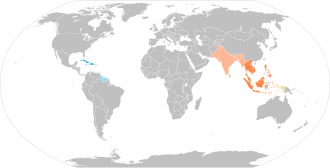
Key Facts
- Total Area: 239,681 km² (92,541 sq mi)
- Population: Approximately 44,182,048
- Political Structure: 13 independent countries and 18 dependencies
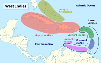
- Major Archipelagos: Greater Antilles, Lesser Antilles, and Lucayan Archipelago
- Primary Languages: Spanish, English, French, Dutch, and various Creoles
Etymology and Historical Context
The name "Indies" has deep linguistic roots, derived from the Classical Latin India, which refers to the territories in South Asia near the Indus River. When Christopher Columbus arrived in the Americas in 1492, he mistakenly believed he had reached the eastern edges of the existing Indies in Asia. To distinguish between the two regions, explorers eventually categorized them as the East Indies (Asia) and the West Indies (the Americas).
Historically, the West Indies was a site of intense colonial competition. In the late 16th century, French, English, and Dutch merchants began challenging Spanish and Portuguese dominance. This era saw the rise of the Sugar Revolution in the mid-17th century, which brought thousands of enslaved Africans to the region to work in sugar fields and mills. This period fundamentally transformed the demographics of the islands, creating a rich, multi-ethnic society composed of Indigenous, African, European, and Asian descendants.
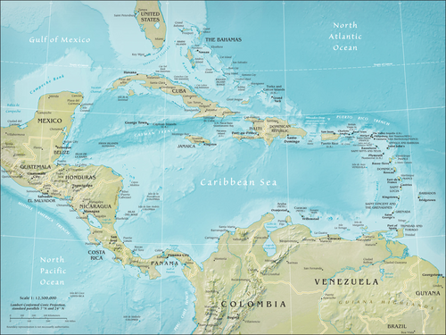
Geological Composition and Archipelagos
The West Indies is a geologically complex system of approximately 7,000 islands and islets stretching over 3,000 km. The region is divided into three distinct geological groups:
The Greater Antilles
The oldest of the three archipelagos, the Greater Antilles includes the largest islands: Cuba, Hispaniola, Jamaica, and Puerto Rico. These islands feature the region's highest mountains, such as Pico Duarte. Their composition varies from ancient Precambrian remains to Jurassic limestone and volcanic rock formed by the collision of tectonic plates.
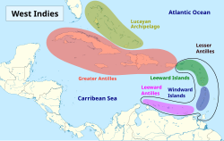
The Lesser Antilles
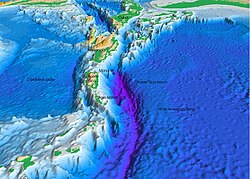
The Lesser Antilles is a volcanic island arc created by the subduction—the process where one tectonic plate sinks beneath another—of the North American and South American plates beneath the Caribbean Plate. This activity produces both active volcanoes and deep oceanic trenches, such as the Puerto Rico Trench.
The Lucayan Archipelago
Consisting of The Bahamas and the Turks and Caicos Islands, this archipelago is characterized by low-lying islands and barrier reefs sitting atop the Bahama Platform, a carbonate block fixed to the North American plate.
Demographics and Culture
The West Indies is home to a vibrant, multicultural population. Ethnic groups include Afro-Caribbean, Latin-Caribbean, Indo-Caribbean, White-Caribbean, Mixed-Caribbean, Asian-Caribbean, and Indigenous peoples. This diversity is reflected in the region's languages, which include Spanish, English, French, Dutch, and several Creoles and Papiamento.
Religion plays a significant role in the social fabric, with Christianity being the most prominent faith. Specifically, Catholicism accounts for 52.3% of the population, while Protestantism makes up 20.2%. Other significant groups include those with no religious affiliation (20.6%), Hindu practitioners (2.1%), and followers of folk religions (2.5%).
Regional Summary
| Category | Details |
|---|---|
| Total Countries | 13 |
| Total Dependencies | 18 |
| Major Languages | Spanish, English, French, Dutch, Creoles |
| Primary Religions | Christianity (73.5%), No Religion (20.6%) |
| Population Density | 151.5/km² |
Frequently Asked Questions
What is the difference between the West Indies and the Caribbean?
While the terms are often used interchangeably, "West Indies" specifically refers to the island groups (the Antilles and the Lucayan Archipelago), whereas "Caribbean" can also include the mainland coastal regions of Central and South America.
Why is the region called the West Indies?
The name originated because Christopher Columbus believed he had reached the "Indies" of Asia by sailing west. To distinguish the new lands from the East Indies in Asia, the term "West Indies" was adopted.
What causes the volcanic activity in the Lesser Antilles?
The volcanic activity is caused by the subduction of the North American and South American plates beneath the Caribbean Plate, which creates intense geological pressure and heat.
Which islands are part of the Greater Antilles?
The Greater Antilles include the largest islands in the region: Cuba, Hispaniola, Jamaica, and Puerto Rico.
What are the main languages spoken in the West Indies?
The region is linguistically diverse, with Spanish, English, French, and Dutch being major languages, alongside various Spanish, French, English, and Dutch Creoles, as well as Papiamento.