Ariake Sea: Kyushu's Largest Bay
Located on the island of Kyūshū in Japan, the Ariake Sea (Ariake-kai) is a remarkable body of salt water that serves as a vital geographical and economic hub. Surrounded by the prefectures of Fukuoka, Saga, Nagasaki, and Kumamoto, it stands as the largest bay in the region, characterized by its shallow waters and dramatic tidal shifts.
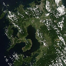
Geography and Physical Characteristics
The Ariake Sea is defined by its unique physical profile. Despite its size, the bay is relatively shallow, with its deepest point reaching only about 20 meters. It covers an area of approximately 1,700 square kilometres (660 sq mi) and is known for its extreme tides, which can exceed 4 meters (13 ft).
The bay's complex coastline includes Isahaya Bay as a branch, while the Yatsushiro Sea lies across the Amakusa Islands. The landscape is further influenced by volcanic activity; Mount Unzen overlooks the sea, and the Arie River, which originates on this volcano, flows directly into the bay.
Maritime Infrastructure and Connectivity
Due to its strategic location, the coast of the Ariake Sea is dotted with numerous harbors that facilitate trade and transport. Key harbors include:
- Misumi (Uki, Kumamoto Prefecture)
- Shimabara and Taira (Nagasaki Prefecture)
- Nagasu, Kumamoto, and Oniike (Kumamoto Prefecture)
- Miike (Omuta, Fukuoka Prefecture)
- Kuchinotsu (Minamishimabara, Nagasaki Prefecture)
To connect these coastal communities, five distinct ferry routes operate across the sea.
The Unique Ecosystem of the Tidal Flats
One of the most defining features of the Ariake Sea is its extensive network of tidal flats—coastal wetlands that are exposed during low tide. These flats are naturally replenished by volcanic ash carried from Mount Aso and Mount Kujū via the Chikugo River.
Biodiversity and Flora
The nutrient-rich environment supports a variety of specialized fauna and flora, including:
- Mudskippers and fiddler crabs, which are adapted to amphibious life.
- Pen shells (Atrina pectinata).
- Shichimenso (Suaeda japonica), a halophyte—a salt-tolerant plant—that grows along the shore during autumn.
Culture and Recreation
The tidal flats are not only ecologically important but also a source of local pride and entertainment. Every year around the end of May, the flats at Kashima host the Gatalympics, a novelty sports event where participants compete in the mud.
Economy and Environmental Challenges
The Ariake Sea is a powerhouse for aquaculture (the farming of aquatic organisms), with nori (edible seaweed) being one of its primary products. However, the region also experiences a mysterious optical phenomenon known as Shiranui, where lights appear along the coast resembling fire.
Despite its productivity, the sea faces significant environmental pressures. In recent years, increasing pollution has led to the occurrence of red tides, which are harmful algal blooms that can deplete oxygen in the water. Additionally, there is ongoing land reclamation—the process of creating new land from the sea—which continues despite government efforts to discourage farmers from the practice.
Ariake Sea Quick Facts
| Feature | Details |
|---|---|
| Location | Kyūshū, Japan (Fukuoka, Saga, Nagasaki, Kumamoto) |
| Maximum Depth | Approximately 20 meters |
| Tidal Range | Exceeds 4 meters (13 ft) |
| Total Area | Roughly 1,700 square kilometres (660 sq mi) |
| Major Product | Nori (Seaweed) |
| Key Geological Influence | Volcanic ash from Mt. Aso and Mt. Kujū |