Argentina Geography: A Diverse Landscape of Andes and Pampas
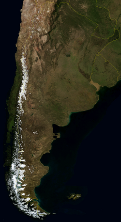
Argentina is a land of staggering geographic diversity, stretching from the subtropical forests of the north to the subantarctic reaches of the south. As the second-largest country in South America and the eighth largest in the world, it encompasses a vast array of terrains, including the towering peaks of the Andes, fertile plains known as the pampas, and an extensive network of rivers and lakes.
Bordered by the South Atlantic Ocean to the east and the Andes Mountains to the west, Argentina occupies a strategic position in the Southern Hemisphere. Its territory serves as a critical link between the Atlantic and Pacific oceans via the Strait of Magellan and the Beagle Channel.
Key Facts
- Total Area: 2,780,400 km², ranking 8th globally.
- Highest Point: Cerro Aconcagua, reaching 6,960 meters.
- Lowest Point: Laguna del Carbón at -105 meters.
- Longest River: The Paraná River, spanning 4,700 km.
- Coastline: 4,989 km along the South Atlantic.
- Population: 46.6 million (as of 2010).
Regional Landscapes and Terrain
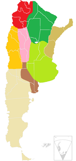
Argentina's geography is categorized into several distinct regions, each defined by its unique climate and topography.
The Andes and Cuyo
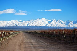
The western border is dominated by the Andes, the longest mountain range in the world. Within this range lies Aconcagua, the highest peak in both Argentina and South America. The Cuyo region, located in the middle-west, is characterized by an arid climate and is divided into the uniform occidental range and the more varied oriental range. This area is famous for its snow-melt irrigation, supporting agriculture in an otherwise dry environment.
The Pampas and Mesopotamia
The Pampas are the fertile plains of central Argentina, encompassing provinces like Buenos Aires and Córdoba. To the east lies the Mesopotamia region, situated between the Paraná and Uruguay rivers. This area is largely a plain that drains into the Río de la Plata Basin.
Gran Chaco and the Northwest
The north is home to the Gran Chaco, a flat region characterized by subtropical climates, swamps, and xerophilous forests (plants adapted to dry conditions). The Argentine Northwest features the Puna—a high, treeless plateau with salt pans—as well as wetter hills and valleys.
Patagonia
The southern region, Patagonia, is known for its cold winters, heavy snowfall in the mountains, and vast glacial landscapes. It contains the majority of the country's large lakes and the southernmost point of the mainland at Cape San Pío.
Water Resources and Hydrography
Argentina's water systems are classified by their drainage patterns. Exorheic watersheds drain into the sea (such as the Paraná and Uruguay rivers), while endorheic watersheds drain internally (such as the Atuel River). Areic watersheds lack drainage entirely.
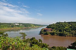
The Paraná River is the nation's longest, eventually joining the Uruguay River to form the Río de la Plata estuary. The country is also home to the Iguazu Falls, one of the largest waterfall systems globally, located on the border with Brazil.
Lakes and Marine Zones
Most major lakes, including Lake Buenos Aires and Lake Argentino, are located in Patagonia. Mar Chiquita in Córdoba stands as the largest saltwater lake. Beyond the coast, Argentina maintains an exclusive economic zone of 1,159,063 km² in the Argentine Sea.
Climate and Environment
The climate varies significantly by latitude. The north experiences hot, wet summers and mild, drier winters. Central Argentina is prone to thunderstorms and some of the world's largest hail. The south is characterized by warm summers and cold, snowy winters.
Forest cover currently accounts for approximately 10% of the land area. As of 2020, this totaled 28,573,000 hectares, with the vast majority being naturally regenerating forest.
National Parks and Conservation
Argentina manages a network of thirty national parks, ranging from Baritú in the north to Tierra del Fuego in the south. Established formally in 1934, the system protects diverse biotopes (distinct areas of uniform environmental conditions). Notable parks include Nahuel Huapi and Iguazú, which were among the first to be formalized to protect borders and preserve native flora and fauna.
| Feature | Detail |
|---|---|
| Global Area Rank | 8th |
| Land vs Water | 98.43% Land / 1.56% Water |
| Primary Borders | Chile, Bolivia, Paraguay, Brazil, Uruguay |
| Arable Land | 13.9% |
| Forest Cover | 10.7% (2020) |
| Highest Peak | Cerro Aconcagua (6,960m) |
Frequently Asked Questions
What is the highest point in Argentina?
The highest point is Cerro Aconcagua, located in the Mendoza Province, which reaches an elevation of 6,960 meters, making it the highest peak in South America.
Which is the longest river in Argentina?
The Paraná River is the longest river in the country, extending 4,700 km before forming the Río de la Plata estuary.
How is the Argentine territory divided regionally?
The country is divided into several key zones: the Argentine Northwest, Gran Chaco, Mesopotamia, Cuyo, the Pampas, and Patagonia.
What are the characteristics of the Puna region?
The Puna is a high, treeless plateau in the Northwest characterized by salt pans and very limited water resources, mostly consisting of temporary streams.
What is the significance of the Strait of Magellan?
The Strait of Magellan is a strategic waterway that provides a vital link between the Atlantic and Pacific oceans, located near the southern tip of Argentina.