AntarcticaAntarctic TreatySouth Poleclimate changeozone depletion

Antarctica: The Frozen Frontier of Science and History

Antarctica: The Frozen Frontier of Science and History Antarctica is the southernmost continent, a vast expanse of ice and rock that serves as one of the most critical laboratories for un...

Antarctica: The Frozen Frontier of Science and History

Antarctica is the southernmost continent, a vast expanse of ice and rock that serves as one of the most critical laboratories for understanding Earth's past and future. Covering approximately 14.2 million square kilometers, it is a land of extremes, characterized by its isolation, freezing temperatures, and a unique legal status that prioritizes scientific cooperation over national sovereignty.

Historically viewed as a mysterious landmass known as Terra Australis Incognita (Unknown Southern Land), Antarctica remained hidden from human eyes for millennia. Today, it is a hub for international research, hosting a seasonal population that fluctuates from 1,300 in the winter to 5,100 in the summer.
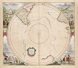
17th century map of the Antarctic region
A speculative representation of Antarctica labelled as 'Terra Australis Incognita' on Jan Janssonius's Zeekaart van het Zuidpoolgebied (1657), Het Scheepvaartmuseum

Key Facts

  • Total Area: 14,200,000 km² (5,500,000 sq mi).
  • Population: Seasonal, ranging from 1,300 to 5,100 residents.
  • Highest Point: Vinson Massif.
  • Governance: Managed by the Antarctic Treaty; no single country owns the continent.
  • Primary Use: Scientific research and controlled tourism.
  • Internet TLD: .aq

Geography and Geology

The continent is broadly divided by the Transantarctic Mountains, which separate Eastern Antarctica from Western Antarctica. The landscape is dominated by massive ice sheets, though it also contains the Vinson Massif, the highest peak on the continent.
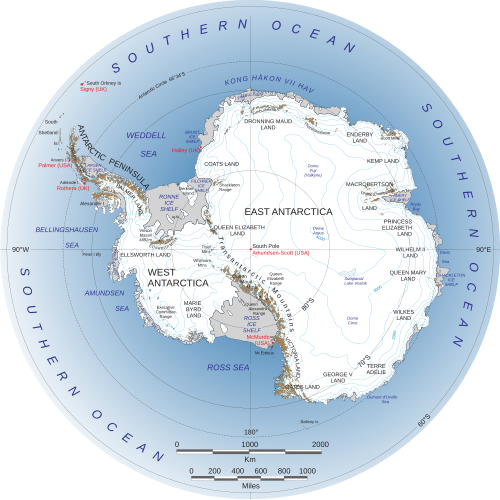
map of Antarctica
Eastern Antarctica is to the right of the Transantarctic Mountains and Western Antarctica is to the left.

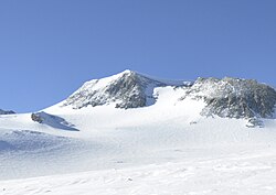
photograph of Vinson Massif
Vinson Massif from the northwest, the highest peak in Antarctica

Geologic Evolution

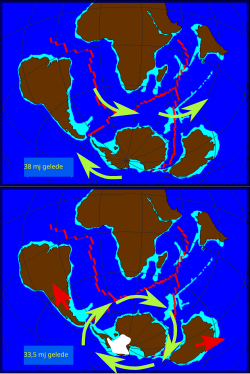
Antarctica was once part of the supercontinent Gondwana. Its geologic history is marked by a series of fragmentations: the first occurred around 150 million years ago (Ma), followed by a second at 126 Ma, and a final separation at 83 Ma. This breakup led to the formation of the Antarctic Circumpolar Current, which thermally isolated the continent and contributed to its current glacial state.
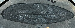
Glossopteris sp. leaf from the Permian of Antarctica

Formation of the Antarctic Circumpolar Current from the final fragmentation of the Antarctic land bridge

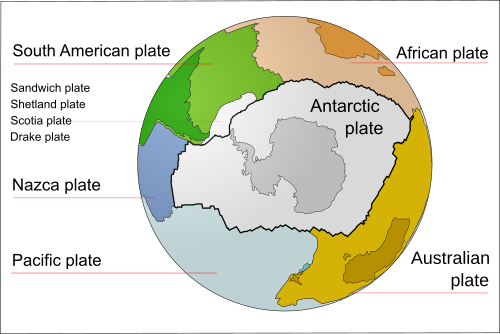
map of the tectonic plates of the southern hemisphere
The Antarctic Plate

Climate and Environmental Challenges

Antarctica is the coldest place on Earth, though regional differences exist. While the interior is characterized by extreme freezes, some coastal areas can experience more temperate conditions during the December summer.

Climate Change and the Ozone Layer

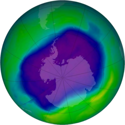
The continent is a primary indicator of global climate change. Satellite observations from NOAA have tracked surface ice layer temperature trends, revealing significant shifts. One of the most pressing environmental issues is ozone depletion, where a hole in the ozone layer—the region of the stratosphere that absorbs most of the sun's ultraviolet radiation—forms over the continent, reaching record sizes such as that seen in September 2006.
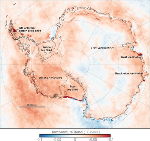
Antarctic surface ice layer temperature trends between 1981 and 2007, based on thermal infrared observations made by a series of NOAA satellite sensors.

Image of the ozone hole spanning almost all of Antarctica
Image of the largest hole in the ozone layer recorded, in September 2006

Biodiversity and Conservation

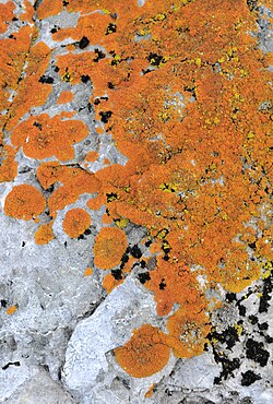
Despite the harsh conditions, Antarctica supports a specialized array of life. The most iconic residents are the Emperor penguins, but the ecosystem also includes fungi, lichens, and a very limited number of flowering plants.
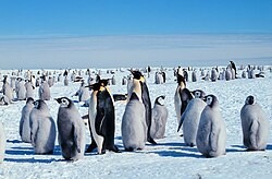
penguins with young
Emperor penguins with juveniles

lichen photographed in Antarctica
An orange lichen (perhaps Caloplaca) growing on the Yalour Islands, Wilhelm Archipelago

Flora and Fauna

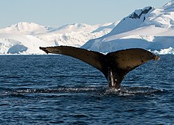
Native flowering plants are extremely rare; only two species exist, including Deschampsia antarctica and the Antarctic pearlwort. The surrounding Southern Ocean is a rich habitat for whales and other marine mammals, protected in part by the Southern Ocean Whale Sanctuary.
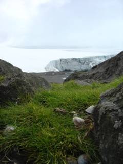
Deschampsia antarctica at Collins Glacier, Antarctica. This species is one of only two flowering plants native to Antarctica, the other one being Antarctic pearlwort.

photograph of a whale in the Southern Ocean
A whale in the Southern Ocean Whale Sanctuary

Environmental Protection

To protect this pristine environment, the Madrid Protocol was established to ensure the continent is used for peaceful purposes and scientific research. Efforts are ongoing to combat pollution, such as the refuse littering shorelines seen in earlier decades.
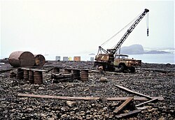
photograph of refuse on an island in Antarctica
Refuse littering the shoreline at Bellingshausen Station on King George Island, photographed in 1992

History of Exploration and Politics

The race to the South Pole was one of the great adventures of the early 20th century. Early records of the "Farthest South" progressed from Ferdinand Magellan in 1521 to James Cook in the 18th century, and eventually to Roald Amundsen, who reached the South Pole in 1911.
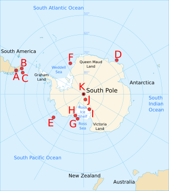
Positions of Farthest South records: pre-1521 possibly by Yaghan people (B), 1521 by Ferdinand Magellan (A), 18th century by James Cook (D/E), early 19th century by James Weddell (F) and James Clark Ross (G) and around the turn to the 20th century from 1900 by Carsten Borchgrevink (H), after landing and setting up base for the first time on Antarctica, to Roald Amundsen reaching the South Pole in 1911 (K).

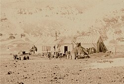
The first base on Antarctica of Carstens Borchgrevink's Southern Cross Expedition (1899). The hut (HSM 22) still stands and is located on Cape Adare, the cape where in 1895 Borchgrevnik participated in the first documented landing on Antarctica.

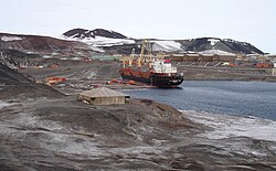
Discovery Hut (1902) at Hut Point Peninsula of Ross Island, Antarctica, one of the earliest repeatedly temporarily used dwellings on Antarctica. In the background McMurdo Station, the largest base on Antarctica today, with cargo operations of the supply ship MV American Tern of Operation Deep Freeze 2007.

The Antarctic Treaty and Territorial Claims

Several nations have made territorial claims to parts of Antarctica, including France, the UK, New Zealand, Norway, Australia, Chile, and Argentina. However, the Antarctic Treaty, signed in 1959, effectively froze these claims to prevent conflict and ensure the continent remains a zone of peace and science.
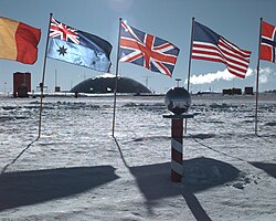
photograph of the South Pole research station
The "ceremonial" South Pole, at Amundsen–Scott Station

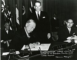
photograph of the US signing the Antarctic Treaty
The U.S. delegate Herman Phleger signs the Antarctic Treaty in December 1959.

Map of the Spanish Governorate of Terra Australis (1539–1555), the first territorial claim over the lands near the South Pole.[7][192]

Summary of Territorial Claims in Antarctica
Claimant Territory Year of Claim Limits/Notes
France Adélie Land 1840 142°2′ E to 136°11′ E
United Kingdom British Antarctic Territory 1908 80°0′ W to 20°0′ W (Overlaps with Chile/Argentina)
New Zealand Ross Dependency 1923 160°0′ E to 150°0′ W
Norway Queen Maud Land / Peter I Island 1931/1939 20°00′ W to 44°38′ E
Australia Australian Antarctic Territory 1933 44°38′ E to 160°00′ E
Chile Chilean Antarctic Territory 1940 90°0′ W to 53°0′ W (Overlaps with UK/Argentina)
Argentina Argentine Antarctica 1943 74°0′ W to 25°0′ W (Overlaps with UK/Chile)
Unclaimed Marie Byrd Land N/A 150°0′ W to 90°0′ W

Modern Antarctica: Research and Tourism

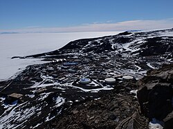
Today, Antarctica is defined by its research stations. McMurdo Station stands as the largest settlement, supporting a wide array of scientific endeavors from astronomy to the study of meteorites.
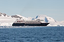
Photograph of a cruise ship off the Antarctic coast
The cruise ship Silver Cloud in Wilhelmina Bay

aerial photograph of McMurdo station
An aerial view of McMurdo Station, the largest research station in Antarctica

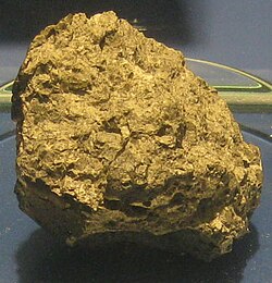
Photograph of a meteorite found in Antarctica
An Antarctic meteorite, Allan Hills 84001 on display at the Smithsonian Museum of Natural History

Frequently Asked Questions

Who owns Antarctica?

No single country owns Antarctica. While seven nations have made territorial claims, the Antarctic Treaty of 1959 sets aside the continent as a scientific preserve and prohibits new claims or the expansion of existing ones.

What is the "ozone hole"?

The ozone hole is a region of severe depletion of the ozone layer in the stratosphere over Antarctica. This allows more harmful ultraviolet radiation to reach the Earth's surface.

Are there any native plants in Antarctica?

Yes, but very few. There are only two native flowering plant species: Deschampsia antarctica and the Antarctic pearlwort.

What is the purpose of McMurdo Station?

McMurdo Station is the largest research base on the continent and serves as a primary logistics and science hub for the United States Antarctic Program.

How did Antarctica become so cold?

The separation of Antarctica from Gondwana and the subsequent formation of the Antarctic Circumpolar Current isolated the continent from warmer ocean currents, leading to its extreme cooling and glaciation.

References

  1. The word was originally pronounced with the first c silent in English, but the spelling pronunciation has become common and is often considered more correct. However, the pronunciation with a silent c, and even with the first t silent as well, is widespread and typical of many similar English words.[2][failed verification] The c had ceased to be pronounced in Medieval Latin and was dropped from the spelling in Old French, but it was added back for etymological reasons in English in the 17th century and thereafter began to be pronounced, but (as with other spelling pronunciations) at first only by less educated people.[3] For those who pronounce the first t, there is also variation between the pronunciations Ant-ar(c)tica and An-tar(c)tica.
  2. Before the Southern Ocean was recognised as a separate ocean, it was considered to be surrounded by the southern Pacific, Atlantic, and Indian Oceans.[13]
  3. Geographical features, such as ice caps, are shown as they are today for identification purposes, not as how they appeared at these times.
  4. The feature discovered by the Russians was the Fimbul ice shelf.
  5. Ross passed through what is now known as the Ross Sea and discovered Ross Island (both of which were named after him) in 1841. He sailed along a huge wall of ice that was later named the Ross Ice Shelf.[166] Mount Erebus and Mount Terror are named after two ships from his expedition: HMS Erebus and Terror.[167]