Alb-Donau District: A Hub of Nature and History in Baden-Württemberg
Located in the heart of southwestern Germany, the Alb-Donau-Kreis is a diverse district (Landkreis) within the state of Baden-Württemberg. Situated in the administrative region of Tübingen, this area is defined by its stunning natural landscapes and its strategic position surrounding the city of Ulm. From the rolling hills of the Swabian Jura to the banks of the Danube, Alb-Donau blends rural charm with administrative importance.
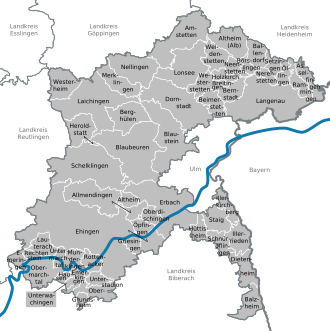
The district serves as a vital link between various regions, bordering the districts of Biberach, Reutlingen, Göppingen, and Heidenheim, as well as the Bavarian districts of Günzburg and Neu-Ulm. While the city of Ulm serves as the administrative capital, it remains a separate entity and is not technically part of the district itself.
Key Facts
- State: Baden-Württemberg, Germany
- Administrative Region: Tübingen
- Capital: Ulm (Administrative seat)
- Total Area: 1,357.32 km²
- Population: 202,354 (as of December 31, 2024)
- Population Density: 149.083 people per km²
- District Administrator: Heiner Scheffold
Geography and Natural Landscape
The district derives its name from two dominant geographical features: the Danube River and the Swabian Jura (Schwäbische Alb), a highland plateau known for its unique karst topography. The Danube enters the district from the southwest, flowing through the southern regions before reaching Ulm to the east.
Parallel to the river, the Swabian Jura mountains rise to the north, stretching from the southwest to the northeast. Additionally, the Iller River, a significant tributary of the Danube, defines the southeastern border of the district before merging with the Danube in Ulm.
History and Administration
The historical identity of Alb-Donau is deeply intertwined with the legacy of the Swabian Jura and the Free Imperial City of Ulm. The current administrative structure was established in 1973 through a significant merger. This reorganization combined the former districts of Ulm and Ehingen, along with specific municipalities from the Biberach and Münsingen districts.
Heraldry and Symbolism
The district's coat of arms is inherited from the former district of Ulm and carries deep historical meaning. It features an eagle, the heraldic animal of the Free Imperial City of Ulm. The shield also incorporates the deer antlers of Württemberg and the red and white stripes representing the Austrian county of Burgau, reflecting the diverse territorial history of the southern region.
Towns and Municipalities
Alb-Donau is composed of a variety of urban centers and rural communities. The district is divided into recognized towns and smaller municipalities that maintain the region's cultural heritage.
| Category | Details |
|---|---|
| Major Towns | Blaubeuren, Dietenheim, Ehingen, Erbach, Laichingen, Langenau, Munderkingen, Schelklingen |
| Key Municipalities | Allmendingen, Altheim, Amstetten, Blaustein, Dornstadt, Lonsee, Nellingen, etc. |
| Administrative Seat | Ulm |
| Time Zone | CET (UTC+1) / CEST (UTC+2) |
Frequently Asked Questions
Is the city of Ulm part of the Alb-Donau district?
No, the city of Ulm is not part of the Alb-Donau district, although it serves as the district's administrative seat and is completely surrounded by it.
When was the Alb-Donau district formed?
The district was established in 1973 through the merger of the former districts of Ulm and Ehingen, as well as parts of the Biberach and Münsingen districts.
What are the primary geographical features of the region?
The region is characterized by the Danube River, which flows through the south, and the Swabian Jura mountains, which run parallel to the river to the north.
What does the district's coat of arms represent?
The coat of arms features an eagle (representing the Free Imperial City of Ulm), deer antlers (representing Württemberg), and red and white stripes (representing the Austrian county of Burgau).
What is the current population of Alb-Donau?
As of December 31, 2024, the total population of the district is 202,354.