Adrien de Pauger: The Architect of New Orleans and the French Quarter
The enduring charm of the Vieux Carré, known today as the French Quarter, is not a product of chance but of meticulous 18th-century engineering. Adrien de Pauger (ca. 1682/1685 – 1726) was the French engineer and cartographer whose vision defined the layout of New Orleans and influenced the early development of the French Colonial Empire in North America.
The Blueprint of New Orleans
In 1720, Jean-Baptiste Le Moyne de Bienville appointed de Pauger to design the plans for a new city. Arriving at the settlement on March 29, 1721, de Pauger completed the city plan later that year. This blueprint was a critical milestone in establishing a permanent French presence in the region.
De Pauger was responsible for more than just the grid; he selected many of the iconic street names that remain famous today, including Bourbon Street and Royal Street. This original street plan continues to define the geography of the French Quarter in the modern era.
To bring this vision to life, de Pauger worked alongside Pierre Le Blond de La Tour, Bienville's chief engineer. The construction of the settlement relied on impressed slave labor, governed by the Code Noir—the legal framework defining the conditions of enslaved people in the French Colonial Empire. To combat the swampy terrain, they utilized water-resistant cypress wood for the construction of raised cottages.
Strategic Vision and Maritime Influence
Beyond urban planning, de Pauger was a strategic thinker regarding trade and governance. At the time, Biloxi, Mississippi, served as the primary seaport for the French colonies. However, de Pauger successfully lobbied Bienville to move the seat of government from Biloxi to New Orleans.
As a member of the "superior council" overseeing the Louisiana colonies, de Pauger advocated for the creation of a deep-water port in New Orleans. His surveys of the mouth of the Mississippi River indicated that certain regions were deep enough to accommodate ships drawing fifteen feet of water. While the port was established later, his foresight opened a vital seaway for exporting agricultural products from the middle of the Mississippi River Valley.
Expanding the French Footprint: Mobile and Beyond
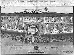
De Pauger's expertise was not limited to Louisiana. In 1725, he applied the lessons learned from New Orleans to design the early settlement of Mobile, Alabama. This project included the design of Fort Condé, a fortification built to defend the new settlement.
The Saint Louis Parish Church
One of de Pauger's most significant architectural contributions was the 1724 plan for the Saint Louis Parish Church in New Orleans. The Roman Catholic Church had established a parish in the area starting in 1720, and the church was built according to de Pauger's design, with its dedication occurring on Christmas Eve in 1727.
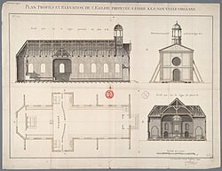
Though the original structure was destroyed during the Great New Orleans Fire of 1788 on March 21, its replacement eventually became the renowned St. Louis Cathedral.
Key Facts
- Role: French engineer and cartographer who designed the Vieux Carré (French Quarter).
- Key Contributions: Named Bourbon and Royal Streets; designed the original map of New Orleans.
- Infrastructure: Advocated for a deep-water port in New Orleans for ships drawing 15 feet of water.
- Other Works: Designed the early settlement of Mobile, Alabama, and Fort Condé.
- Architecture: Designed the original Saint Louis Parish Church (dedicated 1727).
- Legacy: Pauger Street in New Orleans is named in his honor.
| Project | Location | Year/Period | Key Feature |
|---|---|---|---|
| Vieux Carré Plan | New Orleans, LA | 1721 | Original street grid and naming |
| Saint Louis Parish Church | New Orleans, LA | 1724 (Plan) | Foundation for St. Louis Cathedral |
| Mobile Settlement | Mobile, AL | 1725 | City layout and Fort Condé |
| Deep Water Port | New Orleans, LA | Early 1720s (Proposal) | 15-foot draft capacity for exports |
Legacy and Death
Adrien de Pauger died on June 9, 1726. Per his request, it is believed he was buried in the then-incomplete Saint Louis Parish Church. Today, his name lives on through Pauger Street in New Orleans. This street serves as a continuation of Bourbon Street, extending from the Faubourg Marigny through Faubourg Treme before merging with Cameron Boulevard at Filmore Avenue in the Gentilly section of the city.
Frequently Asked Questions
Who designed the layout of the French Quarter in New Orleans?
The layout of the Vieux Carré, or French Quarter, was designed by the French engineer and cartographer Adrien de Pauger in 1721.
Which famous New Orleans streets were named by Adrien de Pauger?
De Pauger selected several of the city's most famous street names, including Bourbon Street and Royal Street.
What was de Pauger's contribution to the city of Mobile, Alabama?
In 1725, de Pauger designed the early settlement of Mobile, which included the construction of Fort Condé for the settlement's defense.
What happened to the original Saint Louis Parish Church designed by de Pauger?
The original church was destroyed by fire on March 21, 1788, during the Great New Orleans Fire. It was later replaced by the St. Louis Cathedral.
Why did de Pauger want to move the government seat from Biloxi to New Orleans?
De Pauger believed New Orleans was a superior location due to its potential for a deep-water port; his surveys showed the mouth of the Mississippi River could accommodate ships drawing fifteen feet of water.