Wyckoff Heights: A History of Urbanization and Identity
Wyckoff Heights stands as a unique intersection of geography and identity, straddling the border between Brooklyn and Queens. Once a sprawling expanse of farmland, the area underwent a gradual transformation into a dense urban neighborhood, reflecting the broader growth of New York City from the late 19th century through the mid-20th century.
The Urbanization of the Wyckoff Farmlands
The neighborhood derives its name from the Wyckoff family, who originally owned and farmed the majority of the land. Urbanization began in the late 1800s as portions of the family farm were sold, allowing development to push outward from Brooklyn into Queens. This transition from rural to residential was marked by the establishment of essential civic infrastructure.
In 1890, the city announced the creation of a new park in the 18th Ward of Brooklyn, which is known today as Maria Hernandez Park. As the population grew, residents took proactive steps to modernize their surroundings. In 1892, property owners in Queens formed the Wyckoff Heights Improvement Association to lobby for the installation of gas, sewer, and water services. This effort led to the creation of the Wyckoff Heights Water Company the following year to ensure a reliable supply of drinking water.
By 1901, the need for organization became critical. Residents in the Queens section petitioned the city government to implement a formal system of house numbering and to install street signs, a necessary step for the postal service to begin official mail delivery to the neighborhood.
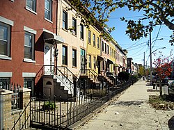
The transition to a fully urban landscape was completed over several decades, with the final 18 acres (approximately 73,000 square meters) of farmland being developed in the 1940s.
Key Facts
- Origin: Named after the Wyckoff family, the original landowners.
- Infrastructure: The Wyckoff Heights Water Company was established in 1893.
- Parks: Maria Hernandez Park was first announced in 1890.
- Development: The last remaining farmland was developed in the 1940s.
- Postal Shift: The Queens section transitioned to ZIP Code 11385 in 1980.
The Complex History of ZIP Codes and Neighborhood Identity
The administrative history of Wyckoff Heights is closely tied to its postal identity. Initially, mail for the Queens section was handled by the Brooklyn Post Office. In 1951, the Wyckoff Heights Post Office opened at 86 Wyckoff Avenue with ZIP Code 11237, serving north Bushwick and the Brooklyn portion of the neighborhood.
When the ZIP Code system was formally assigned in 1963, any area routed through a Brooklyn post office received the 112 prefix. This meant that the Queens neighborhoods of Glendale and Ridgewood shared the 11227 ZIP Code with Bushwick and Wyckoff Heights. Additionally, some parts of Bushwick and Wyckoff Heights fell under 11237.
This shared identity became a point of contention following the 1977 New York City blackout. Widespread reports and photographs from the Associated Press and UPI depicted looting and violence in Bushwick. Consequently, residents of Ridgewood and Glendale sought to distance their communities from the negative reputation associated with Bushwick.
In response to these complaints, Postmaster General William Bolger stated that ZIP Codes could be changed if United States Representative Geraldine Ferraro could prove that 70% of residents supported the move. A ballot distribution revealed that 93% of responding residents favored the change. On January 13, 1980, the Queens side was officially assigned ZIP Code 11385. This change eliminated ZIP Code 11227 and left 11237 to cover only Bushwick and Wyckoff Heights.
| Period/Event | Queens Section ZIP | Brooklyn Section ZIP | Key Change |
|---|---|---|---|
| Pre-1963 | N/A | N/A | Mail routed via Brooklyn Post Office |
| 1963 - 1980 | 11227 | 11237 / 11227 | Shared Brooklyn prefix (112) |
| Post-January 13, 1980 | 11385 | 11237 | Queens section dissociated from Brooklyn prefix |
Frequently Asked Questions
Who were the Wyckoff family?
The Wyckoff family were the original owners and farmers of the land that now comprises the Wyckoff Heights neighborhood.
When was the last farmland in Wyckoff Heights developed?
The final 18 acres (73,000 square meters) of farmland were developed in the 1940s.
Why did the ZIP Codes in the area change in 1980?
Residents of Ridgewood and Glendale in Queens wanted to disassociate themselves from the reputation of Bushwick following the riots and looting during the 1977 New York City blackout.
What was the result of the ZIP Code vote?
After ballots were distributed by Representative Geraldine Ferraro's office, 93% of the returned ballots voted in favor of changing the ZIP Code for the Queens section.
What is the current ZIP Code for the Brooklyn portion of Wyckoff Heights?
The Brooklyn portion of Wyckoff Heights is covered by ZIP Code 11237.