Western Kentucky Tornado: A Detailed Analysis of a Violent Supercell Event
On a devastating evening in December, a powerful supercell—a highly organized thunderstorm with a rotating updraft—spawned a violent, long-tracked tornado that tore through Western Kentucky. This storm followed a path of destruction that spanned multiple counties, exhibiting rapid intensification and catastrophic wind speeds that left entire communities in ruins.
The event began at 8:54 p.m. CST in Woodland Mills, Obion County, Tennessee. Initially rated EF0, the tornado caused minor damage to roofs and trees before crossing the state line into Kentucky. While the initial impact in Tennessee was estimated at $25,000 in damages, the storm was merely in its nascent stage before evolving into a massive, deadly wedge tornado.
Key Facts
- Peak Intensity: High-end EF4 with estimated winds of 190 mph (310 km/h).
- Highest Measured Gust: 120.1 mph (193.3 km/h) recorded at a Kentucky mesonet station.
- Human Toll: Significant fatalities in Mayfield (22), Dawson Springs (14), and Bremen (11).
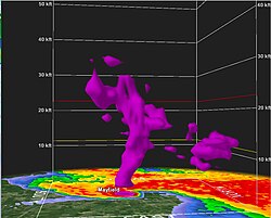
- Maximum Debris Height: Radar detected debris lofted over 30,000 feet (9.1 km) in the air.
- Duration: Touched down at 8:54 p.m. CST and dissipated at 11:48 p.m. CST.
Path of Destruction and Intensification
The Impact on Mayfield
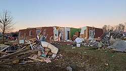
As the tornado approached Mayfield, the National Weather Service issued a tornado emergency. The storm regained EF4 intensity, leveling homes and debarking trees. One of the most tragic strikes occurred at the Mayfield Consumer Products candle factory, where the collapse of a large metal-framed warehouse resulted in eight deaths. The tornado's winds peaked at 188 mph (303 km/h) within the city, destroying three large churches and sweeping numerous residences from their foundations.
Marshall, Lyon, and Caldwell Counties
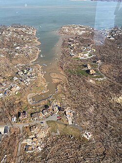
After leaving Mayfield, the tornado fluctuated between EF2 and EF3 strength. It caused significant damage in Benton and Briensburg before reaching EF4 intensity again in Cambridge Shores. Here, large lakeside houses were swept away and the local fire department lost its roof.
The storm then entered Caldwell County, where it explosively intensified. In Princeton, the tornado destroyed the University of Kentucky Research Center and several homes in the Princeton Golf and Country Club subdivision. A Kentucky mesonet station recorded a wind gust of 120.1 mph, the highest ever measured in Kentucky history, shortly before being destroyed.
Catastrophic Damage in Dawson Springs and Bremen
Dawson Springs and Barnsley
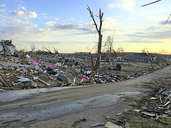
The tornado reached EF4 intensity again as it entered Dawson Springs. Entire blocks of homes were reduced to rubble, and the Dawson Village apartment complex was destroyed. The intensity was so great that a photograph from a destroyed home was lofted by updrafts and discovered nearly 130 miles away in New Albany, Indiana.
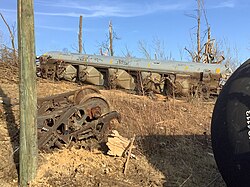
Continuing northeast, the storm struck Barnsley, where it derailed a CSX train, tossing 25 multi-ton freight cars from the tracks, including one that landed inside a house.
The Peak in Bremen
The tornado reached its absolute peak intensity of high-end EF4 in Bremen, with estimated winds of 190 mph (310 km/h). In some areas, such as Bethlehem Cemetery Road, four homes were completely swept away, leaving only the foundations. This section of the storm claimed 11 lives, including District Judge Brian Crick.
Final Stages and Dissipation
The tornado weakened as it entered Ohio County, though it experienced a final surge of EF3 strength near Hartford. It destroyed several chicken houses, tossed tractor-trailers 40 yards, and swept away poorly anchored homes. The storm finally dissipated at 11:48 p.m. CST near Rough River Dam State Resort Park in Grayson County.

Summary of Regional Impacts
| Location | Peak Rating | Key Damage/Impact | Fatalities |
|---|---|---|---|
| Mayfield | EF4 | Candle factory collapse, 3 churches destroyed | 22 |
| Princeton | EF4 | UK Research Center destroyed, record wind gust | 4 |
| Dawson Springs | EF4 | Residential blocks leveled, apartment complex destroyed | 14 |
| Barnsley | EF3/EF4 | CSX train derailment (25 cars) | N/A |
| Bremen | High-end EF4 | Homes swept from foundations, 190 mph winds | 11 |
The EF5 Debate
Following the event, several experts questioned if the tornado actually reached EF5 intensity (winds over 200 mph). A 2022 report by Timothy Marshall and other engineers suggested that the rating might have been higher if the storm had encountered more wind-resistant structures. Marshall noted that some buildings were poorly constructed, making it impossible to determine if EF5 winds were present. Additionally, a 2025 paper from the National Severe Storms Laboratory suggested that the EF5 threshold should be lowered to 190 mph, which would categorize the Mayfield tornado as an EF5.
Frequently Asked Questions
What was the highest wind speed recorded during the tornado?
The highest officially measured wind gust was 120.1 mph (193.3 km/h), recorded by a Kentucky mesonet station before it was destroyed. However, estimated peak winds in Bremen reached 190 mph (310 km/h).
Why is there a debate about whether it was an EF4 or EF5 tornado?
Experts argue that the lack of high-quality, wind-resistant construction in some hit areas made it difficult to prove EF5 wind speeds. Some researchers believe the storm's intensity was EF5-level, but the structures it hit were too frail to provide the necessary forensic evidence.
How far was debris carried by the storm?
The tornado's updrafts were incredibly powerful, lofting debris to an altitude of 30,000 feet. In one remarkable instance, a photograph from a home in Dawson Springs was carried approximately 130 miles to New Albany, Indiana.
Which areas suffered the most fatalities?
The highest death tolls occurred in Mayfield (22 deaths), Dawson Springs (14 deaths), and Bremen (11 deaths).
What is a "wedge tornado" as mentioned in the report?
A wedge tornado is a large tornado that is at least as wide as it is tall, often appearing as a massive wall of debris and clouds, typically associated with very violent intensity.