Uptown New Orleans Historic District
Uptown is a storied section of New Orleans, Louisiana, situated on the east bank of the Mississippi River. Spanning the area between the French Quarter and the Jefferson Parish line, it is a vibrant tapestry of mixed residential and small commercial properties. The region is most celebrated for its wealth of 19th-century architecture, much of which is preserved within the Uptown New Orleans Historic District, a site officially listed on the U.S. National Register of Historic Places since July 3, 1985.
Historically, the area served as a cultural divide; Canal Street was once the boundary between the predominantly Francophone (French-speaking) downtown and the predominantly Anglophone (English-speaking) uptown. While the Central Business District was the earliest area designated as "Uptown," the modern definition encompasses a broad swath of the city's upriver territory.
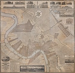
Key Facts
- NRHP Status: Added to the National Register of Historic Places on July 3, 1985.
- Architectural Styles: Features mid-19th-century Revival, late Victorian, and 20th-century Revival styles.
- Geography: Located on the east bank of the Mississippi River, extending toward the Jefferson Parish line.
- Key Landmarks: Includes St. Charles Avenue, Audubon Park, Tulane University, and Loyola University.
- Historical Roots: Developed from former Colonial-era plantations and several independent towns.
Early History and Development
Uptown evolved during the 19th century from land that previously served as plantations. Much of the area originally belonged to Jefferson Parish and was developed as a series of separate towns and faubourgs (suburbs or outskirts), including Lafayette, Jefferson City, Greenville, and Carrollton.
The demographic makeup of Uptown has long been diverse. In addition to settlers from other U.S. states, immigrants from Ireland, Germany, and Italy settled here. The area has also maintained a significant African American population, with census data indicating that racially and ethnically mixed city blocks were common throughout the 19th and early 20th centuries.
The Annexation Process
New Orleans and Orleans Parish gradually absorbed these outlying communities. The City of Lafayette was the first to be annexed in 1852. This was followed in 1870 by the annexation of Jefferson City, Hurstville, Bloomingdale, Burtheville, Greenville, and the land that would eventually become Audubon Park. Finally, Carrollton was annexed in 1874.
The Former Independent Towns
The City of Lafayette
Lafayette began as a settlement at a steamboat landing. In 1833, the Livaudais Plantation was subdivided and incorporated as the City of Lafayette, which included the land now known as the Garden District. The town served as the original seat of the Jefferson Parish courthouse.
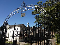
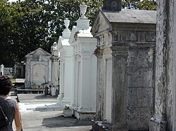
One of its most enduring legacies is Lafayette Cemetery No. 1, established in 1833. While added to the National Register of Historic Places in 1972, the cemetery has faced significant preservation challenges. In 2010, the Louisiana Landmarks Society named it one of the nine most endangered landmarks in New Orleans due to improper maintenance and damage from tree roots and film crews.
Hurstville, Bloomingdale, and Jefferson City
Faubourg Hurstville was the first faubourg of the current Uptown area, created in 1833 by businessman Cornelius Hurst. Hurst named several streets after his family: Eleonore, Arabella, and Joseph. Nearby, Faubourg Bloomingdale was created in 1841. By 1850, several other faubourgs—including Plaisance, Delachaise, and Rickerville—merged to form Jefferson City.
Burtheville and Carrollton
Burtheville was created in 1851 from farmland owned by Dominique François Burthe. It was home to the U.S. Marine Hospital (built in 1858), which later evolved into the U.S. Public Health Service Hospital and eventually the New Orleans Adolescent Hospital.
Carrollton, incorporated in 1845 and annexed in 1874, retains a distinct identity to this day. An interesting quirk of the area's history is the street naming: Lowerline Street is actually located upriver from Upperline Street, a result of the different boundaries of the suburbs annexed during the 1850s.
Cityscape and Infrastructure
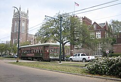
The visual identity of Uptown is defined by its relationship to the river and its grand avenues. St. Charles Avenue, famous for its historic streetcar line, was known as "millionaires row" in the 19th century and still features numerous significant mansions.
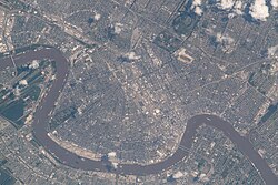
The area is also home to major educational institutions, including Tulane University and Loyola University, which sit adjacent to one another along St. Charles Avenue.
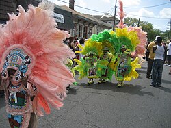
Cultural traditions remain central to the area's appeal, with Mardi Gras Indians, second lines, and Carnival parades continuing to be a staple of Uptown life.
Impact of Hurricane Katrina
Because much of Uptown is situated on higher ground, the majority of the district experienced minimal flooding during Hurricane Katrina. This riverfront strip was colloquially referred to as "the Sliver by the River" or the "Isle of Denial."
However, areas closer to Claiborne Avenue suffered severe flooding. Many historic homes in these sections were built on piers (raised foundations) between 0.9 and 1.2 meters high. Unfortunately, floodwaters rose an additional 30 to 60 cm, overwhelming these protections. This event marked the worst flooding the area had seen since Sauvé's Crevasse in 1849.
Uptown Summary Table
| Category | Details |
|---|---|
| NRHP Listing Date | July 3, 1985 |
| Primary Architectural Styles | Victorian, mid-to-late 19th/20th-century Revivals |
| Key Neighborhoods | Garden District, Carrollton, Central City, Irish Channel |
| Major Institutions | Tulane University, Loyola University, Audubon Park |
| Defining Thoroughfare | St. Charles Avenue |
Frequently Asked Questions
What is the difference between Uptown and the Garden District?
While the Garden District is a specific neighborhood within the broader Uptown area, "Uptown" generally refers to the larger section of New Orleans located upriver from Canal Street, encompassing several neighborhoods including Carrollton and Central City.
Why is the street naming in Carrollton confusing?
The anomaly where Lowerline Street is upriver from Upperline Street occurred because the two streets were originally the boundaries of different suburbs that were annexed by New Orleans at different times.
What is the significance of St. Charles Avenue?
St. Charles Avenue was the "millionaires row" of the 19th century and is home to one of the city's most famous streetcar lines and a high concentration of architecturally significant mansions.
How did Hurricane Katrina affect Uptown?
The riverfront areas (the "Sliver by the River") largely escaped flooding due to higher elevation. However, areas closer to Claiborne Avenue experienced severe flooding that topped the pier foundations of many historic homes.
What is Lafayette Cemetery No. 1?
Established in 1833, it is a historic cemetery listed on the National Register of Historic Places. It has been recognized as an endangered landmark due to maintenance issues and environmental damage.