Ulleungdo: The Volcanic Gem of the Sea of Japan
Located 120 kilometers east of the Korean Peninsula in the Sea of Japan, Ulleungdo is a striking volcanic island known for its steep cliffs, rich biodiversity, and deep historical roots. Formerly referred to in Europe as Argonaut Island or Dagelet Island, this rocky outpost serves as the heart of Ulleung County in South Korea's North Gyeongsang Province.
The island is essentially the peak of a massive stratovolcano—a cone-shaped volcano built up by many layers of hardened lava and tephra—that rises from the ocean floor. With a maximum elevation of 984 meters at Seonginbong Peak, the island spans approximately 9.5 kilometers in length and 10 kilometers in width, covering a total area of 72.86 square kilometers.
Today, Ulleungdo is a vibrant destination where tourism and fishing drive the local economy. The port of Dodong serves as the primary gateway for visitors arriving by ferry from the mainland. The island is particularly famous for its squid harvest, with the sight of squid drying in the sun becoming a characteristic image of the local landscape.
Key Facts
- Highest Point: Seonginbong Peak (984 meters).
- Geography: A volcanic island composed of trachyte, andesite, and basalt.
- Population: Approximately 9,191 inhabitants (as of September 2020).
- Climate: Humid subtropical, characterized by cloudy winters and heavy rainfall.
- Unique Feature: The Nari Basin, the island's only flat surface and a rare double volcano structure.
History and Settlement
Archaeological evidence suggests that humans first inhabited Ulleungdo during the 1st millennium BC. The first confirmed historical record appears in the Samguk sagi for the year 512, detailing the conquest of the autonomous nation of Usan-guk by the Silla general Kim Isabu. Legend suggests Kim Isabu used wooden lions to intimidate the locals into surrendering.
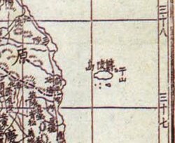
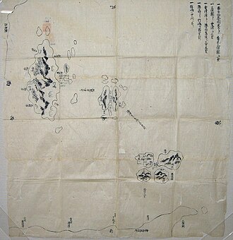
The island's political status shifted over the centuries. While initially conquered by Silla, it did not become a permanent part of Korea until its annexation by Goryeo in 930. Throughout the late Goryeo and early Joseon dynasties, the island faced frequent raids from Jurchen and Wokou pirates. In the 1690s, the Korean fisherman An Yong-bok played a pivotal role in a clash with Japan over fishing rights.
To mitigate these conflicts, the Joseon government implemented an "empty-island" policy to discourage settlement. However, this was difficult to enforce and was officially rescinded in 1881 to encourage permanent habitation. In the 19th century, the waters around the island also attracted American whaleships hunting right whales between 1848 and 1892.
Geology and Climate
Ulleungdo formed during the Cenozoic period through hot spot volcanic activity. It is primarily composed of trachyandesite rock. A massive explosive eruption around 8000 BCE removed the volcano's summit, creating a caldera—a large cauldron-like hollow that forms shortly after the emptying of a magma chamber.
The northern part of the island features the Nari Basin, a unique caldera floor. Within this basin, further volcanic activity created Albong (egg peak), resulting in a rare double volcano structure. The island's geological history is linked to other formations in the region, including the Liancourt Rocks and various seamounts.
The climate is classified as humid subtropical (Köppen Cfa). It shares more similarities with the west coast of Japan than with mainland Korea, particularly regarding its cloudy winters and significant precipitation. The wettest year on record was 2003, with 2,236.9 millimeters of rainfall.
| Metric | Winter (Jan) | Spring (Apr) | Summer (Jul) | Autumn (Oct) | Annual Average |
|---|---|---|---|---|---|
| Mean Daily Max (°C) | 4.4 | 15.1 | 25.5 | 18.8 | 16.0 |
| Mean Daily Min (°C) | -0.5 | 7.8 | 20.5 | 13.0 | 10.1 |
| Avg Precipitation (mm) | 117.4 | 97.8 | 175.0 | 100.9 | 1,480.6 |
Flora and Fauna
Due to its rich biodiversity, the island and its surrounding waters were designated as a marine protected area in 2014. Ulleungdo is home to several endemic species—plants or animals found nowhere else on Earth. These include the rowan tree Sorbus ulleungensis and the beech tree Fagus multinervis, the latter of which was identified as endemic through 2024 genetic analysis.
The surrounding waters have historically been a habitat for North Pacific right whales, fin whales, minke whales, and dolphins. While the Japanese sea lion once bred on the island, it is now extinct. On land, a 2013 study estimated that the island supports approximately 1,177 different insect species.
Tourism and Landmarks
Visitors to Ulleungdo typically enjoy hiking, fishing, and sampling hoe (Korean raw fish). Popular activities include three-hour sightseeing boat tours departing from Dodong Harbor, which showcase coastal rock formations and the nearby island of Jukdo.
Key landmarks include:
- Seonginbong: The island's highest peak, offering panoramic views.
- Chotdaebawi Rock: A 30-meter-high basalt column resembling a candle.
- Bongnae Waterfall: A scenic natural water feature.
- The Natural Icehouse: A unique geological curiosity.
To improve accessibility, an airport has been under construction since 2020. Following a 2023 redesign to accommodate larger aircraft, the airport is expected to open in 2027.
Frequently Asked Questions
What is the highest point on Ulleungdo?
The highest point is Seonginbong Peak, which reaches an elevation of 984 meters (3,228 ft).
What is the Nari Basin?
The Nari Basin is a caldera floor in the northern part of the island. It is the only flat surface on Ulleungdo and features a rare double volcano structure due to the presence of Albong (egg peak).
How do visitors typically reach the island?
Most visitors arrive via ferry at the port of Dodong, which serves as the main link between Ulleungdo and the South Korean mainland.
What are some of the endemic species found on the island?
Endemic species include the rowan tree (Sorbus ulleungensis) and the beech tree (Fagus multinervis).
When is the new airport expected to open?
The airport, which underwent a design revamp in 2023 for larger aircraft, is expected to open in 2027.