The Ninth Ward: A Comprehensive History of a New Orleans Landmark
The Ninth Ward is a distinctive and geographically expansive region of New Orleans, Louisiana. Located in the easternmost downriver portion of the city, it stands as the largest of the city's 17 wards. Bounded by the Mississippi River to the south and Lake Pontchartrain to the north, the ward is a tapestry of diverse neighborhoods, from the riverfront charm of Bywater to the sprawling landscapes of New Orleans East.
While often discussed as a single entity, the Ninth Ward is a complex area that spans several city planning districts (7, 8, 10, and 11). It has been home to legendary figures across music, sports, and the arts, including music icon Fats Domino, NBA player Eldridge Recasner, NFL star Marshall Faulk, and the renowned Batiste musical family.
Key Facts
- Geography: The largest of New Orleans' 17 wards, bounded by the Mississippi River and Lake Pontchartrain.
- Divisions: Broadly split into the Lower 9th Ward, Upper 9th Ward, and Eastern New Orleans.
- Major Landmarks: Includes the Holy Cross neighborhood, Jackson Barracks, and the Michoud Assembly Facility.
- Historical Significance: Site of Ruby Bridges' integration of William Frantz Elementary School in 1960.
- Environmental Impact: Suffered catastrophic flooding during Hurricanes Betsy (1965) and Katrina (2005).
Regional Divisions and Neighborhoods
The Ninth Ward is geographically divided by two major waterways: the Industrial Canal (which separates the Upper and Lower sections) and the Gulf Intracoastal Waterway / Mississippi River Gulf Outlet (MRGO).
The Lower 9th Ward
The smallest section, located south and east of the canals, the Lower 9th Ward is known for its strong community ties. Historically, it boasted the highest percentage of Black homeownership in New Orleans. Key sites include the Holy Cross neighborhood, the Jackson Barracks, and the twin Doullut Steamboat Houses.
The Upper 9th Ward
Located west of the Industrial Canal, this area includes the riverfront neighborhood of Bywater. Further inland lie the Desire and Florida neighborhoods. This section historically contained the Desire and Florida housing projects, as well as the Agriculture Street Landfill—a former city dump that later became a Superfund toxic cleanup site.
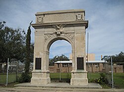
Eastern New Orleans
The largest portion of the ward lies east of the Industrial Canal and north of the MRGO. This expansive area is commonly referred to as New Orleans East.
Historical Evolution
Development began along the riverfront in the early 19th century, followed by the natural highlands of the Gentilly Ridge. The official designation of the "9th Ward" was established in 1852 during a city government reorganization. For decades, the lakefront was dotted with fishing camps, most notably the Little Woods collection, which persisted until Hurricane Georges in 1998.
The ward's history is marked by both social progress and environmental struggle. During the era of racial segregation, Lincoln Beach served as an amusement park for Black residents, while Pontchartrain Beach served white residents.
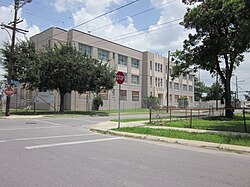
Civil Rights Milestone
In 1960, the Ninth Ward became a focal point of the American Civil Rights Movement when Ruby Bridges became the first Black student to integrate the all-white William Frantz Elementary School. Today, the school honors her legacy with a statue and the preservation of her original classroom.
The Impact of Natural Disasters
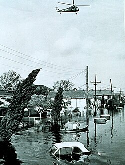
The Ninth Ward has faced repeated devastation from flooding. A levee break at Florida Avenue caused significant flooding during the 1915 New Orleans Hurricane, and the Lower 9th Ward suffered catastrophic losses during Hurricane Betsy in 1965.
Hurricane Katrina
In 2005, Hurricane Katrina brought unprecedented destruction. Storm surges caused multiple severe levee breaches along the MRGO and the Industrial Canal. The Lower 9th Ward was hit most violently; currents were so strong they displaced buildings from their foundations and propelled a barge (ING 4727) directly into the neighborhood.
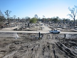
The Upper 9th Ward also suffered from levee failures near the Desire neighborhood, though the high ground of Bywater largely escaped significant flooding. Eastern New Orleans faced flooding from multiple sources, including breaches in the MRGO and overtopping of the lake level to the north.
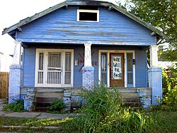
Recovery and Modern Era
The resurgence of the Ninth Ward has been uneven. New Orleans East has seen the growth of a vibrant Vietnamese commercial and dining hub, despite setbacks from the 2010 Deepwater Horizon oil spill. The Michoud Assembly Facility remains a critical economic driver, currently fabricating the core stage of NASA's Space Launch System.
Infrastructure improvements continue, with the resurfacing of major arteries like St. Claude Avenue and Poland Avenue, although many residential streets still require repair.
| Section | Key Neighborhoods | Defining Characteristics | Major Water Boundary |
|---|---|---|---|
| Lower 9th Ward | Holy Cross | High Black homeownership; severe Katrina damage | Industrial Canal / MRGO |
| Upper 9th Ward | Bywater, Desire, Florida | Riverfront charm mixed with industrial history | Industrial Canal |
| Eastern New Orleans | New Orleans East | Largest area; Vietnamese commercial hub | MRGO / Lake Pontchartrain |
Frequently Asked Questions
What is the difference between the 9th Ward and the 9th planning district?
They are different designations. The 9th Ward is a geographic and political boundary that actually encompasses land within planning districts 7, 8, 10, and 11.
Why was the Lower 9th Ward so severely affected by Hurricane Katrina?
The area suffered from two large breaches in the Industrial Canal flood protection system, which allowed violent storm surges to enter the neighborhood, destroying homes and displacing structures.
Who is Ruby Bridges and why is she associated with the 9th Ward?
Ruby Bridges was the first Black student to integrate William Frantz Elementary School in 1960, an event that sparked the New Orleans school desegregation crisis.
What is the significance of the Michoud Assembly Facility?
Located in the ward, it is a major source of employment and is currently the site where the core stage of NASA's Space Launch System is fabricated.
Which parts of the 9th Ward escaped the worst of the Katrina flooding?
The high ground of Bywater on the Mississippi River side of St. Claude Avenue, as well as certain parts of the Gentilly Ridge and lakefront fill, avoided the most significant flooding.