Tamanrasset: The Oasis Capital of the Ahaggar Mountains
Nestled deep within the southern reaches of Algeria, Tamanrasset serves as a vital oasis city and the capital of the Tamanrasset Province. Situated in the dramatic landscape of the Ahaggar Mountains, this city is the primary urban center for the Algerian Tuareg people. At an elevation of 1,320 meters (4,330 ft), it provides a unique high-altitude sanctuary amidst the vast, arid expanse of the Sahara.
Despite its challenging environment, Tamanrasset is a flourishing oasis. The city is known for its ability to produce a variety of crops, including citrus fruits, apricots, dates, almonds, cereals, corn, and figs. Today, it remains a critical hub for trade and a point of interest for tourists who visit during the cooler months to explore the Museum of the Hoggar, which showcases the rich life and culture of the Tuareg.
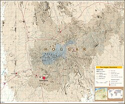
Key Facts
- Location: Ahaggar Mountains, Southern Algeria.
- Elevation: 1,320 meters (4,330 ft).
- Population: Estimated 140,955 by 2025.
- Climate: Hot desert climate (BWh).
- Primary Culture: Chief city of the Algerian Tuareg.
- Infrastructure: Served by Tamanrasset Airport and the Trans-Sahara Highway.
History and Evolution
The name Tamanrasset is believed to originate from "Imanrassaten," a noble tribe associated with the Ajjers who once used the wadi (dry riverbed) region to mark grazing boundaries. Historically, the city evolved as a central node in a vast network of camel caravan trade routes connecting major African hubs such as Kano, Lake Chad, Gao, Agades, and Zinder.
Colonial Era and Fort Laperrine
During the period of French rule, the city took on a military character. In 1905, the Catholic priest Charles de Foucauld established a hermitage here, followed by the construction of a fort by 1915. Foucauld was later killed outside his compound on December 1, 1916. The settlement was eventually named Fort Laperrine in honor of General François-Henry Laperrine, who died in the nearby desert in 1922.
Modern Events and Strategic Importance
The region has witnessed several significant events in recent decades. On May 1, 1962, an accidental venting occurred during a French underground nuclear test near Ecker, 150 km north of the city, releasing radioactive gases into the atmosphere. In March 2003, the city was the site of the Air Algérie Flight 6289 crash.
In 2010, Tamanrasset's strategic location led it to become the headquarters for the Joint Military Staff Committee. This four-country initiative involving Algeria, Mali, Niger, and Mauritania was established to coordinate military activities in the Pan-Sahel region to combat Al-Qaeda in the Islamic Maghreb.
Climate and Geography
Tamanrasset is classified under the BWh (hot desert climate) system. While it experiences very hot summers, the high elevation helps moderate the peak temperatures. Winters are generally mild, and rainfall is scarce throughout the year, with occasional precipitation occurring in late summer due to the northern extension of the Intertropical Convergence Zone (ITCZ).
| Metric | Winter (Jan) | Summer (Jul) | Annual Average |
|---|---|---|---|
| Mean Daily Max Temp | 20.5°C (68.9°F) | 35.3°C (95.5°F) | 22.4°C (72.3°F) Mean |
| Mean Daily Min Temp | 4.9°C (40.8°F) | 23.4°C (74.1°F) | 15.4°C (59.7°F) Mean |
| Average Precipitation | 1.3 mm (0.05 in) | 8.0 mm (0.31 in) | 58.4 mm (2.30 in) |
Demographics and Society
The city has seen steady growth, with the population rising from 72,741 in 1998 to an estimated 140,955 by 2025. Education levels vary, with a literacy rate of 69.8% (78.4% for males and 60.8% for females). Approximately 4.3% of the population has attained tertiary education, while 14.1% have completed secondary education.
The commune is composed of 14 localities, including Tamanrasset, Assekrem, and In Dalag. Culturally, the city is noted for its strict practice of Islam and traditional social structures, which contrast with the more Mediterranean regions of northern Algeria.
Frequently Asked Questions
What is the primary ethnic influence in Tamanrasset?
Tamanrasset is the chief city of the Algerian Tuareg, who were historically the town's main inhabitants.
What crops are grown in the Tamanrasset oasis?
Despite the desert climate, the oasis produces dates, citrus fruits, apricots, almonds, figs, corn, and cereals.
How is Tamanrasset connected to other regions?
The city is accessible via the Tamanrasset Airport and the Trans-Sahara Highway.
What is the significance of the Museum of the Hoggar?
The museum is a major tourist attraction that features exhibits depicting the traditional life and culture of the Tuareg people.
What is the climate like in Tamanrasset?
It has a hot desert climate (BWh) characterized by very hot summers, mild winters, and very little annual rainfall.