Southern Patagonian Ice Field Border Dispute
The Southern Patagonian Ice Field is a massive expanse of glaciers nestled within the Patagonian Andes. As the largest non-polar continental ice field accessible by land, it holds immense geographical and political significance. In Argentina, it is referred to as the continental ice, while Chile calls it the southern ice field to distinguish it from the northern ice field.
Despite its breathtaking beauty, the region has been the subject of a long-standing border dispute between Argentina and Chile. While initial boundaries were established over a century ago, specific sectors of the border remain pending definition as of 2026, governed by a complex history of treaties, expert commissions, and diplomatic agreements.
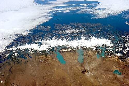
Key Facts
- Location: Patagonian Andes, spanning the border of Argentina and Chile.
- Status: The border in this sector remains partially undefined according to the 1998 agreement.
- Primary Conflict: Disagreement over whether the border follows the highest peaks or the continental watershed (divortium aquarum).
- Key Landmarks: Mount Fitz Roy and Mount Stokes serve as critical anchor points for the boundary.
- Governing Treaties: The Treaty of 1881 and the subsequent Agreement of 1998.
Historical Delimitation and the 1898 Landmarks
The foundation for the border was laid by the Treaty of 1881. To implement this treaty, both nations appointed experts—Diego Barros Arana for Chile and Octavio Pico Burgess for Argentina—to carry out the demarcation. A primary point of contention arose in 1892 when Barros Arana proposed that the limit be fixed at the continental divortium aquarum (the line that separates the drainage basins of different river systems), a thesis rejected by Argentina.
By October 1, 1898, a set of landmarks was agreed upon by experts including Francisco Moreno and Diego Barros Arana. These markers were intended to define the boundary through the rugged terrain.
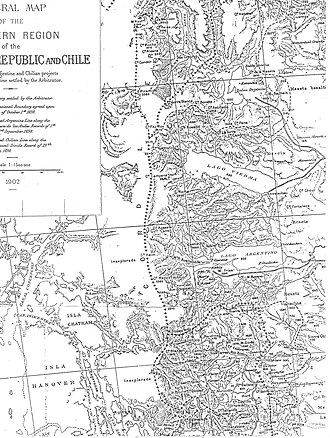
![Argentine map of 1912 showing historical boundary markers agreed upon by the Argentine and Chilean experts (Fitz Roy, Huemul, Campana, Agassiz, Heim, Mayo, and Stokes/Cervantes)[9][12][10][11]](/images/6e/85/6e8565e1f7585e41c05e410cd394395c77af5110bcb8d97d573079453b9f11a7.jpg)
| Landmark | Coordinates (DMS) | Coordinates (Decimal) |
|---|---|---|
| Fitz Roy | 49°16′17.02″ S, 73°02′36.80″ W | 49.271394°S 73.043556°W |
| Huemul | 49°25′21.59″ S, 73°02′08.57″ W | 49.4226639°S 73.0357139°W |
| Campana | 49°42′42.38″ S, 73°10′56.81″ W | 49.7117722°S 73.1824472°W |
| Agassiz | 49°57′34.19″ S, 73°27′16.71″ W | 49.9594972°S 73.4546417°W |
| Heim | 50°09′49.55″ S, 73°22′12.64″ W | 50.1637639°S 73.3701778°W |
| Mayo 2380 | 50°20′35.25″ S, 73°19′16.45″ W | 50.343125°S 73.3212361°W |
| Stokes (Cervantes) | 50°34′12.17″ S, 73°08′47.92″ W | 50.5700472°S 73.1466444°W |
![Boundary based on 1898 landmarks set by the peritos in the Southern Patagonian Ice Field.[20][9]](/images/93/c2/93c26d7747124c6295baae755a6c98783efc7a427dba9cf1004c8ae57b9f1097.png)
The Struggle for Demarcation
In 1941, the Joint Commission on Boundaries (COMIX) was established to reposition milestones based on the 1881 treaty and the 1893 protocol. However, as mapping technology evolved, the two countries diverged in their interpretations of the boundary line between Mount Fitz Roy and Mount Stokes.
The Chilean Perspective
Chile argued that the boundary should follow the intermediate summits identified in 1898. Using 1972 Military Geographic Institute charts, they proposed a line passing through the Adela range, Huemul, Campana, and other specific peaks, eventually reaching Mount Cervantes (identified as the Stokes of 1898).
The Argentine Perspective
Argentina contended that the demarcation should follow the highest peaks that divide the waters, utilizing more modern mapping techniques from the 1980s and 90s. Their proposed line included the Mariano Moreno range and the Malaspina range.
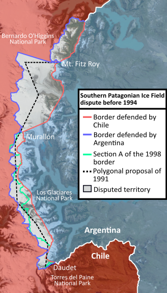
In 1991, Presidents Menem and Aylwin attempted to resolve the deadlock by proposing a polygonal line to divide the territory equitably. This proposal failed as neither national congress accepted it; Argentina feared the loss of 1,057 square kilometers of Los Glaciares National Park, while Chile feared losing 1,238 square kilometers of Bernardo O'Higgins National Park.
The 1998 Agreement and Current Status
On December 16, 1998, a new agreement was signed to replace the failed polygonal line. This agreement returned to the principles of the 1881 treaty—prioritizing high peaks and the continental watershed—while incorporating straight lines in specific sectors. Crucially, it ensured Chile maintained access to Mount Fitz Roy and Argentina maintained access to Mount Stokes.
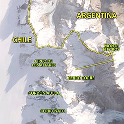
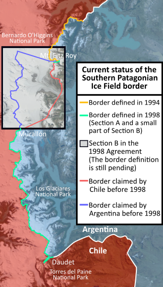
The agreement divided the area into sections. Section B, for example, runs from the summit of Fitz Roy to Cerro Murallón, utilizing a combination of watershed lines and straight-line coordinates. However, a rectangular territory between Fitz Roy and Mount Murallón remained without a final demarcation, requiring the Joint Boundary Commission to create a detailed 1:50,000 scale chart.
![The area of Laguna Escondida is a point where the boundary would be in such a way that Argentina is approximately eight kilometers (5.0 mi) from the Pacific Ocean.[24]](/images/77/cd/77cdb060518c089288e8b9ed54cf39d0ca72bd23ec0304f6f03a711aaa9bbc69.jpg)
Pending Definitions and Modern Friction
Despite the 1998 agreement, full demarcation has not been achieved. In 2006, Argentina called for Chile to comply with the agreement to finalize the boundary. Tensions resurfaced in 2021 when Chilean President Sebastián Piñera authorized a chart (SHOA N° 8) that omitted the non-defined zone rectangle, instead using cartography from before 1998. This has led to discrepancies where both nations claim approximately a thousand square kilometers more ice than the other.
Frequently Asked Questions
What is the primary cause of the Southern Patagonian Ice Field dispute?
The dispute stems from differing interpretations of the 1881 treaty, specifically whether the border should follow the highest mountain peaks or the continental watershed (the line dividing water drainage basins).
What was the "polygonal line" and why did it fail?
The polygonal line was a 1991 proposal by the presidents of Argentina and Chile to divide the territory equitably. It was rejected by both countries' congresses due to concerns over the loss of land within their respective national parks.
How did the 1998 agreement attempt to solve the issue?
The 1998 agreement replaced the polygonal line with a route based on the 1881 treaty's principles of high peaks and watersheds, while using straight lines in certain areas and guaranteeing mutual access to key peaks like Fitz Roy and Stokes.
Why is the border still considered "pending" today?
While the 1998 agreement provided a framework, the actual physical demarcation and the creation of agreed-upon detailed charts for certain sectors (such as the area between Fitz Roy and Mount Murallón) have not been completed.
What is the significance of the SHOA N° 8 chart?
The SHOA N° 8 chart, authorized by the Chilean government in 2021, is controversial because it removed the rectangle indicating the non-defined zone, leading to accusations from Argentina that Chile is unilaterally claiming disputed territory.