Perito Moreno Glacier: The Dynamic Ice Giant of Patagonia
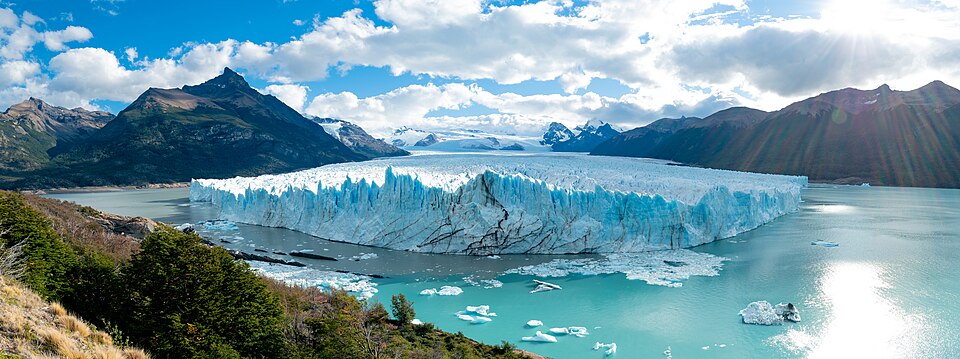
Deep in the heart of Southern Patagonia lies one of the world's most awe-inspiring natural wonders: the Perito Moreno Glacier. Located within Los Glaciares National Park in the Santa Cruz Province of Argentina, this massive ice formation is a centerpiece of the region's rugged beauty and a primary draw for international travelers.
The glacier is one of 48 fed by the Southern Patagonian Ice Field, a vast system shared with Chile and the world's third-largest reserve of fresh water. Spanning 30 kilometers in length and 5 kilometers in width, the glacier is a testament to the raw power of nature, characterized by its towering ice walls and dramatic movements.
Key Facts
- Location: Los Glaciares National Park, Argentina (originating in Chile).
- Dimensions: 30 km long, 5 km wide, and 170 m thick.
- Fresh Water Source: Southern Patagonian Ice Field.
- Primary Phenomenon: Periodic ice-dam ruptures at Lago Argentino.
- Current Status: Retreating on the northern front since 2020.
Geography and Physical Characteristics
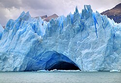
The Perito Moreno Glacier is a massive ice formation covering approximately 250 square kilometers. Its terminus—the end of the glacier—meets the waters of Lago Argentino, where the ice rises an average of 74 meters above the water's surface. While the surface height is impressive, the total depth of the ice reaches 170 meters.
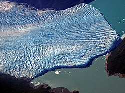
Historically, the glacier was noted for its unusual stability. For much of the late 20th and early 21st centuries, it maintained a state of equilibrium, meaning it accumulated mass at roughly the same rate it lost it. However, since 2020, glaciologists have observed the northern front retreating, a change potentially linked to global climate change.
A History of Names and Borders
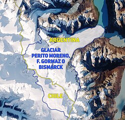
The glacier's identity has evolved alongside the geopolitical boundaries of South America. It was first sighted by non-indigenous explorers in 1879 by Juan Tomás Rogers of the British Chilean Navy, who named it Francisco Gormaz. Later, Rudolph Hauthal of the Argentine Boundary Commission renamed it Bismarck in honor of the Prussian Chancellor.
The name we use today was established in 1899 by Lieutenant Iglesias of the Argentine Hydrographic Institute, who named it after Francisco Moreno, a 19th-century pioneer and explorer. While the glacier's terminus is in Argentina, a 1998 agreement clarified that a small portion of its origin remains within Chile.
The Spectacular Rupture Cycle
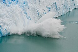
The most famous characteristic of Perito Moreno is its natural cycle of damming and rupture. As the glacier advances, its weight pushes ice across the inner fjord of Lago Argentino, eventually reaching the Península de Magallanes. This creates a natural ice dam that bisects the lake, separating the Brazo Rico (Rico Arm) from the Canal de los Témpanos (Iceberg Channel).
Because the water in the Brazo Rico has no outlet, it can rise up to 30 meters above the level of the main lake. Eventually, the immense pressure of the dammed water forces a breach in the ice, resulting in a spectacular rupture that sends a massive torrent of water crashing back into the main body of Lago Argentino.
Types of Rupture Events
Glaciologists classify these discharge events into three distinct categories based on how the water is released:
- Sudden Discharge: Rapid collapses with high flow rates. For example, the 2008 event peaked at 8,000 m³ per second.
- Progressive Discharge: Slower releases often involving the formation of subglacial tunnels. The 2013 event took 85 days to complete.
- Minor Discharge: Occurs when the ice does not completely block the passage, resulting in low-level water elevation and slow release.
Tourism and Wildlife
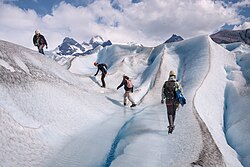
The glacier is a global tourism hub, with the nearby city of El Calafate serving as the primary gateway. Visitors can explore the glacier via a network of walkways at the visitor center or take boat tours to view the northern flank. For the more adventurous, trekking tours using crampons (metal spikes attached to boots for traction on ice) allow visitors to walk directly on the glacier surface.
Beyond the ice, the glacier hosts a remarkable resident: the Andiperla willinki. Also known as the "Patagonian dragon," this small glacier stonefly (approximately 1.5 cm long) spends its entire life on the ice, feeding on wind-borne bacteria. Once thought to be extinct, it was rediscovered in 2001.
| Feature | Detail |
|---|---|
| Total Area | 250 km² (97 sq mi) |
| Length | 30 km (19 mi) |
| Width at Terminus | 5 km (3.1 mi) |
| Maximum Ice Thickness | 170 m (558 ft) |
| Average Height above Water | 74 m (240 ft) |
| Primary Water Body | Lago Argentino |
Frequently Asked Questions
How often does the Perito Moreno Glacier rupture?
There is no fixed frequency for the ruptures. While they were traditionally estimated to occur every three to four years, they have happened more frequently in some periods and not at all for several years in others.
Is the glacier growing or shrinking?
For a long time, the glacier was in a state of equilibrium. However, since 2020, it has been retreating on its northern front, which scientists suggest may be due to climate change.
What is the "Patagonian Dragon"?
The Patagonian dragon is the Andiperla willinki, a rare species of glacier stonefly that lives its entire life cycle on the ice, feeding on bacteria carried by the wind.
Can tourists walk on the glacier?
Yes, tour companies offer guided trekking experiences, including "mini-trekking" (about 1.5 hours) and "big ice" (about 5 hours) tours, providing crampons for safety.
Why does the water level rise in the Brazo Rico?
The water level rises because the glacier advances to the coast of the Península de Magallanes, creating an ice dam that blocks the flow of water from the Brazo Rico into the main body of Lago Argentino.