Rose Park: A History of Community and Environmental Recovery
Rose Park stands as a testament to the evolving landscape of Salt Lake City, transitioning from a post-war residential dream to a modern neighborhood defined by its resilience and greenery. Developed during a pivotal era of American growth, the area has navigated complex social beginnings and significant environmental challenges to become a sought-after community for today's families.
The Post-War Origins of Rose Park
Established in the 1940s and 1950s, Rose Park was envisioned by developer Alan E. Brockbank as an affordable subdivision. Designed specifically to provide quality housing for veterans returning from World War II, the neighborhood offered larger plots than older Salt Lake City areas, such as The Avenues. The primary goal was to create accessible, durable brick homes for working-class families.
However, the development reflected the systemic prejudices of the era. The subdivision's declaration included a racial covenant, a restrictive agreement that prohibited anyone other than White or Caucasian individuals from occupying the lots, with the sole exception of domestic workers of other races employed by the owners.
Following the war, the neighborhood experienced a surge in growth as vacant lots were filled. While many early residents were non-Mormon blue-collar workers, their employment differed from nearby Murray; rather than working in smelters, Rose Park residents were largely employed by major railroad companies, including Union Pacific, Southern Pacific, and the Los Angeles-Salt Lake Railroad.
Modern Evolution and Architecture
Today, the demographic of Rose Park has diversified. While its roots are in the railroad industry, current residents include a wide array of professionals, such as engineers, architects, police officers, real estate brokers, and business managers. Young families are increasingly moving into the area, renovating the original homes.
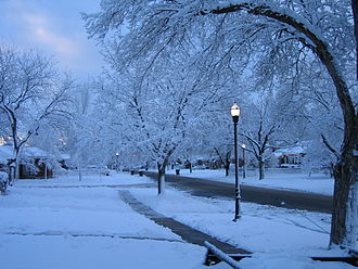
The architecture remains characteristic of its origin, with most homes constructed of brick and averaging between 1,600 and 1,800 square feet, though some early stick-framed houses still exist. One of the neighborhood's most defining features is its canopy of large, densely spaced trees—including various fruit trees—planted by the original WWII-era families. This natural heritage faced a significant trial on September 8, 2020, when a windstorm with category three hurricane-force winds toppled many of the area's oldest trees, resulting in power outages and property damage.
The Rose Park Sludge Pit Superfund Site
Beyond its residential charm, Rose Park has dealt with a serious industrial legacy. In the early 1980s, a hazardous site was identified near Rosewood Park and east of the Rose Park Golf Course. This site was the result of local refineries dumping waste products into a pit from 1930 until 1957.
The waste consisted of acidic sludge containing sulfur dioxide and polycyclic aromatic hydrocarbons (carcinogenic compounds). Because Rose Park relies on scattered wells for municipal water, there was significant concern regarding groundwater contamination. Although no contaminants were ever detected in the water supply, the potential risk prompted the state of Utah to petition the U.S. Environmental Protection Agency (EPA).
Remediation and Recovery
In 1982, the EPA officially designated the area as the "Rose Park Sludge Pit" on the Superfund list—a federal program designed to clean up the nation's most contaminated land. The Amoco oil company, identified as a potentially liable party, agreed to fund and execute the cleanup in 1985.
The remediation strategy involved two primary engineering solutions:
- Slurry Wall: A barrier constructed around and under the pit to prevent sludge from migrating into the groundwater.
- Clay Cap: A thick layer of clay placed over the pit, which was then topped with grass to seal the site.
Since these measures were implemented, the site has passed all five-year reviews. The EPA has deemed the solution protective of both human health and the environment, with no new threats identified.
Key Facts
- Developer: Alan E. Brockbank created the area for returning WWII veterans.
- Housing: Typical homes are brick, averaging 1,600 to 1,800 square feet.
- Industry: Early residents were primarily employed by Union Pacific, Southern Pacific, and Los Angeles-Salt Lake Railroads.
- Environmental Issue: The Rose Park Sludge Pit contained carcinogenic hydrocarbons and sulfur dioxide.
- Cleanup: Amoco oil company installed a slurry wall and clay cap starting in 1985.
- Current Status: The Superfund site is considered protective of human health and the environment.
| Category | Details |
|---|---|
| Development Era | 1940s and 1950s |
| Original Target Market | Returning WWII GIs |
| Primary Home Material | Brick |
| Superfund Designation | 1982 (Rose Park Sludge Pit) |
| Contaminants | Polycyclic aromatic hydrocarbons and sulfur dioxide |
| Remediation Method | Slurry wall and clay cap |
Frequently Asked Questions
Who originally developed Rose Park?
The neighborhood was developed by Alan E. Brockbank in the 1940s and 50s to provide affordable brick housing for veterans returning from World War II.
What was the nature of the racial covenants in Rose Park?
The original subdivision declaration prohibited any person of a race or nationality other than White or Caucasian from occupying the lots, except for domestic employees of a different race.
What caused the environmental contamination in the area?
Local refineries dumped acidic sludge containing sulfur dioxide and carcinogenic polycyclic aromatic hydrocarbons into a pit from 1930 to 1957.
How was the Rose Park Sludge Pit cleaned up?
The Amoco oil company constructed a slurry wall around and under the pit to protect groundwater and installed a clay cap topped with grass over the surface.
Is the groundwater in Rose Park currently safe?
Yes. While the threat of contamination prompted the cleanup, no contaminants were ever detected in the municipal wells, and the site has passed all subsequent five-year EPA reviews.
What happened to the neighborhood's trees in 2020?
On September 8, 2020, a windstorm with category three hurricane-force winds toppled many of the neighborhood's oldest and largest trees, causing power outages and property damage.