Rhine Province: The Industrial Heart of Prussian Power
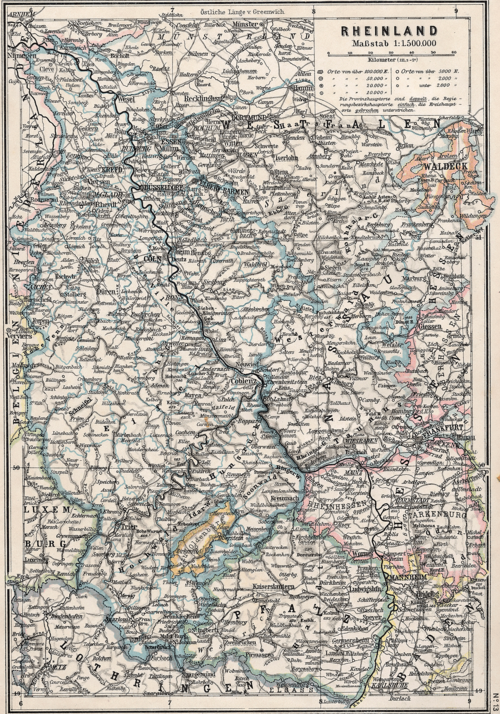
The Rhine Province (German: Rheinprovinz), often referred to as Rhenish Prussia, served as the westernmost territory of the Kingdom of Prussia and later the Free State of Prussia from 1822 to 1946. Established by merging the provinces of the Lower Rhine and Jülich-Cleves-Berg, it became a cornerstone of the German Reich's economic and strategic strength.
With its capital in Koblenz and its provincial assembly in Düsseldorf, the region was characterized by its dense population, diverse religious landscape, and immense industrial capacity. By 1939, the province had grown to support approximately 8 million inhabitants, making it the most populous region of Prussia.
Key Facts
- Existence: 1822 to 1946.
- Capital: Koblenz.
- Peak Population: Approximately 7.9 million (1939).
- Economic Status: The most important manufacturing district in Germany.
- Modern Successors: Primarily North Rhine-Westphalia and Rhineland-Palatinate.
Geography and Administration
The Rhine Province was strategically positioned, bordering the Netherlands to the north, Luxembourg and Belgium to the west, and Lorraine to the south. Its eastern boundaries were shared with the Prussian provinces of Westphalia and Hesse-Nassau, as well as the Grand Duchy of Hesse-Darmstadt. A notable geographical feature was the Rhine river, which flowed through the province, providing a vital waterway for trade and transport.
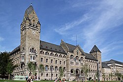
Administratively, the province was divided into five Regierungsbezirke (administrative districts): Aachen, Cologne, Düsseldorf, Koblenz, and Trier. Due to its frontier location, the region was heavily fortified, with major strongholds at Wesel, Koblenz (Ehrenbreitstein), and Cologne (with Deutz).
Demographics and Society
The population was predominantly ethnically German, though cultural influences varied by region. In 1905, the population of over 6.4 million was split between Roman Catholics (roughly 4.47 million) and Protestants (1.87 million), with a smaller Jewish community of about 55,000. The left bank of the Rhine was largely Catholic, while the right bank was more evenly split.
The region was the most densely populated area of Prussia, averaging 617 persons per square kilometer. Unlike other Prussian provinces, the Rhine Province was heavily urbanized; more than half of its population worked in commerce and industry, while less than a quarter relied on agriculture.
Economic Powerhouse
Known as the "richest jewel in the crown of Prussia," the province combined natural mineral wealth with a prime location for transit. This synergy transformed it into Germany's leading manufacturing hub.
Agriculture and Natural Resources
While the southern plateaus were limited to oats and potatoes, the northern lowlands and river valleys were highly fertile. The region was famous for its vine-culture, particularly in the Mosel and Rhine valleys. Additionally, the province produced commercial crops such as tobacco, hops, flax, and beetroot for sugar production.
Industrial Specialization
The province hosted a diverse array of industries:
- Textiles: Cloth in Aachen, silk in Krefeld, and cotton-weaving in the Wupper valley.
- Manufacturing: Leather in Malmedy and glass in the Saar district.
- Chemicals: Dyes produced in Elberfeld-Barmen.
- Beverages: Large-scale beer production and sparkling Mosel wine for export to Britain.
Political Turmoil and World Wars
The 20th century brought significant instability to the region. Following World War I, the Treaty of Versailles mandated the Allied occupation of the Rhineland to create a buffer zone between Germany and its western neighbors.
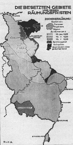
The occupation was marked by tension, including the separation of the Saar region (administered by the League of Nations until 1935) and the annexation of the East Cantons (Eupen, Malmedy, and Sankt Vith) by Belgium. Although Allied troops left early in 1930, the region remained demilitarized.
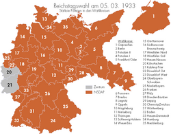
The rise of the Nazi Party saw a unique political landscape in the Rhine Province. In the March 1933 federal election, the districts of Cologne-Aachen and Koblenz-Trier were the only areas in all of Germany where the Nazi Party failed to win a plurality of votes.
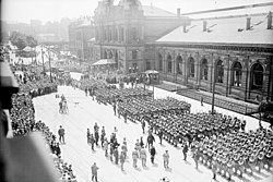
In 1936, Nazi Germany violated international treaties by remilitarizing the Rhineland. This move was widely supported by the local population, driven by a surge in nationalism and resentment toward previous Allied occupations.
The Final Campaigns (1944–1945)
During the closing stages of World War II, the Rhineland was the site of brutal fighting. Key operations included the failed Operation Market Garden and the costly battle for the Hürtgen Forest, where the U.S. Army suffered 24,000 casualties. By March 1945, Allied forces successfully crossed the Rhine through operations such as Operation Varsity and the capture of the Remagen bridge, effectively ending German control of the region.
The Dissolution of the Province
After Germany's unconditional surrender in 1945, the province was split between British and French occupation zones. In August 1946, the Rhine Province was officially abolished. Its northern territories merged with Westphalia to form North Rhine-Westphalia, while the southern portions helped form Rhineland-Palatinate. The Saarland was initially a separate protectorate before joining the Federal Republic of Germany in 1957.
| Feature | Details |
|---|---|
| Period of Existence | 1822–1946 |
| Administrative Capital | Koblenz |
| Major Cities | Cologne, Düsseldorf, Aachen, Trier |
| Primary Industries | Mining, Textiles, Steel, Viticulture |
| 1939 Population | ~7.93 Million |
| Modern States | North Rhine-Westphalia, Rhineland-Palatinate, Saarland, Hesse |
Frequently Asked Questions
What was the Rhine Province?
It was the westernmost province of the Kingdom of Prussia and later the Free State of Prussia, existing from 1822 to 1946. It served as a vital industrial and strategic hub for the German Reich.
Why was the Rhine Province considered the "richest jewel" of Prussia?
This title was due to its immense mineral wealth, fertile river valleys for agriculture and wine, and its position as the most important manufacturing district in Germany.
How did the Treaty of Versailles affect the region?
The treaty mandated the demilitarization of the Rhineland and its occupation by Allied forces to act as a buffer zone. It also led to the loss of the Saar region and the annexation of certain cantons by Belgium.
What happened to the province after World War II?
The province was abolished in 1946. Its territories were divided between the British and French occupation zones, eventually forming the modern German states of North Rhine-Westphalia and Rhineland-Palatinate, with parts also going to Saarland and Hesse.
Which cities were most important in the Rhine Province?
While Koblenz was the official capital, Cologne was the largest and most economically significant city. Other major administrative and industrial centers included Düsseldorf, Aachen, and Trier.