Province of Hohenzollern: The Prussian Enclave in Swabia
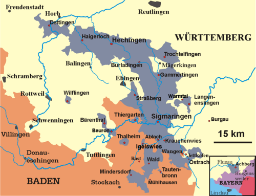
The Province of Hohenzollern (known in German as Hohenzollernsche Lande) was a unique administrative district of Prussia that existed from 1850 to 1946. Located in Swabia, a region in southern Germany, it served as the ancestral homeland of the House of Hohenzollern—the noble dynasty that provided the kings of Prussia and later the emperors of the German Empire.
Unlike typical Prussian provinces, the Hohenzollern Lands were formed from the merger of two smaller principalities. While technically classified as a Regierungsbezirk (a governmental district, which was usually a subdivision of a larger province), it possessed nearly all the legal rights and status of a full Prussian province.
Key Facts
- Existence: 1850 to 1946.
- Capital: Sigmaringen.
- Total Area (1939): 1,142 km² (441 sq mi).
- Peak Population (1939): 73,844.
- Current Location: Now part of the state of Baden-Württemberg.
- Origins: Formed from the principalities of Hohenzollern-Hechingen and Hohenzollern-Sigmaringen.
The Formation of the Hohenzollern Lands
The roots of the province lie in the Catholic branch of the House of Hohenzollern. The principalities of Hohenzollern-Hechingen and Hohenzollern-Sigmaringen had maintained hereditary treaties with Prussia since 1695 and 1707, respectively. However, the political instability of the German Revolutions of 1848–1849 accelerated their integration into the Prussian state.
King Frederick William IV of Prussia was initially hesitant to annex the territories. His advisor, Rudolf von Stillfried-Rattonitz, convinced the King that failing to act would force the Swabian princes to align with the House of Württemberg, a long-standing hereditary rival of Prussia. To avoid this, the King approved a treaty of annexation signed on December 7, 1849. The princes abdicated that same day, and Prussia took formal possession of Sigmaringen on April 6, 1850, and Hechingen on April 8, 1850.
Administrative Structure and Governance
Because of its small size and population—approximately 65,500 people at its inception—the Hohenzollern Lands were the smallest of all Prussian provinces. While the district president held a rank equal to the Oberpräsidenten (governors) of larger provinces and was represented in the Prussian State Council (Staatsrat), the region remained subordinate to ministries in Berlin.
Due to its geographical isolation from the Prussian heartland, many administrative functions were delegated to the nearby Rhine Province. This included the medical and higher education systems. Legal jurisdiction also shifted over time; until 1879, the court of appeal was located in Arnsberg, 450 km to the north, before moving to the Higher Regional Court in Frankfurt am Main.
Local Government and Districts
In 1875, Prussia introduced Provinzialverbänden (provincial associations) to enhance local self-government. The Hohenzollern Lands established a Landeskommunalverband, a public law corporate body managed by an elected district parliament (Kommunallandtag). This system of self-administration persisted until 1973.
The region was initially divided into seven Oberämter (upper bureaus):
- Gammertingen
- Haigerloch
- Hechingen
- Ostrach
- Sigmaringen
- Trochtelfingen
- Wald
By 1925, these were consolidated into two primary districts: Hechingen and Sigmaringen.
Conflict and Political Transition
The province's strategic location often made it a target during regional conflicts. During the Austro-Prussian War of 1866, troops from Württemberg—allies of Austria—occupied the Hohenzollern Lands from June 27 to August 6.
Following World War I in 1918, the region became part of the Free State of Prussia during the Weimar Republic. However, the 1933 Nazi seizure of power effectively suspended provincial autonomy. The area was placed under the direct rule of the Gau (territory) of Württemberg-Hohenzollern, led by Gauleiter Wilhelm Murr, though it formally remained a Prussian district.
Post-War Era and Integration
After World War II, the Hohenzollern Lands fell within the French occupation zone. In 1946, the military government merged the region with the southern portion of the former state of Württemberg to create the state of Württemberg-Hohenzollern, with its capital in Tübingen. This entity later became part of West Germany in 1949.
In 1952, Württemberg-Hohenzollern was absorbed into the larger state of Baden-Württemberg. The distinct boundaries of the Hohenzollern Lands finally disappeared during the district reform of 1973. Today, the territory is split among nine rural districts (Landkreise), with the majority residing in the Sigmaringen and Zollernalbkreis districts.
Population Growth
| Year | Population |
|---|---|
| 1852 | 65,634 |
| 1880 | 67,624 |
| 1900 | 66,780 |
| 1925 | 71,840 |
| 1939 | 73,706 |
Frequently Asked Questions
Why was the Province of Hohenzollern created?
It was created in 1850 after the annexation of the principalities of Hohenzollern-Hechingen and Hohenzollern-Sigmaringen. King Frederick William IV of Prussia annexed them to prevent the territories from falling under the influence of the House of Württemberg, a hereditary rival.
Was it a full province of Prussia?
Technically, it was a Regierungsbezirk (governmental district), which is usually a subdivision of a province. However, it was granted almost all the rights and status of a full Prussian province, including representation in the Prussian State Council.
Which city served as the capital?
The town of Sigmaringen served as the administrative headquarters and capital of the Hohenzollern Lands.
What happened to the province after World War II?
In 1946, the French military government merged the region with southern Württemberg to form the state of Württemberg-Hohenzollern. In 1952, this state was absorbed into the modern state of Baden-Württemberg.
How did the province handle its administration?
While subordinate to Berlin, the province relied heavily on the nearby Rhine Province for its medical, higher education, and certain administrative systems due to its geographical location in southern Germany.