Prussian Districts: The Administrative Foundation of Modern Germany
The administrative landscape of the former Kingdom of Prussia was defined by a sophisticated hierarchy of governance known as Kreise (literally 'circles'). These districts functioned similarly to modern counties or shires, providing a vital link between the central state and local municipalities. Established as part of a broader effort to modernize the state, these units became the blueprint for the administrative districts used in Germany today.
The Origins of the Kreis System
The Prussian districts were established between 1815 and 1818 during the Stein-Hardenberg Reforms. These reforms aimed to create a highly effective public administration structure. The districts were positioned as an intermediate level of governance, sitting between the high-level provinces and the Regierungsbezirke (government districts), and the lower-level Gemeinden (municipal governments).
Following the Napoleonic Wars and the 1815 Congress of Vienna, Prussian lands were reorganized into ten provinces. Notably, East Prussia, West Prussia, and the Grand Duchy of Posen were located beyond the borders of the German Confederation.
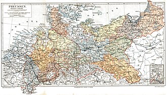
Administrative Structure and Governance
Each province was internally divided into up to six Regierungsbezirke, which were further subdivided into local districts. These districts were managed by an administrator known as a Landrat. To simplify identification, districts typically adopted the name of their capital, the Kreisstadt, which served as the seat of the administrative office, or Landratsamt.
The physical size of a district was designed for practical accessibility. A typical district had a diameter of approximately 20 to 40 miles (32 to 64 km). This specific scale ensured that officials could reach even the most remote villages by carriage within a single day, although the districts themselves were rarely perfect circles in shape.
Urban vs. Rural Districts
As the Industrial Revolution sparked rapid urbanization from the 1830s onward, the administration evolved to distinguish between city and country governance:
- Stadtkreise (Urban Districts): Larger cities often maintained self-administration based on traditional German town law, forming exempt urban districts comparable to independent cities.
- Landkreise (Rural Districts): These comprised the smaller towns and villages surrounding the urban centers.
In many cases, a city served as the administrative seat for the surrounding rural area, leading to paired designations, such as the Stadtkreis and Landkreis of Königsberg.
Key Facts
- Established: 1815–1818 via the Stein-Hardenberg Reforms.
- Hierarchy: Provinces → Regierungsbezirke → Kreise → Gemeinden.
- Leadership: Each district was headed by a Landrat.
- Design: Sized (20–40 miles diameter) for one-day carriage travel to remote areas.
- Legacy: Served as the model for present-day German districts.
- Territorial Change: The districts of Eupen and Malmedy were annexed by Belgium in 1925.
| Level | Unit Name | Key Characteristic |
|---|---|---|
| Highest | Province | Ten primary regional divisions |
| Intermediate High | Regierungsbezirk | Up to six per province |
| Intermediate Low | Kreis (District) | Led by a Landrat; based on the Kreisstadt |
| Lowest | Gemeinde | Local municipal government |
Frequently Asked Questions
What was the purpose of the Stein-Hardenberg Reforms?
These reforms, occurring between 1815 and 1818, were designed to create a modern and highly effective public administration structure, which included the establishment of the districts (Kreise).
What is the difference between a Stadtkreis and a Landkreis?
A Stadtkreis was an exempt urban district for larger cities with self-administration, while a Landkreis was a rural district consisting of smaller towns and villages.
Who was the Landrat?
The Landrat was the administrator who headed the local district (Kreis) and operated out of the Landratsamt.
Why were the districts sized between 20 and 40 miles in diameter?
This size was chosen to ensure that the most remote villages within the district could be reached by carriage within one day.
What happened to the districts of Eupen and Malmedy?
Following World War I, these two districts were annexed by Belgium in 1925, resulting in a German-speaking minority within Belgium.