Port of South Louisiana: A Global Hub for U.S. Grain Exports
The Port of South Louisiana (French: Port de la Louisiane du Sud) stands as a cornerstone of international trade and a vital artery for the United States economy. Stretching 54 miles (87 km) along the Mississippi River between New Orleans and Baton Rouge, the port is headquartered in LaPlace, Louisiana. It serves as a primary gateway for agricultural products moving from the American Midwest to the rest of the world.
The port's strategic location allows it to handle a massive volume of cargo, making it one of the most significant maritime hubs globally. Its role is particularly critical for the agricultural sector, as it manages approximately 60% of all raw grain exports from the United States.
Key Facts
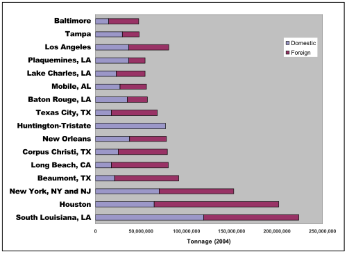
- Global Ranking: Ranks third in the world for total trade by tonnage.
- Grain Dominance: Handles roughly 60% of all U.S. raw grain exports.
- Geographic Reach: Extends 54 miles along the Mississippi River.
- Regional Synergy: Works alongside the ports of New Orleans and Baton Rouge to manage 55% to 70% of U.S. corn, soy, and wheat exports.
- Navigational Depth: Drafts range from 12 feet to 48 feet (3.6 to 14.6 m).
Geography and Infrastructure
The maritime complex comprising the ports of New Orleans, South Louisiana, and Baton Rouge covers a combined 172 miles (277 km) on both banks of the Mississippi River. This vast network utilizes a variety of channels and side canals to facilitate the movement of massive vessels.
A key feature of the region's infrastructure was the Mississippi River-Gulf Outlet Canal, which extended 67 miles (108 km) from New Orleans to the Gulf of Mexico; however, this channel is now closed by a rock dike at Bayou La Loutre. For active shipping, the channel from New Orleans to Baton Rouge maintains a draft—the vertical distance between the waterline and the bottom of the hull—of 48 feet (14.6 m).
Maintaining these depths is critical for safety and efficiency. Following the devastation of Hurricane Katrina, the National Oceanic and Atmospheric Administration (NOAA) Office of Coast Survey deployed sonar and scanners to assess underwater damage. These detailed surveys provided the essential data port authorities needed to determine when it was safe to reopen the ports for commercial traffic.
Economic Impact and Trade Volume
The collective influence of the South Louisiana, New Orleans, and Baton Rouge ports is immense. When measured by total trade tonnage, these three ports rank 3rd, 4th, and 15th globally, respectively. In terms of total dollar value, they rank 12th (New Orleans), 16th (South Louisiana), and 27th (Baton Rouge) among all world ports.
The logistics chain relies heavily on barges, which transport grains from the Mississippi River to these ports for storage and eventual export. According to the North American Export Grain Association, as of August 2005, these facilities serve as the gateway for 55% to 70% of all U.S. exported wheat, soy, and corn.
While exports dominate the narrative, these ports are also vital for imports. The region regularly receives essential global commodities, including steel, rubber, coffee, fruits, and vegetables. To illustrate the scale of activity, the Port of New Orleans alone sees approximately 6,000 vessels annually.
| Port Name | Global Rank (Tonnage) | Global Rank (Dollar Value) | Primary Role |
|---|---|---|---|
| Port of South Louisiana | 3rd | 16th | Raw Grain Exports |
| Port of New Orleans | 4th | 12th | General Trade & Logistics |
| Port of Baton Rouge | 15th | 27th | Regional Trade |
Frequently Asked Questions
How much of the U.S. grain export does the Port of South Louisiana handle?
The Port of South Louisiana handles approximately 60% of all raw grain exports from the United States.
What is the navigational depth of the channel between New Orleans and Baton Rouge?
The channel runs at a 48-foot (14.6 m) draft, though overall navigational depths across the river, channels, and side canals range from 12 to 48 feet.
What types of goods are imported through these Louisiana ports?
Common imports include rubber, steel, coffee, vegetables, and fruits.
What happened to the Mississippi River-Gulf Outlet Canal?
The canal, which once extended 67 miles to the Gulf of Mexico, has been closed by a rock dike built across the channel at Bayou La Loutre.
How did NOAA assist the ports after Hurricane Katrina?
The NOAA Office of Coast Survey used sonar and scanners to assess underwater damage, allowing port authorities to make informed decisions about reopening the ports.