Lower Mississippi River
The Lower Mississippi River serves as the critical southern artery of the Mississippi River System. Beginning at Cairo, Illinois—where the Ohio River and the Middle Mississippi River converge—this stretch of water flows approximately 1,000 miles (1,600 km) southward before emptying into the Gulf of Mexico. As the most heavily traveled segment of the entire system, it is a cornerstone of American commerce and transport.
Unlike the upper reaches of the river, the Lower Mississippi is characterized by a lack of locks and dams. Instead, its flow is managed through a complex network of man-made structures designed to protect land and ensure the river remains a viable highway for global trade.
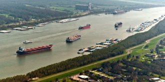
Key Facts
- Length: Approximately 1,600 km (990 mi).
- Source: Cairo, Illinois (elevation 315 ft / 96 m).
- Mouth: Gulf of Mexico.
- Navigation Depth: 9 feet from St. Louis to Baton Rouge; 45 feet from Baton Rouge to the Gulf.
- Primary Infrastructure: Levees, dikes, and spillways (no locks or dams).
Infrastructure and Water Management
To control flooding and maintain a reliable navigation channel for barges, the river is constrained by levees (raised banks) and dikes. In the lower reaches, particularly near New Orleans, several specialized structures are used to manipulate water flow, including the Old River Control Structure, the Bonnet Carré Spillway, and the Mississippi River–Gulf Outlet Canal.
![Levees on the Lower Mississippi River.[6]](/images/a2/e4/a2e4735f58ea6a179ef40e263ff4919c7e5cbe79d6ed0f2e08cd29e9d444e695.gif)
Environmental Impact and History
Throughout the 20th century, engineering efforts focused on separating the river from its natural floodplain. While this protected urban and agricultural areas, it came with significant ecological costs. The combination of channelization and the loss of bottomland forests to agriculture has led to a decrease in fish and wildlife habitats and a decline in overall water quality.
Agricultural runoff has introduced pesticides and caused eutrophication—a process where excess nutrients trigger algae blooms that deplete oxygen. This has contributed to increased turbidity (cloudiness of the water), siltation, and the expansion of the hypoxic zone (an area of very low oxygen) in the Gulf of Mexico, which is toxic to many aquatic organisms.
Commercial Navigation and Shipping
The US Army Corps of Engineers maintains a channel depth of 9 feet from St. Louis, Missouri, to Baton Rouge, Louisiana. From Baton Rouge to the Gulf, the depth increases to 45 feet, which allows large container ships and cruise ships to access the Port of New Orleans.
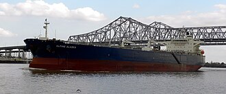
Bulk cargo ships with an air draft (the distance from the waterline to the highest point of the ship) of less than 150 feet can pass under the Huey P. Long Bridge to reach Baton Rouge. To further increase capacity, a feasibility study has been conducted to dredge this section to 50 feet, which would accommodate New Panamax ship depths.
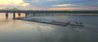
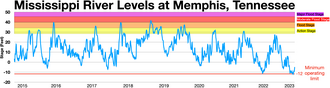
Despite its engineering, the river remains susceptible to nature. In late 2022, critically low water levels caused significant backups, stalling over 100 tow boats and 2,000 barge units, which led to a sharp increase in barge rates.
![Downbound barge rates In late 2022, low water levels in the Lower Mississippi River caused two backups that held up over 100 tow boats with 2,000 barge units, causing barge rates to soar[9][10]](/images/65/d3/65d32af6703cba7009a8149daac3776d3b573e7d72e9c9f966e88a0a9bea6d5b.png)
Lower Mississippi River Summary
| Feature | Detail |
|---|---|
| Starting Point | Cairo, Illinois |
| Ending Point | Gulf of Mexico |
| Total Length | ~1,600 km (990 mi) |
| Max Navigation Depth | 45 feet (Baton Rouge to Gulf) |
| Key Management Tools | Levees, Dikes, Spillways |
Frequently Asked Questions
Are there any locks or dams on the Lower Mississippi River?
No, unlike the upper portions of the river, the Lower Mississippi has no locks or dams. It relies on levees and dikes to manage water flow and navigation.
What is the maximum ship size that can reach Baton Rouge?
Bulk cargo ships can reach Baton Rouge provided they have an air draft of less than 150 feet to fit under the Huey P. Long Bridge.
How does agricultural runoff affect the Gulf of Mexico?
Runoff leads to eutrophication and oxygen depletion, which expands the hypoxic zone in the Gulf of Mexico, making the water toxic to various aquatic organisms.
Who is responsible for maintaining the river's channel depth?
The US Army Corps of Engineers is responsible for maintaining the channel depths, including the 9-foot depth from St. Louis to Baton Rouge.
What happened to barge traffic in late 2022?
Low water levels caused two major backups involving over 100 tow boats and 2,000 barge units, resulting in a surge in barge rates.