New Orleans Metropolitan Area
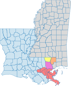
The New Orleans metropolitan area, officially designated as the New Orleans–Metairie metropolitan statistical area (MSA), is a vital urban hub centered on the city of New Orleans. Often referred to as Greater New Orleans, this region encompasses seven Louisiana parishes—the administrative equivalent of counties in other U.S. states. As the most populous metropolitan area in Louisiana and the 59th most populous in the United States, it serves as a critical cultural and economic engine for the Gulf Coast.
The region is part of a larger network known as the New Orleans–Metairie–Slidell combined statistical area (CSA), which extends its reach into Mississippi and includes additional metropolitan and micropolitan areas.
Key Facts
- 2020 Population: 1,007,275 (MSA)
- 2025 Population: 1,354,257 (CSA)
- GDP: $102.437 billion (2023)
- Total Area: 3,755.2 square miles
- Highest Point: 371 feet
- Lowest Point: -6.6 feet
- Major Economic Drivers: Tourism, shipping (Port of New Orleans), and energy.
Geography and Urban Structure
The geography of Greater New Orleans is defined by its relationship with water, ranging from the Mississippi River to the Gulf of Mexico. The region's elevation varies significantly, with some areas sitting below sea level, necessitating complex flood control systems.
Principal Communities
New Orleans serves as the principal city of the MSA. It is supported by several satellite cities with populations exceeding 50,000, including Kenner and the unincorporated community of Metairie. Numerous other communities, such as Gretna, Hammond, and LaPlace, provide essential residential and commercial support to the urban core.
Infrastructure and Flood Control
Due to its low-lying terrain, the region relies on critical infrastructure to manage water levels. A primary example is the Bonnet Carré Spillway, managed by the Mississippi Valley Division of the U.S. Army Corps of Engineers, which is used to divert floodwaters from the Mississippi River.

Demographics and Population Trends
The population of the New Orleans metropolitan area has seen significant fluctuations over the decades. While the region grew steadily from 1950 through 2000, it faced a severe setback in 2005.
The Impact of Hurricane Katrina
On August 29, 2005, Hurricane Katrina—a Category 3 storm at landfall—devastated the region. Structural failures in the levee and flood wall systems led to catastrophic flooding in New Orleans. This resulted in a steep population decline; for instance, the city's population dropped from an estimated 453,728 just before the storm to 389,476 by 2020. While the city has regained a portion of its loss, the overall metropolitan population remains lower than its 2000 peak of 1,337,726.
Regional Composition
As of the 2010 census, the racial composition of the MSA was 58.2% White (52.4% non-Hispanic white), 32.5% Black or African American, 3.5% Asian, and 8.6% Hispanic or Latino. The region also maintains a diverse housing market, with a median owner-occupied home value of $211,900 in 2019, which was approximately 25% higher than the Louisiana state average.
Economy and Regional Influence
Greater New Orleans is the largest regional economy in Louisiana, bordering the economically significant Greater Baton Rouge area. The region is a powerhouse for tourism, with visitors spending over $10.05 billion in 2019 alone.
Major Industries and Employers
The economy is diversified across several sectors:
- Corporate Headquarters: Entergy, a Fortune 500 company, is headquartered here.
- Major Operators: Globalstar, AT&T, GE Capital, and the Port of New Orleans are among the largest entities in the area.
- Transportation: The Louis Armstrong New Orleans International Airport is a major hub with 15 airlines and 54 nonstop flights.

The Port of New Orleans continues to be a cornerstone of the economy, benefiting from over $296 million in capital infrastructure investments to improve container turnaround and capacity.
Education and Labor
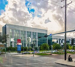
The region supports a robust workforce of over 650,000 civilians. Education is a key pillar, with more than 65,000 students enrolled across nine universities and eight community or technical colleges.
Regional Summary Table
| Metric | New Orleans-Metairie MSA | New Orleans-Metairie-Slidell CSA |
|---|---|---|
| Population (Recent) | 1,007,275 (2020) | 1,354,257 (2025) |
| Primary State(s) | Louisiana | Louisiana & Mississippi |
| GDP (2023) | $102.437 Billion | N/A |
| Key Components | 7 Parishes | MSAs & μSAs (including Picayune) |
Frequently Asked Questions
What is the difference between the MSA and the CSA in New Orleans?
The Metropolitan Statistical Area (MSA) is a smaller, core urban area centered on New Orleans and Metairie encompassing seven parishes. The Combined Statistical Area (CSA) is a broader region that includes the MSA plus other adjacent metropolitan and micropolitan areas, such as Slidell and Picayune, extending into Mississippi.
How did Hurricane Katrina affect the population of the region?
Hurricane Katrina caused a significant population decline due to levee failures and flooding. The city of New Orleans saw its population drop from approximately 453,728 in 2005 to an estimated 389,476 by 2020, which negatively impacted the total numbers for the entire metropolitan area.
What are the primary economic drivers of Greater New Orleans?
The economy is driven by tourism, which generated over $10 billion in 2019, the shipping and logistics operations of the Port of New Orleans, and major corporate presence from companies like Entergy, AT&T, and GE Capital.
Which parishes are included in the New Orleans-Metairie MSA?
The MSA currently encompasses seven Louisiana parishes, including Orleans, Jefferson, St. Bernard, St. Tammany (historically), St. Charles, St. John the Baptist, and St. James. Note that St. Tammany was split into its own metropolitan area in 2023.