Pontchartrain Expressway
The Pontchartrain Expressway is a critical six-lane transportation artery in New Orleans, Louisiana. Spanning 7.0 miles (11.3 km), this expressway serves as a parallel section of Interstate 10 (I-10) and U.S. Route 90 Business (US 90 Bus.), providing essential connectivity between the city's Central Business District (CBD) and the surrounding regions. Its name is derived from Pontchartrain Boulevard, which it replaced in several areas, and ultimately from Lake Pontchartrain, the body of water that defines the northern border of New Orleans.
Key Facts
- Total Length: 7.0 miles (11.3 km).
- Primary Designations: I-10 and US 90 Business (also temporarily designated as I-910).
- Key Connection: Leads directly to the Crescent City Connection bridge.
- Lowest Point: Dips to 12 feet (3.7 m) below sea level near the Metairie Cemetery.
- Timeline: Planned in 1946, construction began in 1955, and the final section opened in 1962.
Route and Infrastructure
The expressway begins at the I-610 Split near the Orleans–Jefferson parish line. From there, it follows I-10 into the heart of the New Orleans CBD, passing by the Superdome. At a major stack interchange with U.S. 90 (Claiborne Avenue), the route splits: I-10 continues northeast, while the expressway follows US 90 Bus. southeast as an elevated highway leading to the Crescent City Connection.
Historically, a portion of the route follows the right-of-way of the former New Basin Canal, which was filled between 1937 and 1947. To accommodate the Norfolk Southern Railway overpass near Metairie Cemetery, the expressway descends to 12 feet below sea level. Because this low-lying area was prone to flooding during heavy storms, a depth meter was once painted on the support columns to warn motorists. To mitigate this, a new pumping station was completed in 2004 to ensure the route remains open during emergency evacuations.
Evolution and Modernization
The expressway has undergone several phases of expansion to handle increasing traffic volumes. In the mid-1980s, the US 90 Bus. section was expanded to support the second span of the Crescent City Connection, which opened in 1988. Further reconstruction in the early 1990s introduced two reversible HOV (High Occupancy Vehicle) lanes, stretching from the intersection of Earhart Boulevard and Magnolia Street across the bridge to the Westbank Expressway.
Safety improvements were also a priority in the late 1990s. This included the construction of new ramps connecting West I-10 to West Business U.S. 90 and westbound Claiborne Avenue, replacing older, more hazardous configurations. Additionally, a direct ramp from 90B East to I-10 East was completed by 1989.
Impact of Hurricane Katrina
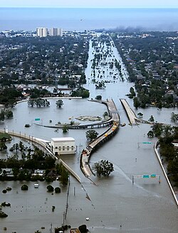
The vulnerability of the expressway's low-lying sections was highlighted during Hurricane Katrina. The 2004 pumping station was overwhelmed, leading to extensive flooding of the railroad underpass and the I-610/West End Boulevard interchange. This was exacerbated by the 17th Street Canal breach, located approximately one mile north.
The resulting floods isolated Orleans Parish from most western access points, leaving the Crescent City Connection as one of the few viable routes into the east bank. While the elevated sections in the CBD remained largely undamaged, some trapped evacuees used the expressway and the bridge to travel on foot toward dry ground on the west bank.
Future Designations: I-49 and I-910
Currently, the US 90 Bus. portion of the expressway carries a temporary, unsigned designation as Interstate 910. This designation covers all freeway portions of US 90 Bus., including the Pontchartrain Expressway, the Crescent City Connection, and the Westbank Expressway. Once Interstate 49 is completed from Lafayette to New Orleans, this section will be officially re-signed as I-49.
| Feature | Details |
|---|---|
| Length | 7.0 miles (11.3 km) |
| Major Junctions | I-10, I-610, US 90, US 90 Bus. |
| Key Landmarks | Superdome, Crescent City Connection, Metairie Cemetery |
| Construction Period | 1955–1962 |
| Future Status | To be re-signed as I-49 |
Frequently Asked Questions
What is the relationship between the Pontchartrain Expressway and I-10?
The Pontchartrain Expressway serves as a parallel section of I-10 and US 90 Business. It begins where I-10 enters Orleans Parish and follows I-10 into the Central Business District before splitting off toward the Crescent City Connection.
Why does the expressway dip below sea level?
The expressway dips to 12 feet below sea level near the Metairie Cemetery to allow the Norfolk Southern Railway line to pass overhead via an overpass.
What is Interstate 910?
Interstate 910 is a temporary, unsigned designation for the freeway portions of US 90 Business. It is a placeholder until the completion of Interstate 49 in the region.
How did Hurricane Katrina affect the expressway?
The railroad underpass and the I-610/West End Boulevard interchange were extensively flooded after the local pumping station was overwhelmed and the 17th Street Canal breached.
What are the HOV lanes on the expressway?
The High Occupancy Vehicle (HOV) lanes are two reversible lanes that run from the intersection of Earhart Boulevard and Magnolia Street across the Crescent City Connection to the Westbank Expressway.