Interstate 10: The Southernmost Transcontinental Highway
Interstate 10 (I-10) stands as the southernmost transcontinental artery of the United States Interstate Highway System. Spanning a massive 2,460.34 miles (3,959.53 km), it is the fourth-longest Interstate in the nation, trailing only I-90, I-80, and I-40. From the Pacific coast of California to the Atlantic coast of Florida, I-10 serves as a critical corridor for commerce, travel, and regional connectivity.
Originally conceptualized in the 1956 Interstate Highway network plan, the route was developed over several decades. The final segment of the cross-country journey was completed in 1990 with the opening of the Deck Park Tunnel in Phoenix, Arizona.
Key Facts
- Total Length: 2,460.34 miles (3,959.53 km).
- Route Span: From Santa Monica, California, to Jacksonville, Florida.
- States Traversed: California, Arizona, New Mexico, Texas, Louisiana, Mississippi, Alabama, and Florida.
- Highest Point: Just east of Tucson, Arizona, where westbound lanes exceed 5,000 feet (1,500 m) above sea level.
- Longest State Segment: Texas, which accounts for approximately 36% of the entire route.
Route Breakdown by State
California
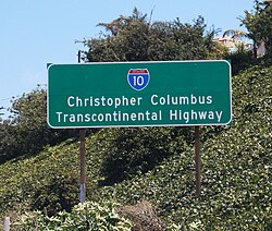
The highway begins at its west terminus in Santa Monica. In the Los Angeles area, it is known as the Santa Monica Freeway, with a specific segment designated as the Rosa Parks Freeway. Further east, the route becomes the San Bernardino Freeway. Historically, a sign in Santa Monica designated the route as the Christopher Columbus Transcontinental Highway from 1976 until its removal in 2022.
Arizona
In Arizona, I-10 is designated as the Pearl Harbor Memorial Highway. It plays a vital role in the Phoenix metropolitan area as the Papago Freeway and the Maricopa Freeway. The route reaches its highest elevation east of Tucson, near the milemarker 320 rest stop.
New Mexico
Following much of the old US Route 80 path, I-10 passes through Lordsburg, Deming, and Las Cruces. A significant portion of the route between exit 24 and exit 135 runs concurrently with US 70.
Texas
Texas hosts the longest segment of I-10. The highway features unique infrastructure, such as the "Texas U-turn" underpasses in El Paso. In Houston, the Katy Freeway expansion project created one of the largest freeway reconstructions in U.S. history, widening the road to as many as 26 lanes, including managed toll and frontage lanes.
Louisiana
Louisiana's section is characterized by challenging geography. The Atchafalaya Swamp Freeway utilizes the Atchafalaya Basin Bridge to cross wetlands, and the Horace Wilkinson Bridge carries traffic over the Mississippi River in Baton Rouge. In New Orleans, the Pontchartrain Expressway is a key segment, though some low-lying areas are highly susceptible to flooding during hurricanes.
Mississippi, Alabama, and Florida
After passing through Mississippi and Alabama, I-10 enters Florida, where it again carries the Pearl Harbor Memorial Highway designation. It travels north of Pensacola and Tallahassee, eventually reaching its eastern terminus at the I-95 interchange in Jacksonville.
Infrastructure and Modernization
Since its completion in 1990, I-10 has undergone continuous expansion to handle increasing traffic volumes. Notable projects include:
- Broadway Curve Improvement Project (Phoenix): Completed in 2025, this 11-mile reconstruction expanded the highway to eight lanes to support a projected 25% traffic increase by 2040.
- Florida Widening: Capacity was increased to six lanes through Pensacola (2008) and Tallahassee (2009) to improve hurricane evacuation.
- Tucson Reconstruction: Major bridge and lane expansions were completed in 2009.
| Feature | Detail |
|---|---|
| West Terminus | SR 1, Santa Monica, CA |
| East Terminus | I-95 / US 17, Jacksonville, FL |
| Total Distance | 2,460.34 miles |
| Major Junctions | I-5, I-17, I-25, I-20, I-35, I-45, I-55, I-65, I-75, I-95 |
| Completion Date | 1990 |
Frequently Asked Questions
Which state has the longest section of I-10?
Texas contains the longest segment of any signed Interstate within a single state, accounting for approximately 36% of I-10's total length.
What is the highest point on I-10?
The highest elevation occurs just east of Tucson, Arizona, 20 miles west of Willcox, where westbound lanes briefly exceed 5,000 feet above sea level.
What is the Katy Freeway?
The Katy Freeway is a segment of I-10 in Houston, Texas, famous for being one of the widest freeways in the world, reaching up to 26 lanes including express and frontage lanes.
When was the entire length of I-10 completed?
The final section of the transcontinental route was completed in 1990 with the opening of the Deck Park Tunnel in Phoenix, Arizona.
Why was the Christopher Columbus sign removed in California?
The California state legislature authorized the removal of the "Christopher Columbus Transcontinental Highway" sign in 2022 following years of lobbying by Native Americans.