No Man's Land: From Medieval Disputes to Modern Kill Zones
No man's land refers to an uninhabited, desolate, or wasted area of land that remains unowned or unoccupied. Typically, these regions are under dispute between two or more parties who avoid entering the territory due to fear, legal uncertainty, or the threat of violence. While most commonly associated with the harrowing trench warfare of the early 20th century, the term has a long history spanning legal disputes, nautical terminology, and modern geopolitical conflicts.
Beyond its literal meaning, the phrase is frequently used as a metaphor to describe an ambiguous or indefinite situation, a jurisdictional gap, or an anomalous state of being where no clear rules apply.
Key Facts
- Ancient Origins: The term appears as early as the Domesday Book (1086) to describe land outside London's city walls.
- WWI Significance: It defined the lethal space between opposing trench systems, often riddled with barbed wire and land mines.
- Environmental Legacy: Some WWI sites, like the zone rouge in France, remain too toxic for human habitation today.
- Cold War Barriers: Examples include the Iron Curtain's uninhabited tracts and the mine-heavy "Cactus Curtain" at Guantánamo Bay.
- Modern Evolution: In the Russo-Ukrainian War, the "Gray Zone" has evolved into a "kill zone" due to constant drone surveillance.
The Origins and Evolution of the Term
Long before it became a military staple, "no man's land" described territorial and legal voids. According to Alasdair Pinkerton of Royal Holloway, University of London, the term was used in the 1086 Domesday Book for parcels of land just outside London's walls. By 1320, the Oxford English Dictionary notes the spelling nonesmanneslond, referring to territories involved in legal disagreements. In some cases, these areas served as dumping grounds for refuse or sites for public executions.
The term also found a home in nautical language, describing the space amidships between the forecastle (the sailors' living quarters) and the masts on square-rigged vessels, used for storing tackle and ropes. In the United Kingdom, it denoted extra-parochial spaces that existed beyond the jurisdiction of the church or royal fiefdoms.
No Man's Land in World War I
Although soldier and historian Ernest Swinton used the term in a 1908 short story, the British Army did not widely adopt it until later in World War I. Initially, soldiers simply referred to the area as "between the trenches." The term gained widespread popularity following the Anglo-German Christmas truce of 1914, eventually appearing in official communiqués and newspaper reports.
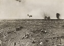
In practice, these zones varied in width from several hundred yards to as little as 10 metres (33 ft). They were characterized by a lethal combination of machine guns, mortars, and artillery fire. The terrain was often a nightmare of exploded shell craters, barbed wire, and rudimentary land mines, littered with the remains of soldiers who failed to cross the gap.
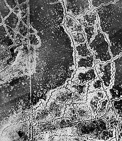
Crossing this space was a necessity for advancing troops, retreating soldiers, and the stretcher-bearers tasked with recovering the wounded. This static form of warfare persisted until the introduction of mechanized weapons, such as tanks and airplanes, which allowed armies to break through entrenched lines.
The scars of this era remain. In France, the zone rouge (red zone) near Verdun is still sealed off. Contaminated by arsenic, chlorine, and phosgene gas, the area is considered too dangerous for civilians. To contain the toxicity, the French government planted a forest of black pines, which Pinkerton describes as a "living sarcophagus," similar to the concrete structure used at Chernobyl.
Cold War and Geopolitical Buffer Zones
During the Cold War, no man's lands served as physical manifestations of ideological divides. Along the Iron Curtain, wide tracts of uninhabited land—filled with watchtowers and minefields—separated the Eastern Bloc from the West. These zones were deadly for escapees; for example, Peter Fechter was shot while attempting to cross the Berlin Wall.
A similar phenomenon occurred at the U.S. Naval Base at Guantánamo Bay. To prevent migrants from fleeing Cuba, the Cuban Army planted a 13-kilometre barrier of Opuntia cactus, known as the "Cactus Curtain." This area became the largest minefield in the Americas, with approximately 55,000 mines placed by both U.S. and Cuban forces. While the U.S. replaced its mines with sensors in 1996, the Cuban minefields remain.
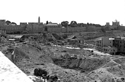
Israel and Jordan (1949–1967)
Following the 1949 Armistice Agreements, several regions between Israel and Jordan were designated as no man's land. These included areas in Jerusalem, specifically between the Walls of Jerusalem and Musrara, as well as strips of land north and south of Latrun. These zones were effectively eliminated during the Six-Day War.
The Modern Era: The Russo-Ukrainian War
Trench warfare returned to prominence during the War in Donbas (2014–2015) and again following the 2022 Russian invasion of Ukraine. The resulting landscapes—pockmarked by shells and mud—have been compared by observers, including retired U.S. Marine Corps Colonel Andrew Milburn, to the battlefields of Passchendaele and the ruins of Dresden.
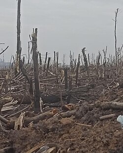
In this conflict, the no man's land is often called the Gray Zone. However, the proliferation of reconnaissance and attack drones has fundamentally changed this space. Constant aerial surveillance has turned the Gray Zone into a "kill zone," where any movement across open ground is immediately detected and targeted. This has forced soldiers to rely on extreme camouflage and underground shelters, as exposure for even a few seconds can be fatal.
Summary of Notable No Man's Lands
| Location/Conflict | Common Term | Defining Characteristics | Status/Outcome |
|---|---|---|---|
| World War I (Western Front) | No Man's Land | Barbed wire, craters, chemical gas | Ended by mechanized warfare |
| Iron Curtain | Border Zone | Watchtowers, minefields | Dissolved after Cold War |
| Guantánamo Bay | Cactus Curtain | Opuntia cactus, heavy minefields | U.S. mines replaced by sensors |
| Israel-Jordan (1949-67) | No Man's Land | Jurisdictional void in Jerusalem/Latrun | Eliminated in Six-Day War |
| Ukraine (Modern) | Gray Zone / Kill Zone | Drone surveillance, deep bunkers | Active conflict |
| Cyprus (since 1974) | The Green Line | UN Buffer Zone, abandoned Varosha | Active buffer zone |
Frequently Asked Questions
Where did the term "no man's land" originate?
The term is mentioned as early as 1086 in the Domesday Book to describe land outside London's city walls. It was later used in the 14th century to describe territories involved in legal disputes or as sites for executions.
How wide was no man's land during World War I?
The width varied significantly depending on the location, ranging from several hundred yards to as narrow as 10 metres (33 ft) in some sectors.
What is the "zone rouge" in France?
The zone rouge (red zone) is a region near Verdun that remains sealed off due to extreme contamination from arsenic, chlorine, and phosgene gas, as well as unexploded ordnance from World War I.
How have drones changed the nature of no man's land in Ukraine?
Drones have transformed the "Gray Zone" into a "kill zone." Constant surveillance makes open movement nearly impossible, erasing the protection once provided by trenches and forcing soldiers to rely on underground shelters and rapid, covered movement.
What was the "Cactus Curtain"?
The Cactus Curtain was a 13-kilometre barrier of Opuntia cactus planted by the Cuban Army in 1961 to prevent migrants from fleeing Cuba to the U.S. Naval Base at Guantánamo Bay.