New Zealand: A Pacific Island Nation
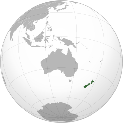
Located in the western South Pacific Ocean, New Zealand is a stunning island nation known for its dramatic landscapes and unique cultural heritage. The country consists of two primary landmasses—the North Island and the South Island—along with several smaller islands, including the Chatham Islands and Stewart Island (also known as Rakiura).
The indigenous Māori people originally referred to the North Island as Aotearoa, which translates to "The Land of the Long White Cloud." Today, Aotearoa serves as the Māori name for the entire country.
Geography and Natural Environment
New Zealand is situated approximately 2,000 km (1,200 mi) southeast of Australia, separated by the Tasman Sea. Its closest northern neighbors include Tonga, Fiji, and New Caledonia. Due to its extreme remoteness, New Zealand was among the last places on Earth to be settled by humans.
This long period of isolation allowed the region to develop a distinct biodiversity—a wide variety of plant, fungal, and animal life found nowhere else. The landscape is characterized by varied topography, featuring sharp mountain peaks like the Southern Alps. These geological features are the result of volcanic eruptions and tectonic uplift, where the Earth's crust is pushed upward by subterranean forces.
Demographics and Urban Centers
The population of New Zealand is primarily of European descent. The indigenous Māori people constitute the largest minority group, while Pasifika peoples (non-Māori) and Asians represent other significant minority populations, particularly within urban areas.
The country's administrative and economic hubs are centered in two major cities: Wellington, which serves as the capital, and Auckland, the most populous city in the nation.
Government and Political Structure
New Zealand is a constitutional monarchy. Charles III is the king and head of state, represented locally by a non-partisan governor-general. However, actual political power is vested in the democratically elected New Zealand Parliament, led by the prime minister, who serves as the head of government.
The Realm of New Zealand extends beyond the main islands to include several other territories:
- Cook Islands and Niue: Self-governing states in free association with New Zealand.
- Tokelau: A dependent territory.
- Ross Dependency: New Zealand's territorial claim in Antarctica.
Key Facts
- Māori Name: Aotearoa ("The Land of the Long White Cloud").
- Major Islands: North Island and South Island.
- Capital: Wellington.
- Largest City: Auckland.
- Head of State: King Charles III.
- Key Geographic Feature: The Southern Alps.
- Proximity: 2,000 km southeast of Australia.
| Category | Details |
|---|---|
| Primary Islands | North Island, South Island |
| Notable Smaller Islands | Stewart Island / Rakiura, Chatham Islands |
| Associated Territories | Cook Islands, Niue, Tokelau |
| Antarctic Claim | Ross Dependency |
Frequently Asked Questions
What does the name Aotearoa mean?
Aotearoa is the Māori name for New Zealand and is commonly translated into English as "The Land of the Long White Cloud."
Which city is the capital of New Zealand?
Wellington is the capital city, while Auckland is the most populous city.
How did New Zealand's unique biodiversity develop?
Because of its remoteness and long period of isolation from other landmasses, New Zealand developed a distinct variety of animal, plant, and fungal life.
Who holds the political power in New Zealand?
Political power is held by the democratically elected New Zealand Parliament under the leadership of the prime minister.
What are the Southern Alps?
The Southern Alps are sharp mountain peaks formed by volcanic eruptions and the tectonic uplift of land.