Zealandia: The Hidden Submerged Continent of Oceania
Hidden beneath the vast expanse of the Pacific Ocean lies a geological marvel known as Zealandia. Also referred to as Te Riu-a-Māui in Māori or Tasmantis, this massive stretch of continental crust is almost entirely submerged. Once a part of the ancient supercontinent Gondwana, Zealandia broke away between 83 and 79 million years ago, eventually sinking to become a "hidden" continent.
While it was once debated whether this landmass was a microcontinent or a continental fragment, modern geological evidence suggests it fulfills all the requirements of a true continent. With a total area of approximately 4,900,000 square kilometers, it is significantly larger than any known microcontinent, including Madagascar.
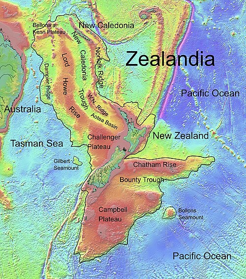
![Topography of Zealandia, outlined in pink. The linear ridges running north-northeast (Colville to the west and Kermadec to the east, separated by the Lau Basin) and southwest (the Resolution Ridge System) away from New Zealand are not considered part of Zealandia, nor are Australia (left), Vanuatu, or Fiji (top centre).[1]](/images/6d/2c/6d2c19cfa01cb7b19a2c8e8ba37a391052f9552cd5bbca156ac232015c5bb0c4.jpg)
Key Facts
- Total Area: Approximately 4,900,000 km², making it more than half the size of Australia.
- Submergence: About 94% of the landmass is currently underwater.
- Age: Recent studies suggest it is over one billion years old.
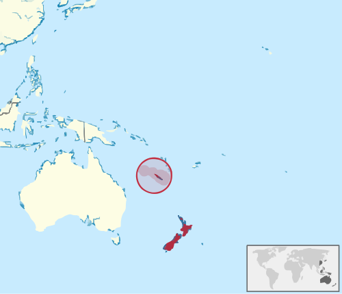
- Visible Land: New Zealand and New Caledonia are the primary areas remaining above sea level.
- Composition: Made of continental crust that is thinner (approx. 20 km) than typical continents.
The Geological Nature of Zealandia
Zealandia is characterized by two nearly parallel ridges separated by a failed rift—a point where the continental breakup stopped and became a filled graben (a depressed block of the Earth's crust). These ridges rise 1,000 to 1,500 meters above the ocean floor.
The reason Zealandia remains submerged, unlike other continents, is its crustal thickness. At roughly 20 km thick, its crust is thinner than average, meaning it does not float as high on the Earth's mantle. Geologists note that if sea levels were lower, Zealandia would have been recognized as a distinct continent long ago.
Tectonic Evolution and Movement
The history of Zealandia is one of constant motion. After separating from Australia via seafloor spreading in the Coral and Tasman seas, the landmass underwent significant shifts. Around 25 million years ago, the southern portion (on the Pacific Plate) began moving relative to the northern portion (on the Indo-Australian Plate), resulting in a displacement of about 500 km along the Alpine Fault.
By approximately 23 million years ago, the landmass may have been completely submerged. Its tectonic journey concluded with a final separation from Antarctica roughly 10 million years ago.
Volcanism and the Ring of Fire
Volcanic activity has been a recurring theme throughout Zealandia's history, occurring before, during, and after its split from Gondwana. Large-scale magmatism occurred during the Devonian period (370–368 million years ago) and the Early Cretaceous (129–105 million years ago). Interestingly, the magma composition in these regions is similar to that found in Antarctica and Australia, reflecting their shared origins.
Some scientists suggest that the geological evolution of Zealandia may have played a significant role in the formation of the Pacific Ocean's Ring of Fire, the zone of frequent earthquakes and volcanic eruptions.
Biogeography and Natural Resources
Despite its submergence, Zealandia's legacy lives on in its flora and fauna. New Zealand and New Caledonia serve as outposts for Antarctic flora, specifically podocarps and araucarias. Fossilized forests found at Curio Bay date back 180 million years to the Jurassic period, featuring trees related to the modern Norfolk pine and kauri.
Beyond biology, the region is rich in resources. It supports extensive inshore fisheries and contains significant gas fields, such as the Maui gas field near Taranaki. The seabed also holds mineral deposits, including ferromanganese nodules, volcanic massive sulfides, and ironsands.
Regional Summary and Demographics
Today, Zealandia is divided among several political jurisdictions, with New Zealand holding the vast majority of the exposed land.
| Region/Entity | Approx. Land Area (km²) | Percentage of Total Land | Key Feature |
|---|---|---|---|
| New Zealand | 267,988 | 93.49% | Largest exposed portion |
| New Caledonia | 18,576 | 6.48% | Northernmost outpost |
| Australian Territories | 96.25 | < 0.1% | Includes Norfolk Island |
As of 2024, the total human population residing on the exposed parts of Zealandia is approximately 5.4 million people. The city of Auckland is the largest urban center, housing about 1.7 million residents—roughly one-third of the continent's total population.
Frequently Asked Questions
Is Zealandia actually a continent?
Yes, a team of geologists concluded in 2017 that Zealandia fulfills all the requirements to be classified as a submerged continent based on its crustal thickness, density, and geological composition, rather than being a mere microcontinent or fragment.
How much of Zealandia is underwater?
Approximately 94% of the landmass remains submerged beneath the Pacific Ocean.
When did Zealandia separate from Gondwana?
Zealandia subsided and broke away from the supercontinent Gondwana between 83 and 79 million years ago.
What are the main landmasses that remain above sea level?
The largest parts of Zealandia above sea level are New Zealand and New Caledonia.
How old is the crust of Zealandia?
While previously thought to be younger, a 2021 study suggests that Zealandia is over one billion years old.