Neu-Ulm: A History of Resilience and Growth in Bavaria
Located in the heart of Swabia, Bavaria, Neu-Ulm is a town defined by its unique relationship with its neighbor, Ulm, and its strategic position along the Danube river. While it may appear as a modern urban center today, Neu-Ulm's identity was forged through shifting borders, military fortifications, and a remarkable post-war recovery.
The town serves as the administrative seat of the Neu-Ulm district, bridging the gap between Bavarian tradition and contemporary academic and economic development.
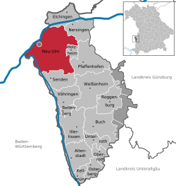
Key Facts
- State: Bavaria, Germany (Admin region: Schwaben).
- Population: 62,641 (as of December 31, 2024).
- Total Area: 80.99 km².
- Government: Led by Lord Mayor Katrin Albsteiger (CSU).
- Geography: Situated on the right bank of the Danube, with elevations ranging from 470 m to 527 m.
- Education: Home to the Neu-Ulm Fachhochschule (University of Applied Sciences).
The Evolution of Neu-Ulm
From a Riverbank Settlement to an Independent Town
The origins of modern Neu-Ulm date back to 1810, triggered by a change in sovereignty. When the city of Ulm transitioned from the Kingdom of Bavaria to the Kingdom of Württemberg, the Danube river became the official border between the two states. The land on the right bank remained under Bavarian control, establishing the foundation for Neu-Ulm as an independent entity.
Initially, the area was a modest collection of houses and taverns known as Ulm am rechten Donauufer (Ulm on the right-hand side of the Danube). The name "Neu-Ulm" first appeared in official records in 1814.
Military Expansion and the Federal Fort
The town experienced significant growth starting in 1841 with the construction of the Bundesfestung (Federal Fort of Ulm). Under the direction of Major Theodor von Hildebrandt and the wishes of King Ludwig I, Neu-Ulm was integrated into this massive fortification system. The arrival of a military garrison followed in 1853, facilitated by a new railway connection to Augsburg.
By the end of the 19th century, under Mayor Josef Kollmann, the town flourished. Key milestones included the 1897 tram line connecting Ulm and Neu-Ulm and the 1900 construction of the water tower, which remains a local landmark. By 1906, the town began expanding beyond its historic city walls to accommodate new factories.
War, Recovery, and the US Army Presence
The 20th century brought extreme volatility. While the town grew wealthy after World War I, World War II caused devastating damage. Allied bombing destroyed nearly 80% of the town and demolished all bridges crossing the Danube to Ulm.
The post-war era was characterized by the presence of the US Army, which remained stationed in Neu-Ulm until the 1990s. A significant site was the Wiley Barracks, which hosted the 1st Battalion, 81st Field Artillery Regiment. This unit managed nuclear capabilities, including Pershing 1, 1a, and II missiles, until the ratification of the Intermediate-Range Nuclear Forces Treaty in 1988. The battalion was eventually inactivated on June 30, 1991.
The departure of US forces created an economic vacuum and left numerous vacant military buildings, which the town eventually repurposed for civilian use.
Civic Identity and Administration
The Coat of Arms
Granted city status by King Ludwig II in 1869, Neu-Ulm's coat of arms (designed in 1857) is rich in symbolism. It features three horizontal bands of black, white, and blue with a central tower. The tower represents the Federal Fort, the black and white colors signify the link to Ulm, and the white and blue represent the town's association with Bavaria.
Governance and Districts
Neu-Ulm is divided into 14 districts, including Burlafingen, Finningen, and Wiley. Politically, the town is currently led by the Christian Social Union (CSU), with Katrin Albsteiger serving as Lord Mayor since March 2020.
Education and Science
The Neu-Ulm Fachhochschule (University of Applied Sciences) was established in 1994. Originally a branch of the Fachhochschule Kempten im Allgäu, it became independent in 1998. The university has evolved from occupying former US military barracks to moving into the Edison Center and eventually its own dedicated facility in 2008.
Town Overview Summary
| Category | Details |
|---|---|
| Coordinates | 48°23′N 10°00′E |
| Population (2024) | 62,641 |
| Area | 80.99 km² |
| Vehicle Registration | NU |
| Postal Codes | 89201–89233 |
| Time Zone | CET (UTC+1) / CEST (UTC+2) |
Notable Figures
Neu-Ulm has been home to or associated with various influential figures across different fields:
- Arts & Science: Botanist Otto Renner, sculptor Edwin Scharff, and composer Annette Thoma.
- Aviation: Flight pioneer Hermann Köhl.
- Public Life: Former German Finance Minister Theo Waigel and comedian Harald Schmidt.
- Sports: Footballers Orest Banach, Timo Wenzel, and Günay Güvenç, as well as Olympic silver medalist Edwin Jackson.
Frequently Asked Questions
Why is it called "Neu-Ulm"?
The name literally means "New Ulm." It was adopted after 1810 when the Danube river became the border between Bavaria and Württemberg, leaving the right bank as a separate Bavarian entity from the original city of Ulm.
What is the significance of the Bundesfestung?
The Bundesfestung (Federal Fort) was a massive fortification project started in 1841. It drove the town's early growth, bringing in soldiers, infrastructure, and the development of a military garrison.
What happened to the US Army bases in Neu-Ulm?
After the US Army departed in the early 1990s following the Intermediate-Range Nuclear Forces Treaty, many of the vacant buildings were repurposed, including the site of the Wiley Barracks which now houses the Neu-Ulm Fachhochschule.
What does the Neu-Ulm coat of arms represent?
The tower symbolizes the town's fortifications, while the colors black and white represent the connection to Ulm, and white and blue represent the state of Bavaria.