Mississippi Territory: The Foundation of Two Southern States
Before the modern borders of the American South were etched into the map, the Mississippi Territory served as a critical administrative bridge between colonial claims and statehood. Organized in 1798, this incorporated territory spanned a vast region that would eventually split to form the states of Mississippi and Alabama. Its history is a complex tapestry of diplomatic disputes, rapid population growth, and the challenging realities of frontier governance.
The territory's origins were rooted in a long-standing dispute between the United States and Spain. Following the Treaty of Madrid in 1795, Spain relinquished its claims to lands east of the Mississippi River, allowing the U.S. to organize the territory in 1798. Initially, the region extended from 31° N latitude to 32°28' North, covering roughly the southern half of what are now Alabama and Mississippi.
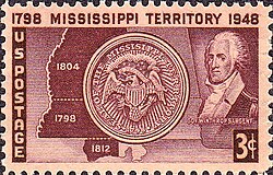
Key Facts
- Lifespan: 1798 to 1817.
- Capitals: Natchez (1798–1802) and Washington (1802–1817).
- Outcome: Divided into the State of Mississippi (1817) and the Alabama Territory (1817), the latter becoming a state in 1819.
- Population Growth: Increased from 8,850 in 1800 to 40,352 by 1810.
- Key Figures: Governors Winthrop Sargent, William C. C. Claiborne, and David Holmes.
Territorial Evolution and Borders
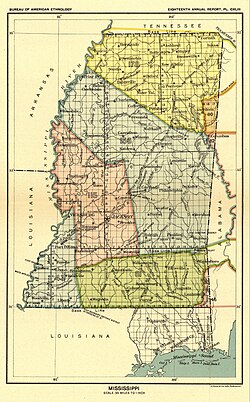
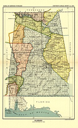
The geography of the Mississippi Territory was fluid, shaped by political scandals and diplomatic annexations. For years, the state of Georgia claimed nearly the entire area between 31° N and 35° N. However, following the Yazoo land scandal, Georgia surrendered these claims in 1802. By 1804, Congress expanded the Mississippi Territory to include this ceded land.
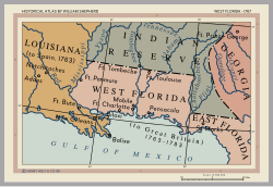
Further expansion occurred in 1812 with the annexation of the Mobile District. The borders remained a point of contention and negotiation, particularly regarding the Spanish boundary and indigenous lands.
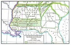
The Path to Statehood
By 1817, the territory had grown too large and populous for a single administration. Federal statutes enacted in March 1817 outlined a plan to divide the region. On December 10, 1817, the western half was admitted to the Union as the 20th state, Mississippi. The eastern half became the Alabama Territory, with St. Stephens on the Tombigbee River serving as its temporary seat of government. Alabama eventually achieved statehood on December 14, 1819.
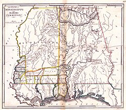
Settlement and Demographics
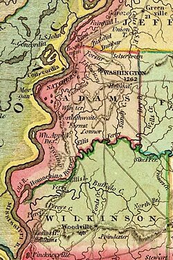
The territory experienced an explosive population boom during its first decade. Between 1800 and 1810, the population grew by 356%, driven by settlers moving into the fertile lands of the Deep South. This growth was concentrated in several key counties, with Adams County emerging as the most populous center.
| County | 1800 Population | 1810 Population |
|---|---|---|
| Adams | 4,660 | 10,002 |
| Wilkinson | — | 5,068 |
| Amite | — | 4,750 |
| Madison (Ala.) | — | 4,699 |
| Jefferson | 2,940 | 4,001 |
| Claiborne | — | 3,102 |
| Washington (Ala.) | 1,250 | 2,920 |
| Franklin | — | 2,016 |
| Baldwin (Ala.) | — | 1,427 |
| Wayne | — | 1,253 |
| Warren | — | 1,114 |
| Total | 8,850 | 40,352 |
Much of the land remained under the title of indigenous peoples, including the Choctaw, Chickasaw, Cherokee, and Creek, until various land cessions occurred.
Governance and Law
The territory was led by a series of appointed governors. Winthrop Sargent, the first governor, established the first court system, though his "Sargent's Code" was widely viewed by citizens as repressive. The early judiciary struggled with incompetence; for instance, judge Peter Bryan Bruin was noted for being frequently absent or intoxicated.
Governance improved under William C. C. Claiborne, who served from 1801 to 1803. Claiborne was known for his conciliatory approach toward Native Americans and his efforts to establish law and order, including the pursuit of the outlaw Samuel Mason. He also oversaw the first recorded mass vaccination in the territory during a 1802 smallpox epidemic.
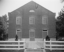
The final territorial governor, David Holmes (1809–1817), is remembered for his diplomacy and intelligence. He played a pivotal role in the peaceful occupation of parts of West Florida and presided over the constitutional convention of 1817.
Legislative Structure
The government featured a bicameral General Assembly consisting of a Legislative Council (upper house) and a House of Representatives (lower house). Initially, the Assembly elected the territorial delegate to the U.S. Congress, but this shifted to popular election in 1808.
Conflict and the War of 1812
The territory was not without violence, particularly during the War of 1812. A hostile faction of the Creeks, known as the Red Sticks, launched a devastating attack on Fort Mims on August 30, 1813. Due to poor scouting and tactical failures, the garrison was overwhelmed. Between 235 and 260 whites and friendly Indians were killed, while Creek losses were estimated at at least 100.
Frequently Asked Questions
What was the Mississippi Territory?
The Mississippi Territory was an organized incorporated territory of the United States that existed from 1798 to 1817, eventually splitting to form the states of Mississippi and Alabama.
Why was the capital moved from Natchez to Washington?
The territorial capital was moved on February 1, 1802, to Washington, located six miles up the Natchez Trace, to serve as the seat of government.
Who were the primary indigenous groups in the region?
The land was primarily titled to the Choctaw, Chickasaw, Cherokee, and Creek peoples before various land cessions were made to the United States.
What was the Yazoo land scandal?
The Yazoo land scandal was a controversy that led the state of Georgia to surrender its claims to vast areas of present-day Alabama and Mississippi in 1802, which were then added to the Mississippi Territory.
How did the territory handle the smallpox epidemic of 1802?
Under the leadership of Governor William C. C. Claiborne, the territory implemented the first recorded mass vaccination, which successfully saved Natchez from the disease.