Mississippi River Delta: Geology, Economy, and Coastal Preservation
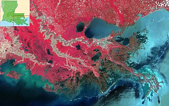
The Mississippi River Delta is a massive geographical feature where the Mississippi River meets the Gulf of Mexico in southeastern Louisiana. Spanning three million acres, this region stretches from Vermilion Bay in the west to the Chandeleur Islands in the east. As the seventh-largest river delta on Earth, it serves as a critical component of the Louisiana coastal plain and represents one of the most significant coastal wetland systems in the United States.
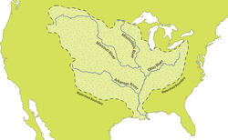
This region is a powerhouse of hydrology, acting as the nation's largest drainage basin. It drains approximately 41% of the contiguous United States, funneling water into the Gulf of Mexico at an average rate of 470,000 cubic feet per second.
Key Facts
- Size: Approximately 3 million acres of land, including 2.7 million acres of coastal wetlands.
- Global Rank: The 7th largest river delta in the world.
- Ecological Importance: Contains 37% of the estuarine marsh (marshland connected to the sea) in the contiguous U.S.
- Drainage: Processes water from 41% of the contiguous United States.
- Economic Role: A primary hub for U.S. oil and natural gas production and refining.
Geologic History and Formation
The foundation of the delta began roughly 100 million years ago during the late Cretaceous Period with the formation of the Mississippi embayment, a structural depression that began focusing sediment into the Gulf of Mexico. Over millions of years, this process evolved:
- Paleogene Period: Regional rivers increased the dispersion of sediment across southern Louisiana.
- Miocene Epoch: The embayment became the primary focus of deposition, building the modern delta's foundation.
- Holocene Epoch: Around 7,500 to 8,000 years ago, a deceleration in sea level rise allowed the modern delta plain to evolve.
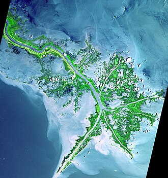
The modern delta is a river-dominated system, meaning the river's sediment output exerts more influence than ocean currents or tides. This is most evident in the "birdfoot" shape of the current delta. Historically, the river underwent avulsion—the process of abandoning its current channel for a shorter, steeper route to the sea—approximately every 1,000 to 1,500 years. These shifts created various delta lobes, contributing to over four million acres of coastal wetlands.
The Evolution of Delta Lobes
The coastline has been shaped by a sequence of lobes that grew and decayed over millennia. These include the Salé-Cypremort, Cocodrie, Teche, St. Bernard, Lafourche, Plaquemine, and Balize lobes.
![Mississippi Delta lobes Salé-Cypremort 4,600 years BP[11] Cocodrie 4,600–3,500 years BP[11] Teche 3,500–2,800 years BP[11] St. Bernard 2,800–1,000 years BP[11] Lafourche 1,000–300 years BP[11] Plaquemine 750–500 years BP[11] Balize 550 years[11]](/images/0b/df/0bdf10499989e1e67d6ec533b7c7569eaf6887ab60103ad8f41605ff601142f6.jpg)
Economic and Ecological Significance
The Mississippi River Delta is vital to the United States' energy security and economy. The oil and gas industry employs roughly one-sixth of the Louisiana workforce. Louisiana ranks second only to Texas in total refinery capacity, and Port Fourchon is a critical infrastructure point, servicing 90% of the offshore oil rigs in the Gulf of Mexico and providing 16-18% of the nation's oil supply.
Natural gas is equally significant. Since the first field was discovered in 1823, the region has grown to produce over one-tenth of U.S. natural gas supplies, supported by nearly 50,000 miles of pipelines.
Diverse Landscapes and Wildlife
The delta's ecology is characterized by a variety of landscapes, including beaches, coastal flatwoods, and bottomland hardwood and maritime forests. This biodiversity supports several endangered and threatened species, such as:
- Piping plover (Charadrius melodus)
- Kemp's Ridley Turtle (Lepidochelys kempii)
- Louisiana black bear
Environmental Threats and Restoration
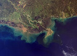
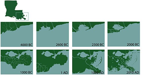
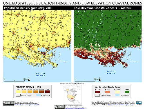
Despite taking thousands of years to build, the delta is disappearing rapidly. Several factors contribute to this land loss, including subsidence (the gradual sinking of land), sea level rise, and the impact of hurricanes. Human interventions, such as the construction of levees since the 1930s, have prevented the river from naturally depositing sediment across the wetlands, while navigation canals and upriver dams further disrupt the sediment flow.
The vulnerability of the region is stark; without sediment input, estimates suggest 4,000 to 5,000 square miles of the delta could be submerged by the year 2100.
Restoration Efforts
To combat this, the 2012 Louisiana Coastal Master Plan and the RESTORE Act have implemented various strategies. One primary focus is redirecting sediment. The Atchafalaya River Basin, which contains the state's largest tract of naturally built new marsh, is a key area for this. For example, the Wax Lake Outlet has grown by 11.3 square miles since 1973 due to sediment deposition.
| Feature | Detail |
|---|---|
| Total Area | 3 million acres |
| Wetland Area | 2.7 million acres |
| Drainage Basin | 41% of contiguous U.S. |
| Primary Industry | Oil and Natural Gas |
| Key Threat | Subsidence and Sea Level Rise |
| Major Port | Port Fourchon |
Frequently Asked Questions
What is a river-dominated delta?
A river-dominated delta occurs when the sediment deposited by a river outweighs the erosive power of the ocean's waves and tides, allowing the land to build outward into the sea, often creating a "birdfoot" pattern.
Why is the Mississippi River Delta losing land?
Land loss is caused by a combination of natural subsidence, rising sea levels, and human-made levees that prevent the river from distributing the sediment necessary to replenish the wetlands.
How important is the delta to the U.S. energy supply?
It is critical; Port Fourchon alone services 90% of Gulf offshore rigs, and the region provides 16-18% of the country's oil and over 10% of its natural gas.
What is river avulsion?
Avulsion is the process where a river abruptly changes its course to find a shorter, more efficient path to the sea. In the Mississippi's history, this occurred roughly every 1,000 to 1,500 years before modern levee systems were built.
What is being done to save the delta?
Efforts include the Louisiana Coastal Master Plan and the RESTORE Act, which focus on redirecting sediment from the river into starving wetlands to rebuild land and increase coastal resiliency.