Discovering Miryang: A Journey Through History, Culture, and Nature
Nestled in the South Gyeongsang Province of South Korea, Miryang is a city where ancient traditions meet modern connectivity. Known for its breathtaking natural landscapes and its deep roots in Korean folk culture, Miryang offers a unique glimpse into the heart of the Yeongnam region. Whether you are drawn to its historical landmarks, its role in the Korean independence movement, or its scenic river valleys, Miryang is a destination of profound significance.

Key Facts
- Location: South Gyeongsang Province, South Korea.
- Population: Approximately 100,802 (as of September 2024).
- Major Transport: A key stop on the Gyeongbu Line, featuring KTX express train service.
- Cultural Icon: Home to the famous Miryang Arirang folk song.
- Geography: Situated within the Nakdong River basin, featuring the Yeongnam Alps.
A Rich Historical Tapestry
The history of Miryang stretches back to the Samhan period, when the area was known as Mirimidongguk. Over the centuries, it transitioned through various states, including the Geumgwan Gaya confederacy, before being annexed by the Silla Kingdom in 505 AD. During the Joseon Dynasty, the city served as a vital station on the Great Yeongnam Road, cementing its importance as a hub for travel and commerce.
Miryang also holds a place of honor in Korea's struggle for independence. During the March First Movement of 1919, approximately 13,500 residents participated in peaceful demonstrations. This period of resistance also saw the heroic actions of independence activist Choe Su-bong, who targeted local occupation infrastructure in 1920.

Administrative Evolution
The city's administrative structure has shifted many times. Following the reorganization of local governments, the modern Miryang-si (Miryang City) was established in 1995 after reuniting the city center with its surrounding rural areas. Today, the city is managed by a directly elected mayor and city council, providing local autonomy to its residents.
Geography and Climate
Miryang's landscape is defined by its relationship with water. The city lies entirely within the Nakdong River basin, with the Nakdong River forming its southern boundary. The terrain is diverse, sloping from the high, rugged peaks of the Yeongnam Alps in the northeast down to the fertile valleys in the southwest.

The Miryang River flows through the city center before joining the Nakdong at Samnangjin. This river valley creates a fertile plain that serves as a regional "breadbasket," primarily dedicated to rice farming. In contrast, the higher, hillier regions are better suited for livestock farming.
Weather Patterns
Miryang enjoys a relatively mild, temperate climate. While the northern mountains offer some protection from cold winds, the valleys can be susceptible to flooding during the monsoon season or typhoons. The city experiences four distinct seasons, with an average annual temperature of 14.4 °C (57.9 °F).
Culture, Education, and Economy
Culture is the heartbeat of Miryang. The city is world-renowned for the Miryang Arirang, a folk song believed to be one of the most authentic forms of the traditional Korean Arirang. Every May, the city hosts the Miryang Arirang Festival to celebrate this heritage. The city is also famous as the filming location for the 2007 film Secret Sunshine.

Educational Excellence
Education has been a priority in Miryang since the Goryeo period, when government-run village schools (hyanggyo) were established. Today, the city's higher education is anchored by the Pusan National University Miryang campus, which specializes in science and technology, specifically in nano-science and biological sciences.

Economic Drivers
The economy is a blend of traditional agriculture and modern tourism. While rice cultivation remains a staple in the river valleys, the city's reputation as a scenic destination brings significant visitors. Furthermore, its position as a transportation hub—being the only city between Busan and Daegu served by KTX express trains—supports local commerce and logistics.
Tourism and Landmarks
For travelers, Miryang offers a wealth of natural and historical sites. The Yeongnamnu Pavilion provides a stunning view of the Miryang River and has inspired countless poets throughout history. Nature lovers can explore the "Ice Valley" of Eoreumgol or hike the peaks of the Yeongnam Alps.
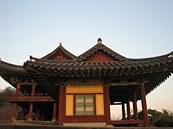
History enthusiasts can visit Pyochungsa Temple, which houses the unique Pyochung Seowon (a Confucian academy), or explore the picturesque Yangyangji reservoir, a site that has been used for irrigation since the Silla period.
Summary of Administrative Divisions
| District Type | Number of Divisions | Key Characteristics |
|---|---|---|
| Eup (Large Towns) | 2 | Major hubs like Samnangjin-eup and Hanam-eup. |
| Myeon (Rural Townships) | 9 | Primarily agricultural areas. |
| Dong (City Precincts) | 5 | Urban neighborhoods within the city center. |
Frequently Asked Questions
How do I travel to Miryang from major cities?
Miryang is highly accessible via the Gyeongbu Line. It is uniquely positioned as the only city between Busan and Daegu that is served by the KTX express train, making it a convenient destination for high-speed rail travelers.
What is the most famous cultural aspect of Miryang?
The most famous cultural element is the Miryang Arirang, a traditional Korean folk song. The city celebrates this through an annual festival held every May.
What kind of landscape can I expect in Miryang?
You will find a mix of rugged mountains (part of the Yeongnam Alps) and fertile river valleys. The area is characterized by steep valleys, reservoirs, and wide plains used for rice farming.
Is Miryang a good place for students?
Yes, Miryang has a long history of education. It is home to the Pusan National University Miryang campus, which is a specialized center for science and technology studies.
What are the best natural sites to visit?
Top recommendations include the Yeongnamnu Pavilion for river views, Eoreumgol (the Ice Valley) for unique natural formations, and the Gajisan Provincial Park within the Yeongnam Alps.