Mid-City New Orleans: A Historic and Diverse Urban Hub
Located in the heart of the Crescent City, Mid-City is a vibrant neighborhood known for its eclectic charm, architectural heritage, and deep-rooted community spirit. While it may lack the high-density tourist crowds of the French Quarter, its authentic local flavor has earned it global recognition, with Time Out citing it as one of the "coolest" neighborhoods in the world in 2023.
Historically, Mid-City developed later than its neighbors. Situated on the backslope of the Mississippi River's natural levee—the gradually declining section of the flood plain—it was once considered the "back of town." Until the late nineteenth and early twentieth centuries, the area was largely backswamp, bounded by the higher elevations of the Esplanade and Metairie Ridges. Today, it stands as a testament to urban growth and resilience.
Key Facts
- Status: Listed on the U.S. National Register of Historic Places.
- Geography: Total land area of 1.66 square miles with an elevation of 0 feet.
- Diversity: Recognized as one of the most racially diverse neighborhoods in New Orleans.
- Architecture: Features a mix of Bungalow/Craftsman, Colonial Revival, and Italianate styles.
- Connectivity: Bisected by Canal Street and served by the iconic Canal Streetcar.
Geography and Boundaries
Mid-City is positioned at coordinates 29°58′19″N 90°05′49″W. The New Orleans City Planning Commission defines its official boundaries as City Park Avenue, Toulouse Street, North Carrollton Avenue, Orleans Avenue, Bayou St. John, and St. Louis Street to the north; North Broad Street to the east; and the Pontchartrain Expressway to the west.
In common local usage, the term "Mid-City" often extends to a larger area bounded by the beltway formed by Interstates 10 and 610. The neighborhood is surrounded by several other distinct areas, including Navarre, City Park, and Bayou St. John to the north, Tulane/Gravier to the east, Gert Town to the south, and Dixon and Lakewood to the west.
Landmarks and Architecture
The neighborhood is defined by its strategic thoroughfares. Canal Street, a primary city artery, runs through the center, while the streetcar route continues along Carrollton Avenue. Tulane Avenue, the terminus of U.S. Route 61, also traverses the area; it served as the main route from Baton Rouge before the creation of the interstate system.
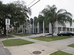
Architecturally, Mid-City is a blend of residential and industrial history. While the landscape is dotted with traditional shotgun houses (narrow houses with rooms arranged one behind the other) and larger estates, several prominent structures stand out:
- The Orleans Parish Criminal Court
- Faubourg Brewing Company
- Jesuit High School and Warren Easton High School
- The former Falstaff Brewery, now converted into apartments
- Xavier University of Louisiana, located near the Norman C. Francis Parkway
Culture and Community Life
Mid-City is primarily a middle-class residential area. Because it has fewer tourist attractions than other districts, its bars and restaurants cater largely to locals, fostering a quirky and authentic atmosphere. One of the neighborhood's most unique former traditions was the New Year's Eve bonfire on Orleans Avenue, where residents would burn their Christmas trees and set off fireworks.

Impact of Hurricane Katrina
The neighborhood suffered extensive flooding following Hurricane Katrina. In the years that followed, a significant rebuilding effort took place, with reconstruction and repopulation focusing heavily along the major thoroughfares. By March 2007, estimates indicated that approximately 55% of residents had returned to the area.
Education and Public Services
Public education in the area is managed by the New Orleans Public Schools and the Recovery School District. Notable institutions include Warren Easton Senior High School. The community is also served by the New Orleans Public Library via the Mid-City Branch.
| Category | Details |
|---|---|
| Total Area | 1.66 sq mi (4.3 km) |
| Elevation | 0 ft (0 m) |
| Population (2010) | 14,633 |
| NRHP Status | Added December 10, 1993 |
| Primary Styles | Bungalow/Craftsman, Colonial Revival, Italianate |
Frequently Asked Questions
What makes Mid-City a historic district?
Mid-City is listed on the National Register of Historic Places due to its significant collection of architecture, including Italianate, Colonial Revival, and Bungalow/Craftsman styles, as well as its historical development as a residential hub.
How did the geography of Mid-City affect its early settlement?
Because it was located on the backslope of the Mississippi River natural levee and was essentially a "backswamp," it was settled much later than adjacent neighborhoods that sat on higher ground.
What are the primary transportation routes in Mid-City?
The neighborhood is bisected by Canal Street and Carrollton Avenue, both of which are served by the streetcar. Tulane Avenue also serves as a major route through the district.
How has the population changed over time?
According to census data, the population was 19,909 in 2000 and decreased to 14,633 by 2010, reflecting the impact of Hurricane Katrina and the subsequent recovery process.
Is Mid-City a tourist-heavy area?
No, Mid-City is generally a local, middle-class neighborhood with fewer tourist destinations than other parts of New Orleans, which contributes to its authentic, "quirky" local flavor.