Megalopolis: The Rise of Global Supercities and Megaregions
In the modern era of rapid urbanization, the boundaries between cities are beginning to blur. What were once distinct metropolitan areas are merging into massive, interconnected urban networks known as megalopolises, supercities, or megaregions. These entities represent a new scale of human settlement, where multiple cities function as a single, continuous urban area linked by shared economic, transport, and ecological systems.
While the individual cities within a megalopolis maintain their own unique identities, their integration is so deep that coordinating policy across the entire region becomes essential for sustainable growth and efficiency.
Key Facts
- Definition: A cluster of adjacent metropolitan areas perceived as a continuous urban area.
- Origin: The term comes from the Greek megalo-polis, meaning "big city."
- Pioneer: Jean Gottmann popularized the modern concept in the 1950s and 60s, focusing on the U.S. Northeast.
- Scale: Population thresholds vary, with Gottmann suggesting 25 million and Doxiadis suggesting 10 million for smaller clusters.
- Drivers: Development is heavily aided by interlinked ground transportation corridors like highways and rail.
Etymology and Historical Evolution
The word megalopolis dates back to the 4th century BC, originally serving as the name for a settlement in Arcadia, Greece. By 1832, the term had evolved into a geographic description for very large, heavily populated urban complexes.
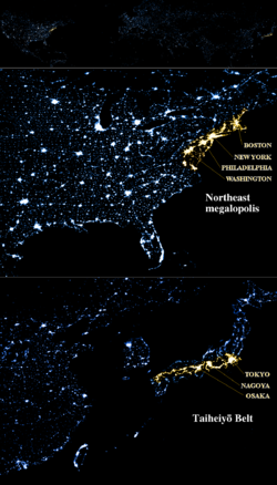
The modern academic application of the term was spearheaded by Jean Gottmann, a professor at the University of Paris and member of the Institute for Advanced Study at Princeton. In his seminal work, "A Study of Megalopolis," Gottmann described the urbanized northeastern seaboard of the United States—stretching from Boston, Massachusetts, to Washington, D.C.—as a "world of ideas," establishing the blueprint for how we analyze large-scale urban patterns today.
Modern Definitions and Global Variations
Today, a megalopolis is viewed as a clustered network of big cities. The blurring of boundaries occurs through commonalities in transport, resources, and economy. In the United States and Canada, the Regional Plan Association's "America 2050" program identifies 11 such megaregions.
Different nations apply the concept through their own linguistic and legal frameworks:
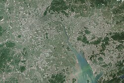
- China: The official term is chéngshì qún (city cluster), defined as an area where cities are densely distributed. This is distinct from a "metropolitan area," which is smaller in scale.
- Brazil: The term megarregião has a specific legal meaning, differing from the general English usage and relating to the country's mesoregions and microregions.
The act of traveling through these vast urban corridors via commuter passageways is informally referred to as megaloping.
Measuring Urban Scale: The Urban Metric System (UMS)
Because national census definitions vary, the Urban Metric System (UMS) was conceived to provide a standardized way of computing urban limits. UMS uses vector field calculations based on attractive and repulsive forces exerted by inhabitants and jobs.
The system categorizes urban areas based on the distance at which these forces balance, using a parameter known as β.
| Urban Area Type | Balance Distance | Value of β |
|---|---|---|
| Central city | 10 km | 6 |
| Agglomeration | 20 km | 11 |
| Metropolis | 40 km | 21 |
| Patropolis | 80 km | 41 |
| Megalopolis | 160 km | 81 |
| Urban system | 320 km | 161 |
| Urban macrosystem | 640 km | 321 |
Global Examples of Megalopolises
Megalopolises exist on every inhabited continent, reflecting the concentration of economic power and population. Notable examples include:
- North America: The Northeast corridor, Florida, Cascadia, and the Great Lakes region.
- Asia: The Taiheiyō Belt (Japan), the Yangtze and Pearl River Delta (China), and Mega Manila (Philippines).
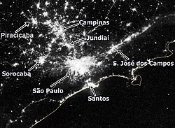
- South America: The Rio-São Paulo axis in Brazil and the Santiago-Valparaiso corridor in Chile.
- Africa: The Abidjan-Lagos corridor and the Cairo/Nile Delta.
- Europe: The Blue Banana (often referred to as the Orange or Green banana in various contexts) and the Atlantic Axis.
Megalopolises in Popular Culture
The concept of the supercity has long fascinated science fiction writers and filmmakers, often serving as a metaphor for extreme urbanization or dystopian control.
- Judge Dredd: Features "Mega-City One," a massive city-state covering much of the Eastern United States and parts of Canada.
- The Sprawl Trilogy: William Gibson envisions "the Sprawl" (BAMA), a continuous urban mass from Boston to Atlanta enclosed in geodesic domes.
- Megalopolis (Film): Francis Ford Coppola's 2024 film depicts the construction of a futuristic city using a material called "Megalon."
- Dune: The planet Arrakis features the megalopolis "Carthag" under Harkonnen rule.
Frequently Asked Questions
What is the difference between a metropolis and a megalopolis?
A metropolis is typically a single large city and its surrounding suburbs. A megalopolis is a larger-scale network consisting of two or more adjacent metropolitan areas that have merged into a continuous urban region.
Who first defined the modern megalopolis?
Jean Gottmann, a professor of political science, is credited with the modern definition. He applied the term to the northeastern seaboard of the U.S. in the late 1950s and early 1960s.
How does China define this concept?
China uses the term "city cluster" (chéngshì qún) to describe areas where cities are densely distributed. This is officially distinguished from a "metropolitan area," which is smaller in scale.
What is "megaloping"?
Megaloping is an informal term coined by Davide Gadren and Stefan Berteau to describe the act of traveling through a megalopolis using its interlinked ground transportation corridors, such as highways and rail.
What is the Urban Metric System (UMS)?
The UMS is a proposed standardized method for defining urban area limits using vector field calculations of attractive and repulsive forces, aiming to replace disparate national census definitions.