Lower Ninth Ward: History, Resilience, and Recovery in New Orleans
The Lower Ninth Ward is a historic neighborhood in New Orleans, Louisiana, defined by its unique geography and an enduring spirit of resilience. Located downriver toward the mouth of the Mississippi River, the area is a distinct part of the city's 9th Ward, which was established as a voting district in 1852. Today, it is known not only for its rich cultural heritage and architectural landmarks but also for its struggle and recovery following some of the most devastating natural disasters in American history.
Key Facts
- Location: New Orleans, Louisiana, situated below the rest of the city relative to the Mississippi River.
- Composition: Includes the Holy Cross area and several voting districts.
- Defining Feature: Bisected from the Upper 9th Ward by the Industrial Canal.
- Major Landmarks: Jackson Barracks and the Doullut "steamboat houses."
- Catastrophic Events: Severely impacted by Hurricane Betsy (1965) and Hurricane Katrina (2005).
Geography and Layout
The neighborhood spans approximately 1.25 miles from east to west and 2 miles from north to south, excluding the swamp and industrial zones north of the Florida Canal. The developed area is traversed by three primary avenues, each featuring bridges over the Industrial Canal: St. Claude Avenue (closest to the river), Claiborne Avenue (central), and Florida Avenue (northern edge). Most local businesses are concentrated along St. Claude and Claiborne.
The area is bordered by the Venetian Isles to the north, the Holy Cross neighborhood to the south, and Bywater to the west. To the east lies the community of Arabi in St. Bernard Parish.
Historical Foundations
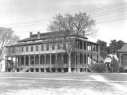
The region's formal development began in 1834 with the establishment of the Jackson Barracks by the United States Army. Throughout the 19th century, the land remained largely rural, consisting of small farms near St. Claude Avenue and undeveloped cypress swamps further inland. Infrastructure improved in 1899 with the introduction of drainage and sewage systems, followed by the completion of the first Port of New Orleans bridge into the ward in 1919.
The distinction between the "Upper" and "Lower" Ninth Ward emerged in the 1920s. The dredging of the Industrial Canal physically split the 9th Ward, creating a geographic divide that would later play a critical role in the area's vulnerability to flooding.
A Legacy of Storms and Devastation
Hurricane Betsy (1965)
In 1965, Hurricane Betsy caused a levee on the Industrial Canal to collapse, leading to widespread flooding. The disaster prompted a visit from President Lyndon B. Johnson, who ordered federal aid for the victims.
Hurricane Katrina (2005)
On August 29, 2005, Hurricane Katrina caused catastrophic failure of the levee walls protecting the ward. The Lower Ninth Ward suffered some of the worst damage in New Orleans, largely due to a storm surge amplified by the Mississippi River Gulf Outlet—a deep-draft shipping channel that had destroyed protective coastal wetlands.
Floodwaters entered from Saint Bernard Parish to the east and through two major breaches in the Industrial Canal to the west. The force of the water was so intense that homes were knocked off their foundations. A massive barge, the ING 4727, was swept into the neighborhood, leveling houses in its path. Even the highest points of the neighborhood, including the Mississippi River levee, were inundated.
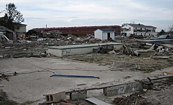
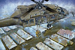
The human and demographic toll was severe. By December 2005, 72 bodies had been recovered. The population plummeted from 14,008 residents in 2000 to just 2,842 by 2010. A month after Katrina, the area was flooded once more by Hurricane Rita.
The Long Road to Recovery
Recovery began with grassroots efforts. In December 2005, the Common Ground Collective began gutting homes and providing essential supplies. Because of the extreme damage, the Lower Ninth Ward was the last part of New Orleans to have its curfew lifted and the last to receive restored power and water.
Various initiatives have attempted to revitalize the community:
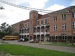
- Education: Volunteers and residents helped reopen the Martin Luther King Elementary School, which now operates as a Recovery School District charter school.
- Sustainable Housing: In 2007, actor Brad Pitt's Make It Right Foundation committed to building 150 energy-efficient, sustainable homes designed by world-renowned architects like Frank Gehry.
- Traditional Rebuilding: The non-profit Build Now focused on constructing stilt houses that mirror traditional New Orleans architecture while remaining safe from future floods.
- Environmental Maintenance: The "Nuisance Lot Maintenance Program," launched in 2011, aimed to clear overgrown vacant lots to improve neighborhood aesthetics and safety.
By October 2017, the organization lowernine.org reported having fully rebuilt 88 homes and renovated over 250 properties.
Cultural Landmarks and Notable Figures
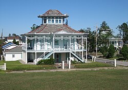
Despite the hardships, the Lower Ninth Ward remains a place of significant cultural and historical interest. The Jackson Barracks continues to serve as the headquarters for the Louisiana National Guard. Another architectural gem is the Doullut steamboat houses, built in 1905 and 1913. These landmarks were influenced by riverboat design and the 1904 World's Fair in St. Louis. Notably, Mary Doullut is believed to be the first woman to hold a Mississippi riverboat pilot's license.
The neighborhood has also been the birthplace or home of numerous influential figures, including musician Fats Domino, NFL star Marshall Faulk, and rapper Kevin Gates.
Neighborhood Summary
| Category | Details |
|---|---|
| Total Area | 2.25 sq mi (5.8 km) |
| Population (2010) | 5,560 |
| Established as District | 1852 |
| Key Infrastructure | Industrial Canal, Mississippi River |
| Primary Avenues | St. Claude, Claiborne, Florida |
Frequently Asked Questions
Why is it called the "Lower" Ninth Ward?
The term "Lower" refers to its geographic position downriver, closer to the mouth of the Mississippi River, relative to the rest of the city.
What caused the extreme flooding during Hurricane Katrina?
The flooding was caused by multiple levee breaches in the Industrial Canal and a massive storm surge. This surge was intensified by the Mississippi River Gulf Outlet, which had destroyed the coastal wetlands that normally act as a natural buffer.
What are the Doullut steamboat houses?
They are historic landmarks built in the early 20th century by riverboat pilot Captain Milton P. Doullut and his son. Their design was inspired by period steamboats and a Japanese exhibit from the 1904 World's Fair.
How has the population changed since 2000?
The population saw a drastic decline following Hurricane Katrina, dropping from over 14,000 residents in 2000 to approximately 2,842 in 2010, though recovery efforts have since brought some households back.
What is the role of the Jackson Barracks today?
The Jackson Barracks currently serves as the headquarters for the Louisiana National Guard and houses a military museum.