Lakeview New Orleans
Lakeview is a distinct neighborhood in New Orleans, Louisiana, known for its proximity to the water and its enduring spirit. Located within District 5, this community is defined by its residential charm and its relationship with the surrounding waterways. While often used to describe a broader area including West End, Lakewood, Navarre, Lakeshore, and Lake Vista, the official boundaries set by the City Planning Commission focus on a specific core area.
Key Facts
- Total Area: 1.61 square miles of land.
- Elevation: 0 feet (0.0 m).
- Population: 8,388 residents (as of 2019).
- Education: Home to Hynes Elementary School and the Robert E. Smith Branch Library.
- Geography: Bordered by Lake Pontchartrain to the north and the 17th Street Canal to the west.
Geography and Layout
Situated at coordinates 30°00′24″N 90°06′28″W, Lakeview is a low-lying area with an elevation of 0 feet. The neighborhood is characterized by its accessibility to Lake Pontchartrain, which has fostered a vibrant sailing and boating culture, supported by the Southern Yacht Club and the New Orleans Yacht Club.
The area is navigated via major north-south arteries including Pontchartrain Boulevard, West End Boulevard, and Canal Boulevard. East-west travel is primarily handled by Harrison Avenue and Robert E Lee Boulevard. Residents also enjoy the presence of two significant green spaces: City Park and New Basin Canal Park.
| Attribute | Detail |
|---|---|
| Planning District | District 5, Lakeview District |
| Land Area | 1.61 sq mi (4.2 km) |
| Population Density | 5,210 per sq mi |
| Time Zone | CST (UTC-6) / CDT (UTC-5) |
| Area Code | 504 |
Community History and Demographics
During the 19th and early 20th centuries, Lakeview was largely undeveloped swamp, though the New Basin Canal was cut through the region in the early 1800s. While the Navarre section saw slow growth early in the 20th century, the majority of the neighborhood developed after World War II, primarily featuring bungalow-style homes.
Over the decades, the neighborhood's socioeconomic profile shifted. Originally a middle-class area, it became more upscale toward the end of the 20th century, with larger modern homes replacing more modest structures. By the 1990s, it remained one of the few almost entirely white neighborhoods in New Orleans. According to 2019 American Community Survey data, the neighborhood consists of 8,388 people and 3,160 households, with 31% of residents holding a graduate or professional degree.
The Impact of Hurricane Katrina
On August 29, 2005, Hurricane Katrina caused a catastrophic failure of the levee floodwall along the 17th Street Canal. This breach allowed floodwaters from Lake Pontchartrain to inundate the neighborhood in minutes, with some areas experiencing up to fourteen feet of water. The force of the surge was so powerful that it uprooted trees and displaced houses from their foundations.
The human toll was significant, particularly among the elderly. While many evacuated, bodies were discovered in attics as late as March 2006. The recovery process was slow; by early 2006, only a few homes were restored, often with residents living on the second floor while the first floor was gutted.
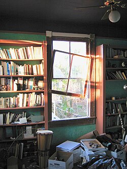
By the spring of 2007, the neighborhood showed signs of recovery. FEMA trailers provided temporary housing, and a few retail stores and restaurants reopened. However, the recovery was complicated by the Army Corps of Engineers' repair work on the 17th Street Canal, which involved the controversial expropriation of some residential properties.
Education and Public Services
Primary and Secondary Education
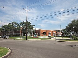
Public education in Lakeview is managed by New Orleans Public Schools (NOPS) and the Recovery School District. A cornerstone of the community is Hynes Elementary School, which opened in 1952. After suffering flood damage during Hurricane Katrina and closing for the remainder of the 2005–2006 school year, it transitioned to a Type 3 charter in March 2006.
Public Libraries
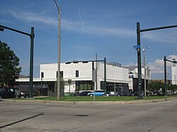
The Robert E. Smith Branch Library serves as a vital community hub. After the original library was destroyed by Katrina, a modular building funded by the Gates Foundation served as a temporary site. In March 2012, a new $4.6-million, 12,700-square-foot facility opened. This modern library was built using a "design-build" process—a streamlined method allowed under Louisiana law for Katrina-affected parishes.
Designed by Lee Ledbetter & Associates and Gould Evans & Associates, the facility emphasizes energy efficiency and public transportation access. It houses approximately 40,000 volumes and 17 computers, with additional funding provided by the Friends of the Library and the Louisiana Recovery Authority.
Religious Heritage
The Roman Catholic Archdiocese of New Orleans has a long-standing presence in the area. The first church in the neighborhood, Ave Maria Church, was dedicated on October 21, 1912, though the building was unfortunately demolished by a weather event on September 29, 1915.
Frequently Asked Questions
What are the official boundaries of Lakeview?
The City Planning Commission defines Lakeview as the area bounded by Robert E Lee Boulevard to the north, Orleans Avenue to the east, Florida Boulevard, Canal Boulevard, and I-610 to the south, and Pontchartrain Boulevard to the west.
How did Hurricane Katrina affect the neighborhood?
A catastrophic breach of the 17th Street Canal floodwall led to severe flooding, with some areas receiving up to 14 feet of water, destroying homes and causing significant loss of life, particularly among the elderly.
What is the Robert E. Smith Branch Library?
It is a 12,700-square-foot public library facility that opened in March 2012. It was rebuilt using recovery funds and bonds after the previous library was destroyed by Hurricane Katrina.
What is the typical housing style in Lakeview?
Large-scale residential development occurred after World War II, with bungalows being the predominant housing style, although many have since been replaced by larger, more upscale homes.
Which parks are located in or near Lakeview?
The neighborhood is dominated by two large parks: New Basin Canal Park and City Park.