New Orleans East: A Profile of the City's Eastern Frontier
New Orleans East (also known as Eastern New Orleans or N.O. East) is a vast region comprising the eastern section of New Orleans, Louisiana. While it represents 65% of the city's total land area, it remains geographically distinct, separated from the urban core by the Inner Harbor Navigational Canal, commonly referred to as the Industrial Canal. Surrounded by water—including Lake Pontchartrain, Lake Borgne, the Gulf Intracoastal Waterway, and the Rigolets—this area of the 9th Ward transitioned from undeveloped swampland to a suburban hub in the late 20th century.
Today, the region is a diverse residential and economic zone. As of the 2020 census, it is home to 75,223 people, accounting for 20% of the city's total population. The landscape varies from working-class neighborhoods and low-income multifamily complexes to affluent gated communities centered around the lakes.
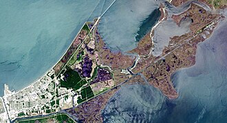
Key Facts
- Land Area: Comprises 65% of New Orleans' total land.
- Population: 75,223 residents (2020 Census).
- Geography: Bounded by the Industrial Canal, Lake Pontchartrain, Lake Borgne, and the Gulf Intracoastal Waterway.
- Major Employers: NASA Michoud Assembly Facility, New Orleans Lakefront Airport, and the National Finance Center.
- Nature: Home to the Bayou Sauvage Urban National Wildlife Refuge, the largest urban wildlife refuge in the U.S.
Historical Evolution
Early Development and Infrastructure
Residential growth began in the early 20th century as an extension of Gentilly. A pivotal moment occurred between 1918 and 1923 with the completion of the Industrial Canal, which established the primary physical barrier between the East and the rest of the city. By 1944, the southern boundary was finalized through the re-routing of the Intracoastal Waterway, cutting through raw swampland.
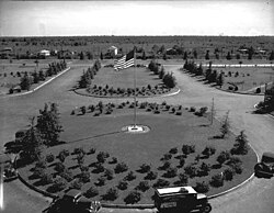
The Suburban Boom (1960s–1970s)
Under Mayor Vic Schiro (1961–1970), the area experienced rapid growth. It was designed as a "suburb-within-the-city," catering to residents seeking a suburban lifestyle without leaving city limits. Unlike other areas, New Orleans East was carefully zoned; major roads were placed equidistant from drainage canals and featured landscaped medians, known locally as neutral grounds. To maintain a clean visual aesthetic, buried utilities were required for new developments, avoiding the tangled power lines common elsewhere in the city.
![Advertisement for proposed development "Flowerdale", from The New Orleans Bee in 1914; the area was not developed as planned and is now under a landfill.[1]](/images/3c/d8/3cd8cf81b7094082300587325193d6acc696bdcc45e8e20e2034a39e4f0267dc.png)
Demographic Shifts and Economic Challenges
Originally a majority-white area, the region saw a demographic sea-change in the 1980s as the African American middle class moved in. However, the 1986 Oil Bust brought economic hardship. Many garden apartments, originally built for young professionals, began housing low-income, female-headed households. This increase in poverty led to higher crime rates and a swift exodus of the white population, leaving the area overwhelmingly African American by 2005.
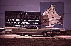
The "New Town" Vision
During the 1970s oil boom, developers envisioned a massive planned community called "New Orleans East" (also referred to as Pontchartrain or Orlandia), modeled after Reston, Virginia. While only small portions like Village de L'Est and Oak Island were completed, the grand vision failed. Much of the intended development land eventually became the Bayou Sauvage National Wildlife Refuge.
Hurricane Katrina and the Path to Recovery
On August 29, 2005, Hurricane Katrina caused severe flooding in New Orleans East due to levee failures. The recovery was slow; by November 2006, only 40,000 of the pre-storm 95,000 residents had returned. Many residents lived in FEMA trailers while repairing flood-damaged homes.
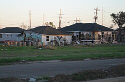
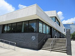
Post-Katrina recovery saw a shift in housing; homeowners lobbied against new rental developments to reduce the density of multifamily housing. Essential services were slow to return; for years, the area lacked a general hospital until the New Orleans East Hospital (NOEH) opened in 2014 in the former Methodist Hospital building. Recent public investments include a new regional public library and several new public school buildings.
Economic and Community Infrastructure
Economic Drivers
The region hosts several critical industrial and commercial entities, including the NASA Michoud Assembly Facility, the Folgers Coffee Plant, and Textron. The New Orleans Regional Business Park (Higgins Innovation District) and the New Orleans East Economic Development Fund (NOEEDF)—established in 1995 via voter-approved taxes—work to bolster local business and job creation.
Education and Culture
The educational landscape has evolved with the rise of charter schools, such as the Abramson Science and Technology Charter School. A landmark of community investment is the New Orleans Public Library's eastern branch, a $7.6 million contemporary building opened in 2012.
Notable Residents
The area has been home to many influential figures, including R&B singer Aaron Neville, Grammy winner Irma Thomas, Oscar-nominated actress Hong Chau, and activist Ruby Bridges.
Regional Summary
| Category | Details |
|---|---|
| Land Area | 65% of New Orleans total |
| Population (2020) | 75,223 |
| Key Infrastructure | I-10, Industrial Canal, New Orleans Lakefront Airport |
| Major Parks | Bayou Sauvage, Joe W. Brown Park, Lincoln Beach |
| Primary Hospital | New Orleans East Hospital (NOEH) |
Frequently Asked Questions
What is the Industrial Canal's role in New Orleans East?
The Industrial Canal serves as the primary geographical barrier that isolates New Orleans East from the rest of the city, creating a distinct physical and social boundary.
What is the Bayou Sauvage National Wildlife Refuge?
It is the largest urban wildlife refuge in the United States, occupying much of the land that was originally intended for the failed "New Town" development of the 1970s.
How did Hurricane Katrina affect the area's healthcare?
Both Methodist and Lakeland hospitals closed after the storm, leaving the region without emergency or general hospital care for several years until New Orleans East Hospital opened in 2014.
What was the "New Town" project?
It was an ambitious 1970s plan to create a massive, planned community similar to The Woodlands in Texas. Only a few neighborhoods, such as Village de L'Est, were actually built.
What is the NOEEDF?
The New Orleans East Economic Development Fund is a tax-funded initiative created in 1995 to support local businesses and infrastructure to stimulate economic growth and reduce crime in the area.