Broadmoor: A Resilient New Orleans Neighborhood
Broadmoor is a distinct neighborhood in New Orleans, Louisiana, serving as a subdistrict of the Uptown/Carrollton Area. Known for its architectural charm and a powerful spirit of community resilience, Broadmoor has evolved from a low-lying marsh into a vibrant residential hub. Its identity is deeply tied to its struggle with water—from early 20th-century drainage projects to its recovery following devastating floods.
Key Facts
- Location: District 3, Uptown/Carrollton, New Orleans, Louisiana.
- Elevation: Approximately 2 feet (0.61 m) above sea level.
- Historic Status: Home to the Broadmoor Historic District, listed on the National Register of Historic Places.
- Land Area: 0.56 square miles.
- Notable Landmarks: Rosa F. Keller Library and Andrew Wilson Elementary School.
History and Development
Originally a large marsh used as a fishing spot for residents of Uptown, Broadmoor remained largely undeveloped until the early 1900s. The area's growth was made possible by the introduction of drainage canals in 1885 and the opening of a pumping station at Broad Street and Washington in 1903. By 1915, more powerful pumps were installed, encouraging settlers to move into the area.
The 1920s marked a period of rapid expansion. During this decade, more than one-third of the neighborhood's homes were constructed, along with the Wilson School, the area's first public school. However, this growth slowed in the late 1950s and 1960s as residents migrated toward New Orleans East and suburbs in Jefferson Parish.
Broadmoor's geography has made it susceptible to severe flooding. It was hit hard by the Louisiana Flood of May 8, 1995, and suffered catastrophic damage during Hurricane Katrina in 2005. In the wake of Katrina, some preliminary reports suggested converting Broadmoor into parkland. This proposal was met with strong resistance from residents, many of whom returned to their homes as early as January 2006 to begin the arduous process of gutting and repairing their properties.
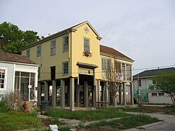
Recent years have seen a focus on restoration. In 2016, the vacant Gem Theater was added to the National Register of Historic Places and subsequently reopened as a microbrewery.
Geography and Boundaries
Broadmoor is situated at 29°56′56″N 90°06′15″W with a total land area of 0.56 square miles. It is positioned near the wealthy communities of the Garden District and Uptown, and is close to South Claiborne Avenue, a major artery connecting Downtown New Orleans to Jefferson Parish.
The New Orleans City Planning Commission defines the neighborhood's boundaries by the following streets:
- North: Eve Street
- East: Washington Avenue and Toledano Street
- South: South Claiborne Avenue
- West: Jefferson Avenue, South Rocheblave Street, Nashville Avenue, and Octavia Street
The Broadmoor Historic District
The Broadmoor Historic District is recognized for its diverse architectural styles, including Bungalow/Craftsman and Colonial Revival homes. The district was first listed on the National Register of Historic Places on June 13, 2003, with its boundaries expanded on September 13, 2007.
Community Institutions and Education
Andrew Wilson Elementary School
Built in 1922, the Andrew Wilson Elementary School is a cornerstone of the community. After suffering severe flooding and neglect leading up to and during Hurricane Katrina, the building was nearly razed to create green space. However, local activists successfully campaigned for a $30 million renovation. The school reopened on January 4, 2010, as a high-tech, eco-friendly facility.
Rosa F. Keller Library and Community Center
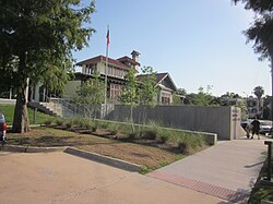
The Rosa F. Keller Library and Community Center serves as a vital public resource. Rebuilt after Hurricane Katrina and opened on March 16, 2012, the site combines a modern library with the 1918 Hardie-Fattel house. This historic addition functions as a community center featuring a teaching kitchen, coffee shop, and various meeting rooms. The project was supported by a $2 million grant from the Carnegie Corporation and designed by the firm Eskew+Dumez+Ripple.
Demographics and Notable Residents
Broadmoor has seen a shift in population over the last two decades. In 2000, the population was 7,232 with a density of 12,914 per square mile. By 2010, the population was 5,381. The 2010 census recorded a racial makeup of 61.1% African American, 28.8% White, 1.0% Asian, 0.3% Native American, and 1.6% from two or more races, with 6.7% of the population identifying as Hispanic or Latino.
The neighborhood has been home to several prominent figures, including:
- Mayors of New Orleans: Moon Landrieu, Mitch Landrieu, and Latoya Cantrell.
- Arts and Letters: Musician and producer Dave Bartholomew (who named his Broadmoor Records label after the area), writer Poppy Z. Brite, and biographer Walter Isaacson.
- Historical Figures: David Ferrie.
| Category | Details |
|---|---|
| Total Area | 0.56 sq mi |
| Elevation | 2 ft (0.61 m) |
| Population (2010) | 5,381 |
| Historic District Listing | 2003 (Expanded 2007) |
| Primary Architectural Styles | Bungalow/Craftsman, Colonial Revival |
Frequently Asked Questions
What is the Broadmoor Historic District?
It is a designated area on the U.S. National Register of Historic Places, recognized for its Colonial Revival and Bungalow/Craftsman architecture. It was first listed in 2003 and expanded in 2007.
How did Hurricane Katrina affect Broadmoor?
Broadmoor suffered severe flooding. While some officials suggested converting the area into parkland, residents fought to rebuild their homes and community institutions, such as the Andrew Wilson Elementary School.
What is the significance of the Rosa F. Keller Library?
Reopened in 2012, it is a modernized library and community center that incorporates the historic 1918 Hardie-Fattel house, offering educational spaces and a community garden.
Who are some of the notable people from Broadmoor?
The neighborhood has been home to three New Orleans mayors (Moon Landrieu, Mitch Landrieu, and Latoya Cantrell), as well as biographer Walter Isaacson and musician Dave Bartholomew.
Why was Broadmoor developed later than other parts of New Orleans?
Because it was originally a low-lying marsh, substantial development only began in the early 20th century after the installation of drainage canals and pumping stations to manage the water levels.